- My Forums
- Tiger Rant
- LSU Recruiting
- SEC Rant
- Saints Talk
- Pelicans Talk
- More Sports Board
- Coaching Changes
- Fantasy Sports
- Golf Board
- Soccer Board
- O-T Lounge
- Tech Board
- Home/Garden Board
- Outdoor Board
- Health/Fitness Board
- Movie/TV Board
- Book Board
- Music Board
- Political Talk
- Money Talk
- Fark Board
- Gaming Board
- Travel Board
- Food/Drink Board
- Ticket Exchange
- TD Help Board
Customize My Forums- View All Forums
- Show Left Links
- Topic Sort Options
- Trending Topics
- Recent Topics
- Active Topics
Started By
Message
 3
3

Posted on 10/5/17 at 3:54 pm to bubbz
000
WTNT41 KNHC 052045
TCDAT1
Tropical Storm Nate Discussion Number 6
NWS National Hurricane Center Miami FL AL162017
500 PM EDT Thu Oct 05 2017
The center of Nate is now over eastern Honduras, and the cloud
pattern has lost some organization since the last advisory due to
passage over land. In addition, recent ASCAT overpasses suggest
that there are no tropical-storm-force winds outside of the coastal
waters of Nicaragua and Honduras. However, surface observations
indicate that the central pressure remains near 1000 mb, and based
on this the initial intensity remains a possibly generous 35 kt.
An Air Force Reserve Hurricane Hunter aircraft is scheduled to
investigate Nate as it emerges from the northern coast of Honduras
around 0300 UTC.
Analyses from CIMSS at the University of Wisconsin suggest that
Nate is currently experiencing about 20 kt of southwesterly vertical
wind shear, which is more than suggested by the SHIPS model. The
large-scale models are in good agreement that this shear should
diminish during the next 12-24 h, leaving Nate in an favorable
environment for strengthening. One change in the models from the
previous advisory is that the GFS now shows more development as Nate
crosses the Gulf of Mexico. The new intensity forecast shows little
change during the first 12 h due to the shear and land interaction,
then it calls for steady intensification though landfall on the
northern Gulf Coast. After landfall, Nate should weaken as it
traverses the eastern United States. It should be noted that while
the forecast shows a peak intensity of 70 kt at 48 h, Nate is
expected to continue to strengthen between 48 h and landfall and
thus is likely to be stronger than 70 kt. It should also be noted
that SHIPS Rapid Intensification Index values remain quite high, and
any period of rapid intensification would lead to Nate being
stronger than currently forecast.
The initial motion is now 330/9. A combination of a large cyclonic
gyre over Central America, a trough of low pressure moving westward
across the Gulf of Mexico, and a building subtropical ridge over
the western Atlantic should steer Nate generally north-northwestward
with an increase in forward speed during the next 48 h or so,
followed by a turn toward the north as the storm reaches the
western end of the ridge. The guidance is in decent agreement on
the direction of motion, but there remains disagreement on the speed
despite a continued trend toward a faster motion. The new forecast
track is similar to the direction of the previous track, but again
shows a faster forward speed that now has the center near the
northeastern Yucatan Peninsula in 24-36 h and near the northern Gulf
Coast in 60-72 h. After the Gulf Coast landfall, Nate or its
remnants are expected to recurve northeastward upon encountering the
mid-latitude westerlies.
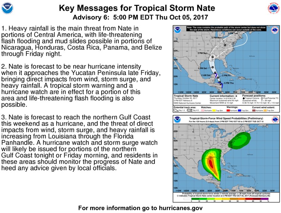
KEY MESSAGES:
1. Heavy rainfall is the main threat from Nate in portions of
Central America, with life-threatening flash flooding and mud slides
possible in portions of Nicaragua, Honduras, Costa Rica, Panama, and
Belize through Friday night.
2. Nate is forecast to be near hurricane intensity when it
approaches the Yucatan Peninsula late Friday, bringing direct
impacts from wind, storm surge, and heavy rainfall. A tropical storm
warning and a hurricane watch are in effect for a portion of this
area and life-threatening flash flooding is also possible.
3. Nate is forecast to reach the northern Gulf Coast this weekend as
a hurricane, and the threat of direct impacts from wind, storm
surge, and heavy rainfall is increasing from Louisiana through the
Florida Panhandle. A hurricane watch and storm surge watch will
likely be issued for portions of the northern Gulf Coast tonight or
Friday morning, and residents in these areas should monitor the
progress of Nate and heed any advice given by local officials.
FORECAST POSITIONS AND MAX WINDS
INIT 05/2100Z 14.9N 84.3W 35 KT 40 MPH...INLAND
12H 06/0600Z 16.5N 84.9W 35 KT 40 MPH...OVER WATER
24H 06/1800Z 19.2N 86.1W 45 KT 50 MPH
36H 07/0600Z 22.3N 87.9W 55 KT 65 MPH
48H 07/1800Z 25.6N 89.5W 70 KT 80 MPH
72H 08/1800Z 31.5N 89.5W 50 KT 60 MPH...INLAND
96H 09/1800Z 38.0N 81.5W 25 KT 30 MPH...INLAND
120H 10/1800Z 41.5N 72.0W 20 KT 25 MPH...POST-TROP/INLAND
$$
Forecaster Beven
WTNT41 KNHC 052045
TCDAT1
Tropical Storm Nate Discussion Number 6
NWS National Hurricane Center Miami FL AL162017
500 PM EDT Thu Oct 05 2017
The center of Nate is now over eastern Honduras, and the cloud
pattern has lost some organization since the last advisory due to
passage over land. In addition, recent ASCAT overpasses suggest
that there are no tropical-storm-force winds outside of the coastal
waters of Nicaragua and Honduras. However, surface observations
indicate that the central pressure remains near 1000 mb, and based
on this the initial intensity remains a possibly generous 35 kt.
An Air Force Reserve Hurricane Hunter aircraft is scheduled to
investigate Nate as it emerges from the northern coast of Honduras
around 0300 UTC.
Analyses from CIMSS at the University of Wisconsin suggest that
Nate is currently experiencing about 20 kt of southwesterly vertical
wind shear, which is more than suggested by the SHIPS model. The
large-scale models are in good agreement that this shear should
diminish during the next 12-24 h, leaving Nate in an favorable
environment for strengthening. One change in the models from the
previous advisory is that the GFS now shows more development as Nate
crosses the Gulf of Mexico. The new intensity forecast shows little
change during the first 12 h due to the shear and land interaction,
then it calls for steady intensification though landfall on the
northern Gulf Coast. After landfall, Nate should weaken as it
traverses the eastern United States. It should be noted that while
the forecast shows a peak intensity of 70 kt at 48 h, Nate is
expected to continue to strengthen between 48 h and landfall and
thus is likely to be stronger than 70 kt. It should also be noted
that SHIPS Rapid Intensification Index values remain quite high, and
any period of rapid intensification would lead to Nate being
stronger than currently forecast.
The initial motion is now 330/9. A combination of a large cyclonic
gyre over Central America, a trough of low pressure moving westward
across the Gulf of Mexico, and a building subtropical ridge over
the western Atlantic should steer Nate generally north-northwestward
with an increase in forward speed during the next 48 h or so,
followed by a turn toward the north as the storm reaches the
western end of the ridge. The guidance is in decent agreement on
the direction of motion, but there remains disagreement on the speed
despite a continued trend toward a faster motion. The new forecast
track is similar to the direction of the previous track, but again
shows a faster forward speed that now has the center near the
northeastern Yucatan Peninsula in 24-36 h and near the northern Gulf
Coast in 60-72 h. After the Gulf Coast landfall, Nate or its
remnants are expected to recurve northeastward upon encountering the
mid-latitude westerlies.
KEY MESSAGES:
1. Heavy rainfall is the main threat from Nate in portions of
Central America, with life-threatening flash flooding and mud slides
possible in portions of Nicaragua, Honduras, Costa Rica, Panama, and
Belize through Friday night.
2. Nate is forecast to be near hurricane intensity when it
approaches the Yucatan Peninsula late Friday, bringing direct
impacts from wind, storm surge, and heavy rainfall. A tropical storm
warning and a hurricane watch are in effect for a portion of this
area and life-threatening flash flooding is also possible.
3. Nate is forecast to reach the northern Gulf Coast this weekend as
a hurricane, and the threat of direct impacts from wind, storm
surge, and heavy rainfall is increasing from Louisiana through the
Florida Panhandle. A hurricane watch and storm surge watch will
likely be issued for portions of the northern Gulf Coast tonight or
Friday morning, and residents in these areas should monitor the
progress of Nate and heed any advice given by local officials.
FORECAST POSITIONS AND MAX WINDS
INIT 05/2100Z 14.9N 84.3W 35 KT 40 MPH...INLAND
12H 06/0600Z 16.5N 84.9W 35 KT 40 MPH...OVER WATER
24H 06/1800Z 19.2N 86.1W 45 KT 50 MPH
36H 07/0600Z 22.3N 87.9W 55 KT 65 MPH
48H 07/1800Z 25.6N 89.5W 70 KT 80 MPH
72H 08/1800Z 31.5N 89.5W 50 KT 60 MPH...INLAND
96H 09/1800Z 38.0N 81.5W 25 KT 30 MPH...INLAND
120H 10/1800Z 41.5N 72.0W 20 KT 25 MPH...POST-TROP/INLAND
$$
Forecaster Beven
Posted on 10/5/17 at 3:55 pm to Fun Bunch
Still could shift east of Louisiana.
Posted on 10/5/17 at 3:55 pm to bubbz

5PM advisory.
Posted on 10/5/17 at 3:56 pm to slackster
Jesus that thing is flying its arse off. Hits around 8 AM and 6 hours later it's already near central Miss.
Posted on 10/5/17 at 3:56 pm to deuce985
quote:
Analyses from CIMSS at the University of Wisconsin suggest that
Nate is currently experiencing about 20 kt of southwesterly vertical
wind shear, which is more than suggested by the SHIPS model. The
large-scale models are in good agreement that this shear should
diminish during the next 12-24 h, leaving Nate in an favorable
environment for strengthening. One change in the models from the
previous advisory is that the GFS now shows more development as Nate
crosses the Gulf of Mexico. The new intensity forecast shows little
change during the first 12 h due to the shear and land interaction,
then it calls for steady intensification though landfall on the
northern Gulf Coast. After landfall, Nate should weaken as it
traverses the eastern United States. It should be noted that while
the forecast shows a peak intensity of 70 kt at 48 h, Nate is
expected to continue to strengthen between 48 h and landfall and
thus is likely to be stronger than 70 kt. It should also be noted
that SHIPS Rapid Intensification Index values remain quite high, and
any period of rapid intensification would lead to Nate being
stronger than currently forecast.
This post was edited on 10/5/17 at 3:57 pm
Posted on 10/5/17 at 3:58 pm to slackster
anything suggesting development of more than a Cat 1 thus far?
Posted on 10/5/17 at 4:00 pm to Chad504boy
Chad aren’t you in teh insurance biz? I bet you’re salivating right now aren’t you?

Posted on 10/5/17 at 4:00 pm to Will Cover
quote:But not really saying anything.
This is from family member who is studying to become a meteorologist and plans to work for NASA or NOAA. He knows his storms.
Posted on 10/5/17 at 4:01 pm to Chad504boy
Ask tomorrow evening when it had time to sit over healthy conditions to strengthen.
Posted on 10/5/17 at 4:01 pm to deuce985
quote:
Still could shift east of Louisiana.
Yeah, the cone is still a little misleading. The problem is the forward speed of Nate means landfall is expected in the next 60-72 hours, but there is still considerable spread in the ensemble members at that point. The NHC cone is based on the typical error at a given amount of time, but it doesn't indicate the certainty, or lack thereof, of a given storm's track.
Posted on 10/5/17 at 4:05 pm to slackster
quote:
quote:
Analyses from CIMSS at the University of Wisconsin suggest that
Nate is currently experiencing about 20 kt of southwesterly vertical
wind shear, which is more than suggested by the SHIPS model. The
large-scale models are in good agreement that this shear should
diminish during the next 12-24 h, leaving Nate in an favorable
environment for strengthening. One change in the models from the
previous advisory is that the GFS now shows more development as Nate
crosses the Gulf of Mexico. The new intensity forecast shows little
change during the first 12 h due to the shear and land interaction,
then it calls for steady intensification though landfall on the
northern Gulf Coast. After landfall, Nate should weaken as it
traverses the eastern United States. It should be noted that while
the forecast shows a peak intensity of 70 kt at 48 h, Nate is
expected to continue to strengthen between 48 h and landfall and
thus is likely to be stronger than 70 kt. It should also be noted
that SHIPS Rapid Intensification Index values remain quite high, and
any period of rapid intensification would lead to Nate being
stronger than currently forecast.
This the 18z RI index for that time period:

Posted on 10/5/17 at 4:06 pm to tgrbaitn08
quote:
Chad aren’t you in teh insurance biz? I bet you’re salivating right now aren’t you?
little construction biz boom never hurt nobody!
Posted on 10/5/17 at 4:07 pm to Chad504boy
quote:
anything suggesting development of more than a Cat 1 thus far?
Certainly possible, but not something I'd bet on at this moment. Category 2 winds are 83kts, and the current forecast takes it up to 70kts, and slightly higher before landfall. It doesn't take much fluctuation to get into Cat 2 territory.
FWIW, the NHC whiffed on Maria's intensity by 40 MPH in a 24 hour span. Favorable conditions for strengthening lie ahead of Nate, so who knows.
To be clear though, Nate turning into a major storm is still unlikely at this point.
Posted on 10/5/17 at 4:09 pm to rds dc
quote:
This the 18z RI index for that time period:
What am I looking at here. Is that a 56% chance of a 65kt+ increase in winds over the next 72 hours, based on the SHIPS model?
Posted on 10/5/17 at 4:10 pm to rds dc
Northern portion of the circulation is starting to push out over the water and storms are really firing off this afternoon.


Posted on 10/5/17 at 4:11 pm to Y.A. Tittle
Kip Holden owns the greatest disaster news conference wardrobe ever. Hands f'n down.
Posted on 10/5/17 at 4:13 pm to deltaland
The pumps and generators are old and very big. Everything on them has to be custom made when they need replacement parts. The city is smart enough not to order backups, so when something goes down, it is down until another custom part gets fabricated and shipped
Posted on 10/5/17 at 4:14 pm to rds dc
It's hard to really see in that mess, but I seent it.
Not a huge fan of a bullish NHC either.
Not a huge fan of a bullish NHC either.
This post was edited on 10/5/17 at 4:15 pm

 Page 55 of 193

Popular
Back to top