- My Forums
- Tiger Rant
- LSU Recruiting
- SEC Rant
- Saints Talk
- Pelicans Talk
- More Sports Board
- Coaching Changes
- Fantasy Sports
- Golf Board
- Soccer Board
- O-T Lounge
- Tech Board
- Home/Garden Board
- Outdoor Board
- Health/Fitness Board
- Movie/TV Board
- Book Board
- Music Board
- Political Talk
- Money Talk
- Fark Board
- Gaming Board
- Travel Board
- Food/Drink Board
- Ticket Exchange
- TD Help Board
Customize My Forums- View All Forums
- Show Left Links
- Topic Sort Options
- Trending Topics
- Recent Topics
- Active Topics
Started By
Message
 1
1

Posted on 10/9/24 at 6:33 am to TheOcean
We’ve got a friend with Acadian Ambulance. They were in WNC and then drove to Fort Myers yesterday and now are in Tallahassee. I’m confused as to why they didn’t go to Miami/that side of Florida.
Seems like it would have been closer for them to get back after landfall.
Seems like it would have been closer for them to get back after landfall.
Posted on 10/9/24 at 6:39 am to mattchewbocca
quote:
I keep seeing these huge thunderstorms in the path of this storm and it almost looks like its keeping this hurricane fueled and keeping dry air out.
We’ve had such a ridiculous amount of rain on the east coast you would’ve thought the the storm had been over us for a week.
Posted on 10/9/24 at 6:45 am to pioneerbasketball
Should be pretty mundane in that area. It’s shifted far enough south that it’ll just be breezy and some rain.
Posted on 10/9/24 at 6:48 am to lsufisherman
Flood insurance is done if Tampa gets 10-15 of storm surge
South of Tampa gonna have to take this one for the sake of entire gulf coast
South of Tampa gonna have to take this one for the sake of entire gulf coast
Posted on 10/9/24 at 6:53 am to Duke
Hopefully this eyewall replacement cycle combined with the increasing shear puts a pretty significant dent into Milton on approach.
Posted on 10/9/24 at 6:55 am to Dixie2023
quote:
I’m reading possibly Ft Myers and the keys?
Looking at the satellite and trajectory, I think Tampa will have a big impact. I am guessing landfall near Sarasota or just North of there.
Although, with this current EWRC and the shear above, who REALLY knows. I think it will be clear when Milton regains the eye. Give it a couple hours.
This post was edited on 10/9/24 at 6:56 am
Posted on 10/9/24 at 6:57 am to IT_Dawg
quote:
Looking at the satellite and trajectory, I think Tampa will have a big impact. I am guessing landfall near Sarasota or just North of there.
Although, with this current EWRC and the shear above, who REALLY knows. I think it will be clear when Milton regains the eye. Give it a couple hours.
Peej already sealed Tampa's fate.

Posted on 10/9/24 at 6:58 am to nicholastiger
quote:
South of Tampa gonna have to take this one for the sake of entire gulf coast
Not really interested in being a martyr
Posted on 10/9/24 at 6:58 am to nicholastiger
quote:
Flood insurance is done if Tampa gets 10-15 of storm surge South of Tampa gonna have to take this one for the sake of entire gulf coast
They just took one 2 years ago that they’re still rebuilding from.

Posted on 10/9/24 at 7:06 am to lsufisherman
quote:
Should be pretty mundane in that area. It’s shifted far enough south that it’ll just be breezy and some rain.
Ty sir.
Posted on 10/9/24 at 7:08 am to dukke v
quote:Track has gone back north since the moment this was posted. Peej is undefeated.
Tampa looks to be dodging a major bullet here.
Posted on 10/9/24 at 7:09 am to LanierSpots
Morning Ya’ll
Got that boat secure Lanier Spot?
All the wiring looked good in past pix, make the bilge pumps run until the battery fails. Did you pull it out?
Got that boat secure Lanier Spot?
All the wiring looked good in past pix, make the bilge pumps run until the battery fails. Did you pull it out?

Posted on 10/9/24 at 7:12 am to back9Tiger
quote:
Exactly how Katrina came in. Cat 3 with a five plus storm surge. Praying for Florida in this one.
Whoa whoa whoa. Chill the hell out.
Milton has 50 mile wide hurricane wind field in diameter
Katrina had 200
This isn’t comparable AT ALL.
Posted on 10/9/24 at 7:15 am to IT_Dawg
Thanks for your explanation. Just worries me for folks who may have thought they’d be ok now at risk bc no plan But that’s how it is with hurricanes. You don’t know until it’s basically there.
Posted on 10/9/24 at 7:21 am to Beer did clam
quote:
Got that boat secure Lanier Spot?
All the wiring looked good in past pix, make the bilge pumps run until the battery fails. Did you pull it out?
Is on a trailer at the storage yard but its in the eye just a few miles inland. Under a new cover and surrounded by RV's. Hope they can block for it. I put blocks around the tires but honestly, thats about all I can do.
Thanks for asking.
I have one more board to put up on my front door this morning and thats it. I waited till the last min to do that so we could use that door the last couple of days. I think its time to put it up now. Just have that and a few chairs around my pool and Lanai.
Posted on 10/9/24 at 7:22 am to rmnldr
Milton is starting to get beat on by that shear
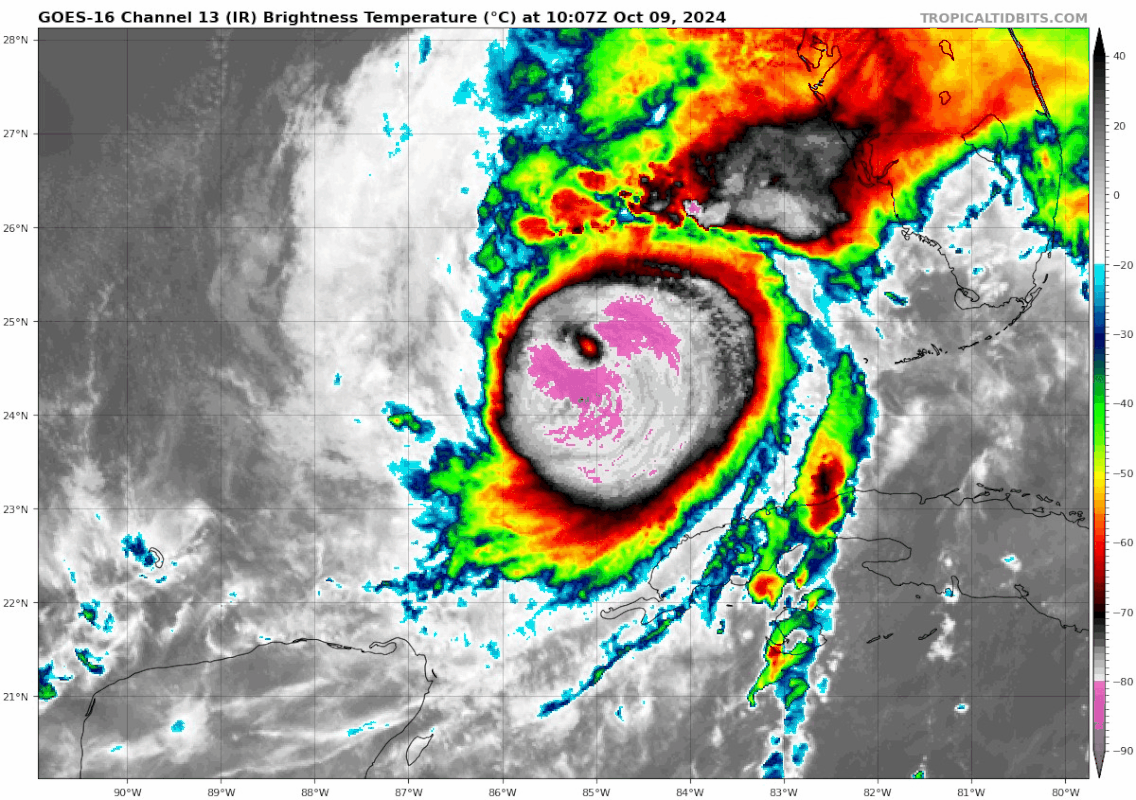
Winds are even more asymmetrical now with the shear

Winds are even more asymmetrical now with the shear
This post was edited on 10/9/24 at 7:24 am
Posted on 10/9/24 at 7:23 am to Dixie2023
Everyone in Louisiana and the Northern Gulf coast should be thanking their lucky stars for these two timely cold fronts that saved our arse with both these storms.
This post was edited on 10/9/24 at 7:27 am
Posted on 10/9/24 at 7:23 am to rmnldr
quote:
Milton has 50 mile wide hurricane wind field in diameter Katrina had 200 This isn’t comparable AT ALL.
Yeah
Katrina came in La/miss border but storm surge was felt all the way to gulf shores alabama. It is still the all time high water mark in Mobile bay- 120 miles east of landfall.
Nonetheless- Milton will be a very serious event for those along the entire western Florida coastline
Posted on 10/9/24 at 7:24 am to SlidellCajun
The wind field is going to get much larger at it will be impacted by shear/cold front. It’s been predicted to do that for days now.
This post was edited on 10/9/24 at 7:26 am

 Page 162 of 242

Popular
Back to top