- My Forums
- Tiger Rant
- LSU Recruiting
- SEC Rant
- Saints Talk
- Pelicans Talk
- More Sports Board
- Fantasy Sports
- Golf Board
- Soccer Board
- O-T Lounge
- Tech Board
- Home/Garden Board
- Outdoor Board
- Health/Fitness Board
- Movie/TV Board
- Book Board
- Music Board
- Political Talk
- Money Talk
- Fark Board
- Gaming Board
- Travel Board
- Food/Drink Board
- Ticket Exchange
- TD Help Board
Customize My Forums- View All Forums
- Show Left Links
- Topic Sort Options
- Trending Topics
- Recent Topics
- Active Topics
Started By
Message
re: Hurricane Milton - The Cleanup Begins...
Posted on 10/9/24 at 12:56 am to NorthEndZone
Posted on 10/9/24 at 12:56 am to NorthEndZone
 1
1

Posted on 10/9/24 at 1:04 am to LegendInMyMind
Beautiful but deadly image

Posted on 10/9/24 at 1:08 am to caill430
Had an owl hooting when I let the dog out.
Posted on 10/9/24 at 1:40 am to stuntman
quote:
Had an owl hooting when I let the dog out.
Hoo, hoo, hoo, hooo let the dog out?
Sorry.
Posted on 10/9/24 at 2:07 am to LegendInMyMind
Man, I needed that.

Posted on 10/9/24 at 2:19 am to NorthEndZone
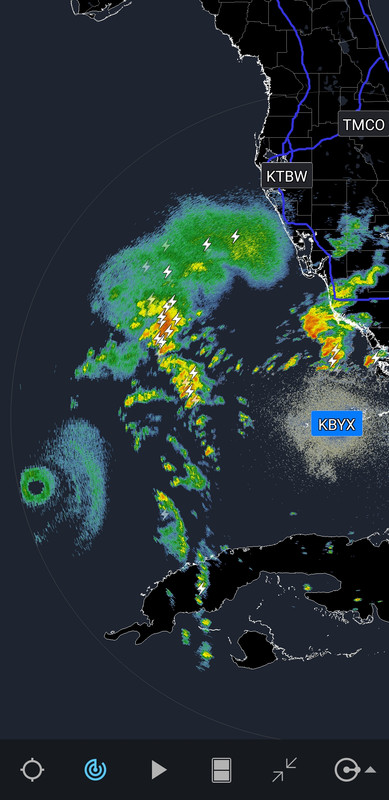
The gifs really emphasize that Milton is really steaming! The outflow north and north east looks like he’s putting a buffer out to fend off shear and dry air. Almost creating his own steering environment. And that lightning factory complex of storms he’s nudging along is a dangerous event itself. It almost as big as Milton.
It’s like occasionally these storm have or develop some kind of instincts for survival.
If I watch all the loops long enough I start getting the impression Milton wants to slide East and South a little to stay over open water, run the Florida Straights and avoid becoming absorbed and extra tropical. I’m guessing it’s traversing the loop now picking up steam.

Posted on 10/9/24 at 2:40 am to Mr. Misanthrope

Posted on 10/9/24 at 3:04 am to Mr. Misanthrope
quote:
It’s like occasionally these storm have or develop some kind of instincts for survival
WTF?
Posted on 10/9/24 at 3:26 am to Mr. Misanthrope
Hopefully this storm can get on a path to hit Washington DC.
Posted on 10/9/24 at 3:53 am to jaytothen
quote:
ride this thing out in Port Charlotte tomorrow.
quote:
You planning to ride it out where the hurricane is hitting
All the local station (from Tampa and Sarasota) still show the eye hitting near Sarasota. Is there a new track that shows it hitting closer to Port Charlotte?
This post was edited on 10/9/24 at 3:55 am
Posted on 10/9/24 at 4:01 am to shreveport_gator
4am advisory out. Still CAT5 with 160mph winds. Cone looks roughly the same

Pressure at 907mb. Hurricane force winds reach 35miles from center and TS force 125miles out
Storm Surge expectations:
Egmont Key, FL to Boca Grande, FL...10-15 ft
Tampa Bay...10-15 ft
Anclote River, FL to Egmont Key, FL...9-13 ft
Boca Grande, FL to Bonita Beach, FL...8-12 ft
Charlotte Harbor...8-12 ft
Bonita Beach, FL to Chokoloskee, FL...5-8 ft
Aripeka, FL to Anclote River, FL...4-7 ft
Chokoloskee, FL to Flamingo, FL...3-5 ft
Sebastian Inlet, FL to Altamaha Sound, GA...3-5 ft
This post was edited on 10/9/24 at 4:10 am
Posted on 10/9/24 at 4:07 am to IT_Dawg
Landfall at 1am is going to make this even more terrifying
Posted on 10/9/24 at 4:11 am to IT_Dawg
Looks like a little lag north?
Posted on 10/9/24 at 4:15 am to Penn
Yes, the 10pm to 4am projected landfall tightened up just a tad. In the process, it’s small shift northward
Posted on 10/9/24 at 4:16 am to Penn
quote:
Looks like a little lag north?
Maybe a tiny lag North, but they narrowed the cone on the south side of the the prediction to not include Fort Myers now. Feel like the top side of the cone has been just north of Tampa
This post was edited on 10/9/24 at 4:18 am
Posted on 10/9/24 at 4:23 am to IT_Dawg
The weatherman on one of the local Tampa stations just said that because the main rain storms are on the north side, the thought is it may move north toward those storms. Does anyone know if that’s a thing? Never heard that before.
Posted on 10/9/24 at 4:47 am to shreveport_gator
That eastern eyewall is insane
Posted on 10/9/24 at 4:49 am to lsuman25


Posted on 10/9/24 at 5:00 am to lsuman25
Gotta be a bumpy ride.
Posted on 10/9/24 at 5:03 am to Spasweezy
This thing feels like it’s been churning and accumulating around Cancun for a week ready to unleash hell on the Florida coastline

 Page 160 of 242

Popular
Back to top