- My Forums
- Tiger Rant
- LSU Recruiting
- SEC Rant
- Saints Talk
- Pelicans Talk
- More Sports Board
- Fantasy Sports
- Golf Board
- Soccer Board
- O-T Lounge
- Tech Board
- Home/Garden Board
- Outdoor Board
- Health/Fitness Board
- Movie/TV Board
- Book Board
- Music Board
- Political Talk
- Money Talk
- Fark Board
- Gaming Board
- Travel Board
- Food/Drink Board
- Ticket Exchange
- TD Help Board
Customize My Forums- View All Forums
- Show Left Links
- Topic Sort Options
- Trending Topics
- Recent Topics
- Active Topics
Started By
Message
re: TS Jerry, TS Karen & More Areas to Watch - Peak Season
Posted on 9/10/19 at 9:54 am to notiger1997
Posted on 9/10/19 at 9:54 am to notiger1997
quote:
Sorry for the mini hijack
It's actually a pretty relevant question, since a deep enough trough in the range of this potential storm would probably give it a way out from impacting us.
Unfortunately there isn't much there. GFS ensambles have a hint of a trough out near the week of the 22nd. The good news is, heights (can roughly equate to temperature) are in general falling for the area. Even with a big high pressure in place, were down in the 588 range by the middle of the month.
So, no real cold fronts. Still showing a long running SE ridge that would cause trouble for the gulf coast if a storm gets under it but it's September and the heat is slowly backing off.
Going to keep a close eye on it though, because it is relevant to the discussion in the thread. And it be nice to cool the frick off.
 1
1

Posted on 9/10/19 at 10:33 am to Duke
Even if we have an infusion of drier and slightly cooler air, wouldn't that cause any low-pressure storm system to be zapped into weakness once it "breathes in" that more dry and slightly cooler air?
Haven't we seen some weaker hurricanes rapidly lose strength in a matter of a day or so when this phenomenon occurs?
Haven't we seen some weaker hurricanes rapidly lose strength in a matter of a day or so when this phenomenon occurs?
Posted on 9/10/19 at 10:54 am to Champagne
quote:
Even if we have an infusion of drier and slightly cooler air, wouldn't that cause any low-pressure storm system to be zapped into weakness once it "breathes in" that more dry and slightly cooler air?
Drier is the important part. Hurricanes feed off latent heat (heat released when vapor is condensated). Dry air evaporates some of that, and this takes energy that would otherwise go to organizing and strengthening a storm. (You probably already know this)
This is definitely something that happens when storms get close to a big landmass.
So yes, if there's some continental air slipping down it would help to weaken a storm. I'm not seeing much of a sign of that, just potentially not quite as hot. It's getting to be the time of year where some troughs do dig far enough down to provide some drier and cool air, so we gotta watch for it.

Posted on 9/10/19 at 10:58 am to Duke

So in this map, it seems like we said, a strong storm get's swept out...does it also show a weak storm breaking up over Cuba if it takes that path, or is that just how far out it predicts right now?
Posted on 9/10/19 at 10:59 am to scott8811
What site do you use to see model runs of temps a couple weeks out?
Posted on 9/10/19 at 11:01 am to scott8811
quote:
does it also show a weak storm breaking up over Cuba if it takes that path, or is that just how far out it predicts right now?
Just how far out it shows right now. Goes out ten days.
Posted on 9/10/19 at 11:05 am to Allthatfades
quote:
What site do you use to see model runs of temps a couple weeks out?
Tropical Tidbits - It is free
Click forecast models and you have options to see. GFS and CMC (Canadian) will show you 10 m (ground level) temps. ECMWF (European) shows 850 mb temps. The skill isn't great much past 5 days though.
Posted on 9/10/19 at 11:28 am to Duke
Area near Greater Antilles will need to be watched.
UKMET, GFS, and Canadian models now indicate slow development as it moves into Gulf during this weekend. Tropical Storm appears to be the strongest outcome between Louisiana and Alabama.
UKMET, GFS, and Canadian models now indicate slow development as it moves into Gulf during this weekend. Tropical Storm appears to be the strongest outcome between Louisiana and Alabama.
This post was edited on 9/10/19 at 11:30 am
Posted on 9/10/19 at 11:28 am to Duke
GFS has been showing lows in the 60s in about 12 days and some recent runs had a real front with lows in the high 50s for at least one night

Posted on 9/10/19 at 11:58 am to lsugolfredman
quote:
strongest outcome between Louisiana and Alabama.
Watch out, Landmassians.

Posted on 9/10/19 at 12:20 pm to East Coast Band
quote:
quote:
strongest outcome between Louisiana and Alabama.
Watch out, Landmassians.
would love some rain and cooler temperatures

Posted on 9/10/19 at 2:21 pm to Duke

Posted on 9/10/19 at 2:22 pm to Duke
quote:
e some troughs do dig far
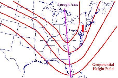
I see the term "trough" a lot in Hurricane discussions and, I understand that the term refers to a mass of air intruding into another air mass composed of different air. So this intrusion is represented on the two dimensional maps that we use with lines that look like a trough, or maybe, a valley or ridge, if we want to use land maps terminology.
What I'm not sure of is whether any particular "trough" is always a low pressure area intruding OR high pressure air mass intruding. Could you tell us more about that, please?What exactly is a "trough"? Thanks.
Posted on 9/10/19 at 2:58 pm to Champagne
quote:
So this intrusion is represented on the two dimensional maps that we use with lines that look like a trough, or maybe, a valley or ridge, if we want to use land maps terminology.
The topographical approach is a good way to see them. Imagine streamlines showing the direction of wind across the land. Consider neutral to be straight W to E. A trough is like a U shape. A ridge an upside down U.
quote:
What I'm not sure of is whether any particular "trough" is always a low pressure area intruding OR high pressure air mass intruding.
A trough is an elongated area of lower pressure. You get them with dips in the jet stream as...
quote:
to a mass of air intruding into another air mass composed of different air.
So hot and cold. Basically cold air from the north diving down and meeting warm air to the south.
The flow around the trough is counterclockwise if you imagine a center at the bottom of the U (well for the Northern Hemisphere at least). Flow goes toward the SE, E, and then NE as it comes around the bottom.
So imagine a storm coming N into the middle of the gulf. A trough is digging in from the NW. The flow around it is going to push a storm to the NE. Put a ridge on the other side, with the flow clockwise around it, it will also push a storm N and NE.
Additionally a trough coming in will "erode" a high pressure system, even if well north of actually turning a storm its self. Which can take steering pushing a storm west to one that's weaker and pushing more N. Typically you'll see this referred to as a "weakness" a storm can follow N and NE.
LINK
Posted on 9/10/19 at 4:35 pm to Duke
Wave north of the Greater Antilles is now 95 L.
Posted on 9/10/19 at 5:07 pm to lsuman25
18Z for 95L (1:00 pm CDT) Tuesday
21.7 N. 72.0 W : Press: 1014 mb ( 29.94 in Hg).
Max winds in disturbance : 25 knots (29 mph)
Distance Of disturbance from Mobile, Alabama 1,168 Miles.
Distance of disturbance from New Orleans: 1,254 Miles.
21.7 N. 72.0 W : Press: 1014 mb ( 29.94 in Hg).
Max winds in disturbance : 25 knots (29 mph)
Distance Of disturbance from Mobile, Alabama 1,168 Miles.
Distance of disturbance from New Orleans: 1,254 Miles.
This post was edited on 9/10/19 at 5:16 pm
Posted on 9/10/19 at 6:54 pm to rds dc
95L is on the board (this took 95L before the wave coming off Africa could, so that will by 96L)
Tropical Weather Outlook
NWS National Hurricane Center Miami FL
800 PM EDT Tue Sep 10 2019
For the North Atlantic...Caribbean Sea and the Gulf of Mexico:
1. A surface trough located over the Turks and Caicos is producing
widespread cloudiness and disorganized thunderstorms over the Turks
and Caicos and the southeastern Bahamas, and extending northward
over the southwestern Atlantic for a few hundred miles. Ship reports
indicate that tropical-storm-force wind gusts are occurring in some
of the heavier squalls. Limited development of this disturbance is
expected during the next few days while the system moves slowly
west-northwestward across the Bahamas due to only marginally
conducive upper-level winds. However, environmental conditions could
become more favorable for development when the system moves over the
Florida Straits and into the eastern Gulf of Mexico late this week
and over the weekend. Regardless of development, this disturbance
will produce periods of locally heavy rainfall and gusty winds
across the Bahamas through Thursday, and across Florida on Friday
and continuing into the weekend.
* Formation chance through 48 hours...low...10 percent.
* Formation chance through 5 days...medium...40 percent.
18z GEFS

Posted on 9/10/19 at 6:58 pm to rds dc
goddamnit
Posted on 9/10/19 at 6:58 pm to rds dc
12z Euro EPS, obviously a more southern track would give any potential system more time over the Gulf and less land interaction.


Posted on 9/10/19 at 6:59 pm to rds dc
Booooo.

 Page 9 of 30

Popular
Back to top