




 1
1





- My Forums
- Tiger Rant
- LSU Recruiting
- SEC Rant
- Saints Talk
- Pelicans Talk
- More Sports Board
- Fantasy Sports
- Golf Board
- Soccer Board
- O-T Lounge
- Tech Board
- Home/Garden Board
- Outdoor Board
- Health/Fitness Board
- Movie/TV Board
- Book Board
- Music Board
- Political Talk
- Money Talk
- Fark Board
- Gaming Board
- Travel Board
- Food/Drink Board
- Ticket Exchange
- TD Help Board
Customize My Forums- View All Forums
- Show Left Links
- Topic Sort Options
- Trending Topics
- Recent Topics
- Active Topics
Started By
Message
Posted on 10/9/26 at 2:18 pm to Sput
You guys please be safe. We evacuated from Pensacola to Valdosta
Posted on 10/9/26 at 2:18 pm to SippyCup
(no message)
This post was edited on 10/9/26 at 2:19 pm
Posted on 10/9/26 at 2:18 pm to gaetti15
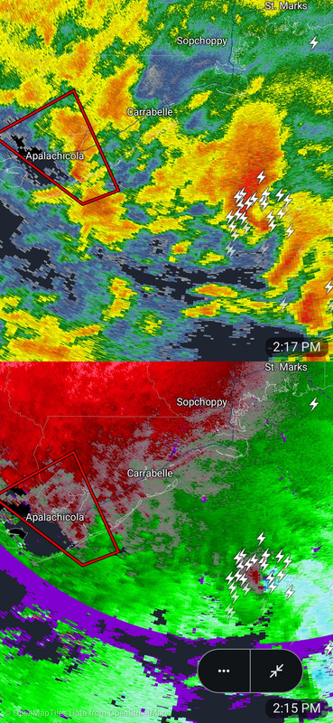
The one to the east will be next. Nasty.
Posted on 10/9/26 at 2:21 pm to rds dc
If the track of this storm takes the eastern eye wall over the area of 30A in south Walton County, I think people will be very unpleasantly surprised at the extent of coastal residential structural wind damage.
Posted on 10/9/26 at 2:21 pm to LegendInMyMind
Might as well be a super cell.
Posted on 10/9/26 at 2:22 pm to Ten Bears
quote:
DeSantis just said storm to hit around 10-11pm tonight. Landfall will be east of Pensacola as a Cat 3
All the radars im seeing are showing 6:30pm -8ish landfall for the eye. It seems to be booking 14-17mph
This post was edited on 10/9/26 at 2:23 pm
Posted on 10/9/26 at 2:22 pm to LegendInMyMind
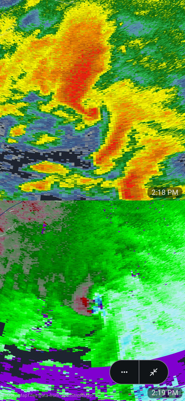
Damn that is nasty
Posted on 10/9/26 at 2:24 pm to GEAUXT
Anyone from Crawfordville, Woodville, up to Tallahassee is going to have to watch it closely.
Posted on 10/9/26 at 2:25 pm to LegendInMyMind
Damn are we in the gulf or Kansas with that radar shot
Posted on 10/9/26 at 2:25 pm to Traffic Circle
quote:
Oh, you are one of ‘those’ people who talk about Gulf Breeze ‘proper’ lol
Fuggin Breezer trash
Posted on 10/9/26 at 2:25 pm to beachdude
quote:
If the track of this storm takes the eastern eye wall over the area of 30A in south Walton County, I think people will be very unpleasantly surprised at the extent of coastal residential structural wind damage.
Why 30A? I would think the damage would be significant along wherever it ultimately lands. I would think the majority of 30A would sustain this better than Ft Walton as the homes are newer and built to hurricane code.
Posted on 10/9/26 at 2:26 pm to baldona
quote:
All the radars im seeing are showing 6:30pm -8ish landfall for the eye. It seems to be booking 14-17mph
Yeah. It is 105 miles from the barrier islands. So right about 6 hours at 17 mph. ~8:30 PM CDT or maybe 7:30 or 8:00 if it speeds up more.
Desantis was probably going by EDT so he was saying 9 or 10 CDT which is a little later than what it will likely be - at least for the barrier islands.
Posted on 10/9/26 at 2:26 pm to LegendInMyMind
quote:
Anyone from Crawfordville, Woodville, up to Tallahassee is going to have to watch it closely.
Google radar from Mike’s weather page is showing it drifting more and the eye maybe going more over the east side of 30a/ Inlet beach area potentially around 8pm
Posted on 10/9/26 at 2:27 pm to baldona
Nope
Posted on 10/9/26 at 2:28 pm to beachdude
quote:
If the track of this storm takes the eastern eye wall over the area of 30A in south Walton County, I think people will be very unpleasantly surprised at the extent of coastal residential structural wind damage.
Yep
Tons of trees in that area that havent been hit by a significant storm in a long time
And way more development now compared to Opal which largely spared 30A
Posted on 10/9/26 at 2:28 pm to baldona
quote:
Google radar from Mike’s weather page is showing it drifting more and the eye maybe going more over the east side of 30a/ Inlet beach area potentially around 8pm
I'm referring to the tornadic cell working its way onshore in a band.
Posted on 10/9/26 at 2:28 pm to Funky Tide 8
quote:youre cool bro, so long as it keeps drifting eastward
I'm getting a bit anxious.
finished up all my prep, got a shower & a shave, got an almost full bottle of good bourbon, about ready to ride this big bag of bad wind

Posted on 10/9/26 at 2:29 pm to baldona
Look at that couplet.
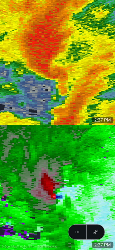
It is probably sucking up some fish right about now.
It is still producing massive amounts of lightning.
It is probably sucking up some fish right about now.
It is still producing massive amounts of lightning.
This post was edited on 10/9/26 at 2:32 pm
Posted on 10/9/26 at 2:31 pm to LegendInMyMind
Second image looks like a vag

 Page 140 of 142



Popular
Back to top
 Follow TigerDroppings for LSU Football News