- My Forums
- Tiger Rant
- LSU Recruiting
- SEC Rant
- Saints Talk
- Pelicans Talk
- More Sports Board
- Fantasy Sports
- Golf Board
- Soccer Board
- O-T Lounge
- Tech Board
- Home/Garden Board
- Outdoor Board
- Health/Fitness Board
- Movie/TV Board
- Book Board
- Music Board
- Political Talk
- Money Talk
- Fark Board
- Gaming Board
- Travel Board
- Food/Drink Board
- Ticket Exchange
- TD Help Board
Customize My Forums- View All Forums
- Show Left Links
- Topic Sort Options
- Trending Topics
- Recent Topics
- Active Topics
Started By
Message
re: Hurricane Irma - Spinning Down
Posted on 9/9/17 at 3:54 pm to heatom2
Posted on 9/9/17 at 3:54 pm to heatom2
quote:
So the way I understand it, the center of the cone is the probable track. The reason for the cone is to account for the historical error in forecasting atlantic hurricanes. If error occurs, and the center of the storm moves to one side of the cone or the other, when they release the updated cone, it is then adjusted to show a new probable track.
Is that even close to how it works?
Yes, but they release a new cone every 3 hours, even they nailed it the previous time. The cone is 120 hours of projections, so 3 hours later, they need to add to the end of the projection.
The cone HAS to shrink based on their methodology - the margin for error at 48 hours is less than the margin at 72 hours. The tail end of the cone will always change as they add hours to the new forecast.
If you look at the cone in this link, you can isolate any of the previous 42 or so projections, then check it against the actual location of Irma 120 hours later. You'll notice she's always inside of the cone from 120 hours ago.
 2
2

Posted on 9/9/17 at 3:54 pm to Old Money
quote:
My parents hunkered down at home. Just had a tornado steam by close to the house a few miles away
Jesus man. Where are they? They are going to be in for a long night.

Posted on 9/9/17 at 3:55 pm to LaBR4
Tornado Warning
CIty of Weston
CIty of Weston

Posted on 9/9/17 at 3:55 pm to LaBR4
quote:
what city?
Weston, FL. They'll be fine

Posted on 9/9/17 at 3:55 pm to tgrbaitn08
This erica navarro chick is thick but bangable

Posted on 9/9/17 at 3:55 pm to slackster
quote:
Yes, but they release a new cone every 3 hours, even they nailed it the previous time. The cone is 120 hours of projections, so 3 hours later, they need to add to the end of the projection.
The cone HAS to shrink based on their methodology - the margin for error at 48 hours is less than the margin at 72 hours. The tail end of the cone will always change as they add hours to the new forecast.
If you look at the cone in this link, you can isolate any of the previous 42 or so projections, then check it against the actual location of Irma 120 hours later. You'll notice she's always inside of the cone from 120 hours ago
Thats how I understood it to work. I'm not so good with the words though. Thanks man.
Posted on 9/9/17 at 3:56 pm to tgrbaitn08


Posted on 9/9/17 at 3:57 pm to ihometiger
quote:
All that water is now headed to Florida (Dramatic video of water retreat from Bahamas islands)
Posted on 9/9/17 at 3:57 pm to heatom2
No problem.
Posted on 9/9/17 at 3:57 pm to Cosmo
quote:
This erica navarro chick is thick but bangable
You back off my woman baw.
Posted on 9/9/17 at 3:58 pm to ihometiger
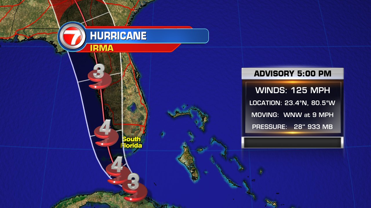
4PM Adv
125 mph
Cat 3
933 mb
WNW @ 9 mph
Next Adv 7pm CST
125 mph
Cat 3
933 mb
WNW @ 9 mph
Next Adv 7pm CST
Posted on 9/9/17 at 3:58 pm to ihometiger
quote:
All that water is now headed to Florida (Dramatic video of water retreat from Bahamas islands)
The comments in that video are hilarious. Someone said the guy needs to take cover because a storm surge is on the way. She obviously thinks it is a tsunami.
Posted on 9/9/17 at 3:58 pm to heatom2
...EYE OF IRMA BEGINNING TO MOVE SLOWLY AWAY FROM THE COAST OF CUBA WHILE WEATHER IS DETERIORATING IN SOUTH FLORIDA... ...MAJOR HURRICANE FORCE WINDS EXPECTED OVER THE FLORIDA KEYS AT DAYBREAK...
5:00 PM EDT Sat Sep 9
Location: 23.4°N 80.5°W
Moving: WNW at 9 mph
Min pressure: 933 mb
Max sustained: 125 mph
5:00 PM EDT Sat Sep 9
Location: 23.4°N 80.5°W
Moving: WNW at 9 mph
Min pressure: 933 mb
Max sustained: 125 mph
Posted on 9/9/17 at 3:58 pm to 50_Tiger
quote:
Tornado Warning CIty of Weston
Never expected to see my little hometown on TD.

Posted on 9/9/17 at 3:58 pm to GeorgeTheGreek
quote:Exactly the question I was asking my dad last night
Again, here's my problem with the cone. If the cone says here's the central track and here are the outermost boundaries of that track ...... then shouldn't the track just move within the cone?
What's the point of a cone, if the whole cone moves?
Posted on 9/9/17 at 3:58 pm to loogaroo

Posted on 9/9/17 at 3:58 pm to heatom2
Posted on 9/9/17 at 4:00 pm to LaBR4
I'm surprised there are still shore birds in the sand at Naples. I didn't see gulls, but weren't there sandpipers?
Posted on 9/9/17 at 4:01 pm to 91TIGER
Those people in the Keys are ridiculous for staying.
Posted on 9/9/17 at 4:01 pm to slackster
NHC bad news:
NHC Good news for this thread:
quote:
Data from a NOAA Hurricane Hunter plane sampling Irma indicate
that the hurricane has not recovered yet from its interaction
with Cuba. It is estimated that the maximum winds are 110 kt. Given
the excellent satellite presentation, the lower pressure just
reported by the NOAA plane, and the fact that the hurricane will
move over the warm waters of the Straits of Florida, some
intensification is anticipated during the next 24 hours. Irma is
expected to remain a very dangerous hurricane while it moves near or
over the Florida Keys and near or over the Florida Peninsula. After
48 hours, Irma will be moving farther inland and weakening.
NHC Good news for this thread:
quote:
Radar data indicate that Irma is moving toward the west-northwest
at about 8 kt. The turn toward the northwest and north-northwest is
about to begin since the hurricane is already at the western edge of
the subtropical ridge. The track guidance continues to be tightly
packed, and the bulk of the models take the hurricane over the
Florida Keys and near or over the Florida Peninsula. The NHC
forecast is in the middle of the guidance envelope, and given the
good agreement among models, the confidence in the track forecast is high.
This post was edited on 9/9/17 at 4:02 pm

 Page 580 of 711

Popular
Back to top