- My Forums
- Tiger Rant
- LSU Recruiting
- SEC Rant
- Saints Talk
- Pelicans Talk
- More Sports Board
- Fantasy Sports
- Golf Board
- Soccer Board
- O-T Lounge
- Tech Board
- Home/Garden Board
- Outdoor Board
- Health/Fitness Board
- Movie/TV Board
- Book Board
- Music Board
- Political Talk
- Money Talk
- Fark Board
- Gaming Board
- Travel Board
- Food/Drink Board
- Ticket Exchange
- TD Help Board
Customize My Forums- View All Forums
- Show Left Links
- Topic Sort Options
- Trending Topics
- Recent Topics
- Active Topics
Started By
Message
re: Hurricane Irma - Spinning Down
Posted on 9/9/17 at 4:01 pm to real turf fan
Posted on 9/9/17 at 4:01 pm to real turf fan
 2
2

Posted on 9/9/17 at 4:02 pm to slackster
quote:This seems to be where some people get hung up.
the margin for error
They want exact or nothing several days in advance.
That's the best technology we have now and much better than anything before.
Like I said earlier, we had 2 tv channels when I was a kid and they seemed to use their gut feelings....and that was mostly landfall., the forerunner to the cone.
I'm not sure why they want to get on some guys that understand some of this and pass it on to us.
If people were completely trained in meteorology I would think they would be working somewhere instead of putting up with dickheads.
This post was edited on 9/9/17 at 4:07 pm
Posted on 9/9/17 at 4:03 pm to ihometiger
quote:
1. Irma is expected bring life-threatening wind and storm surge to
the Florida Keys and southwestern Florida as an extremely dangerous
major hurricane tonight through Saturday. Preparations in southwest
Florida should be completed within the next few hours, as
tropical-storm-force winds are expected to begin tonight.
2. There is an imminent danger of life-threatening storm surge
flooding in portions of central and southern Florida, including the
Florida Keys, where a Storm Surge Warning is in effect. The threat
of catastrophic storm surge flooding is highest along the southwest
coast of Florida, where 10 to 15 feet of inundation above ground
level is expected. This is a life-threatening situation, and
everyone in these areas should immediately follow any evacuation
instructions from local officials.
3. Irma will bring life-threatening wind impacts to much of Florida
regardless of the exact track of the center. Wind hazards from Irma
are also expected to spread northward through much of Georgia
and portions of South Carolina and Alabama.
4. Irma is expected to produce very heavy rain and inland flooding.
Total rain accumulations of 10 to 20 inches, with isolated amounts
of between 20 and 25 inches, are expected over the Florida Keys, the
Florida peninsula, and southeast Georgia from Saturday through
Monday. Significant river flooding is possible in these areas. Early
next week Irma will also bring periods of heavy rain to much of the
southeast United States where an average of 2 to 6 inches is
forecast, with isolated higher amounts, from North and South
Carolina to Tennessee and eastern Alabama. This includes some
mountainous areas which are more prone to flash flooding. Residents
throughout the southeast states should remain aware of the flood
threat and stay tuned to forecasts and warnings.
Posted on 9/9/17 at 4:03 pm to 50_Tiger
quote:
4PM Adv
125 mph
Cat 3
933 mb
WNW @ 9 mph
Next Adv 7pm CST
Question for anyone.
Now that it's on mainland radar, is there any reliable source of wind speed estimates on a realtime basis, i.e., not have to wait for NHC advisories. Also, is there any site that reports observed ground level wind speeds for various local reporting authorities?

Posted on 9/9/17 at 4:04 pm to ihometiger
Posted on 9/9/17 at 4:07 pm to ihometiger
quote:
The Brainsurgeon who decided to take pictures in Key West during Irma
Posted on 9/9/17 at 4:07 pm to Tiger in NY
There is an idiot Gary Humphries live streaming on FB from Key West that is going to ride the storm out in an outside stairwell at a school.
LINK
LINK

Posted on 9/9/17 at 4:08 pm to shawnlsu
(no message)
This post was edited on 9/9/17 at 4:19 pm
Posted on 9/9/17 at 4:08 pm to wdhalgren
quote:
Now that it's on mainland radar, is there any reliable source of wind speed estimates on a realtime basis,
On radar, no, because it's looking into the air and not making surface observations.
quote:
Also, is there any site that reports observed ground level wind speeds for various local reporting authorities?
Yes, there is. LINK
Posted on 9/9/17 at 4:09 pm to slackster
I feel validated in my "gonna go more west than anticipated" guess last night 
This post was edited on 9/9/17 at 4:10 pm

Posted on 9/9/17 at 4:09 pm to The Dudes Rug
She looks good, I really think there will be an explosion in strength after she makes her move north across the Florida Straits.
(Before anyone accuses me of pulling for this to happen, which I was accused of last night, I am not hoping for this but I am just stating my thoughts on what we may see happen)

(Before anyone accuses me of pulling for this to happen, which I was accused of last night, I am not hoping for this but I am just stating my thoughts on what we may see happen)
Posted on 9/9/17 at 4:10 pm to rbWarEagle
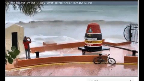
quote:
Storm surge in Key West
I'm a little skeptical of that video. Seems to severe for their current conditions.
Posted on 9/9/17 at 4:10 pm to TigerTatorTots
quote:
What's the point of a cone, if the whole cone moves?
To show you the historic error of these predictions at certain times out. It's to remind people the track won't be perfect; therefore, people should consider themselves at risk for a direct hit if in the cone. If the path changes, the cone will too as it represents the error bounds (which are only 1 SD for the record) of a path.
Posted on 9/9/17 at 4:10 pm to Roll Tide Ravens
5pm EDT, 4pm CDT advisory track:

Posted on 9/9/17 at 4:11 pm to shawnlsu
Can you not watch the feed if you don't have a Facebook?
Posted on 9/9/17 at 4:11 pm to slackster
Does it?

Posted on 9/9/17 at 4:11 pm to rbWarEagle
My word that wave action is INSANE.
Posted on 9/9/17 at 4:11 pm to slackster
quote:This is why the cone means something.
Irma is expected to produce very heavy rain and inland flooding.
People focus on the eye like this is a tornado.
I've been on both sides and in the eye of these things.
When you are on the ground the eye is irrelevant.
Katrina eye went over N.O.east. shite was tore up east of Biloxi.
I saw houses blew apart in Gulfport.

Posted on 9/9/17 at 4:11 pm to Roll Tide Ravens
Parents face-timing me, they live on a lake and you can see shite people didn't bolt down just skating across
This post was edited on 9/9/17 at 4:12 pm
Posted on 9/9/17 at 4:11 pm to slackster
Thanks for all your information and data, it's very helpful.

 Page 581 of 711

Popular
Back to top