- My Forums
- Tiger Rant
- LSU Recruiting
- SEC Rant
- Saints Talk
- Pelicans Talk
- More Sports Board
- Fantasy Sports
- Golf Board
- Soccer Board
- O-T Lounge
- Tech Board
- Home/Garden Board
- Outdoor Board
- Health/Fitness Board
- Movie/TV Board
- Book Board
- Music Board
- Political Talk
- Money Talk
- Fark Board
- Gaming Board
- Travel Board
- Food/Drink Board
- Ticket Exchange
- TD Help Board
Customize My Forums- View All Forums
- Show Left Links
- Topic Sort Options
- Trending Topics
- Recent Topics
- Active Topics
Started By
Message

 2
2

Posted on 9/9/17 at 12:37 am to Clyde Tipton
quote:
frick it. I'll drink another.
This is why I thought I wouldn't make the 1am run. Liver doing work tonight
Posted on 9/9/17 at 12:38 am to 50_Tiger
quote:
because of #ratchetstraps
Those looked shitty too tho
Posted on 9/9/17 at 12:38 am to Thib-a-doe Tiger
Guess I'm going to have to go watch the white shed now so I can learn what the straps are about.
Posted on 9/9/17 at 12:39 am to rbWarEagle
quote:
Does it look like it's still at Cat5? I'm looking at a couple of radar images that appear to show it getting beat up on the Southeast quadrant.
No, I doubt she's supporting Cat 5 winds at this time. West side looks worse for wear after spinning so close on Cuba. I'd expect her to look better as the night goes on and gets more of the coast of Cuba, but it'll be a slow runout.

Posted on 9/9/17 at 12:39 am to LSUGrrrl
quote:
I was headed to bed an hour ago. Guess I'll pour another glass and wait it out again.
Question: since the northern shift just happened, how much will it factor into Euro?
Channeling my inner slack/rds/rummy
I am guessing she's too close now for it to matter as much. The pressure readings have been off a bit on most of the runs.
At this point im paying more attention to recon flights.
I am pretty confident she will make that turn sooner rather than later.
Posted on 9/9/17 at 12:41 am to 50_Tiger
Slackster and the rest of the crew closely following this and explaining the info for those of us with little or minimal meteorological knowledge,,,,you have been excellent tonight.

Posted on 9/9/17 at 12:42 am to texag7
Saw an interview earlier today from one of those NWS guys pictured on the Keys. The building as a whole is CAT 4 surge and wind hardened for a long duration event like Irma. There is an interior "safe room" that is CAT 5 safe, and they mentioned a backup plan. I don't know how all that works. I'm sure they will tweet about it.
Posted on 9/9/17 at 12:42 am to Chadaristic
quote:
I care less about my big screen tv than I do my wife's wedding dress. I can assure you that she didn't anticipate losing it this way.
Things you treasure but can't take with you, put them in garbage bags and close them up in your dishwasher if they will fit. There's a good chance they will survive, even if the dishwasher is found 200 yards from the remains of the house. I grew up in Biloxi, and yes, I'm serious.

Posted on 9/9/17 at 12:42 am to Duke
quote:
No, I doubt she's supporting Cat 5 winds at this time. West side looks worse for wear after spinning so close on Cuba. I'd expect her to look better as the night goes on and gets more of the coast of Cuba, but it'll be a slow runout.
Well... guess that half bottle of Basil Hayden is taking a hit this evening.
Posted on 9/9/17 at 12:43 am to LSUGrrrl
quote:
since the northern shift just happened, how much will it factor into Euro?
Little. Some bouncing is expected with the land interaction and will tend to smooth out over time. The things steering her are what matter and we watch (well if I don't fall asleep) to see if it's picked up on any major changes in that.

Posted on 9/9/17 at 12:45 am to slackster
quote:
This conversation has been hashed and rehashed many times in this thread. Suffice to say that Buras and the eastern parts of LA were always in that uncertainty cone.
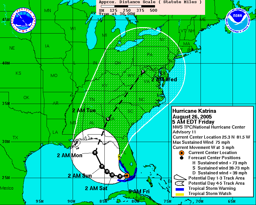
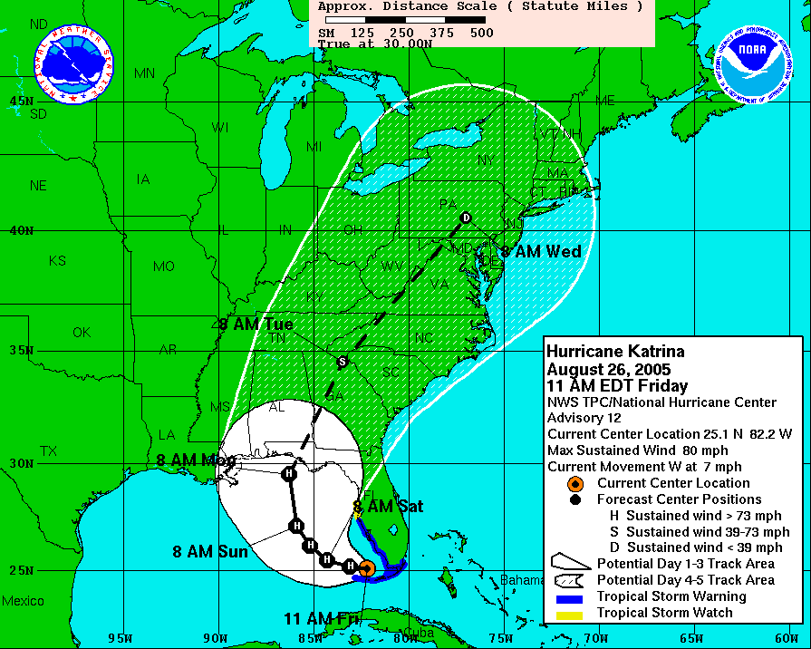
Dizz asked when did experts err. I offered Katrina as an example with some similarities to Irma.
I am not sure what rehashed conversation you are writing about not having read all of the 10 or 11 thousand posts in this thread.
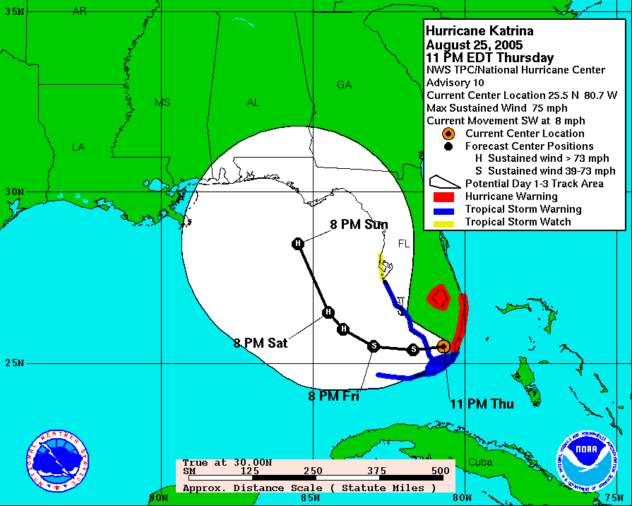
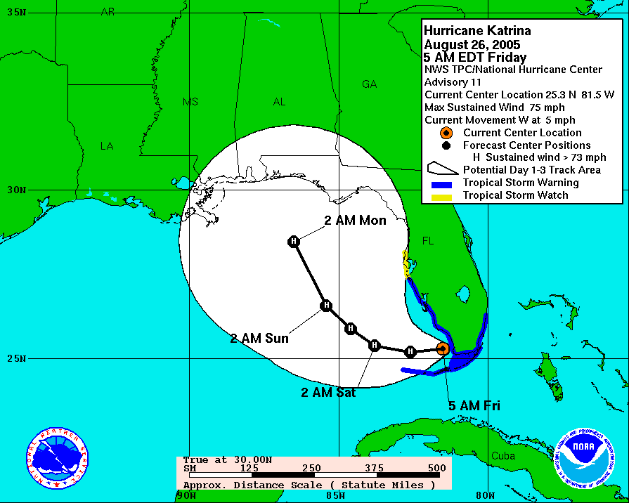
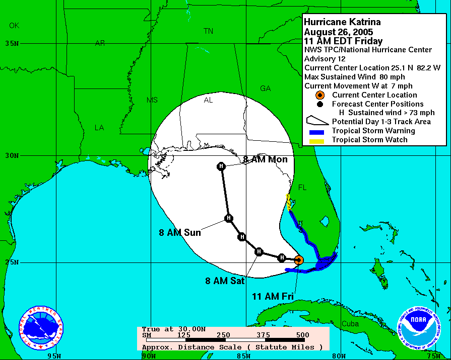
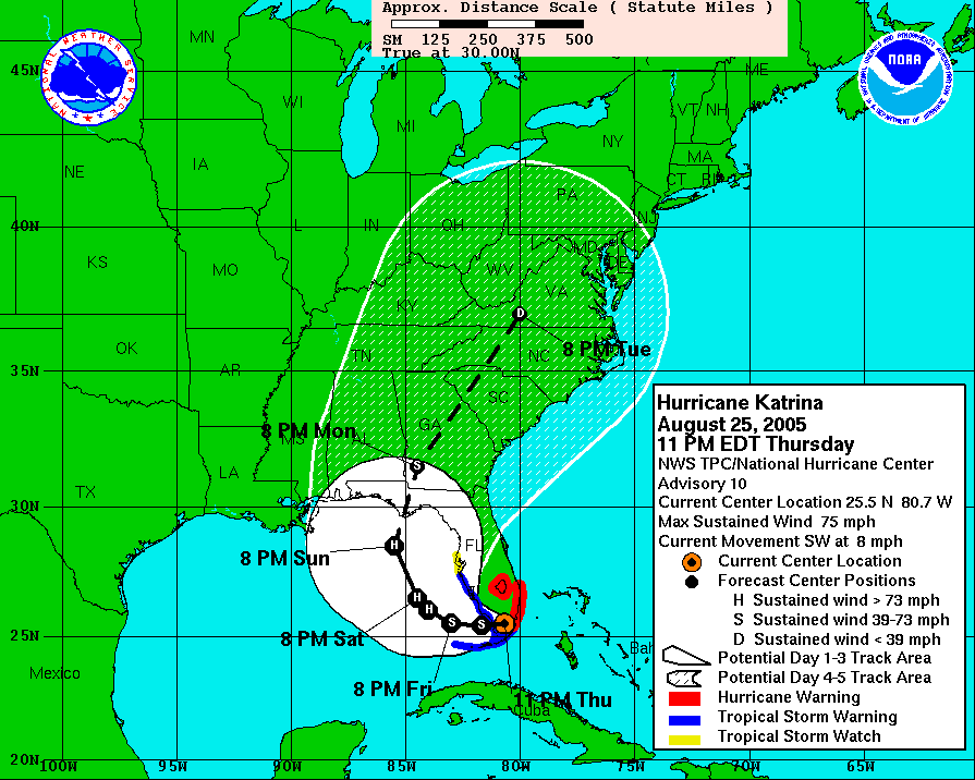
To state that Buras and eastern LA were always in the cone is misleading and a little inaccurate. Southeastern LA (really just the mouth of the River) only came into the cone in the 11 pm Thursday advisory and then only at the far western margin of the cone. It stayed in the far western margins of the cone through the 5 am Friday and the 11 am Friday advisory. The dramatic shift did not appear until the 5 pm Friday advisory and moved further west by 11 pm Friday. This is using the three day cones as a warning tool. If you look at the 5 day cones, the suggestion that a hurricane would make landfall well to the west of LA/MS was more pronounced. The relevant graphics are below.
None of this is a criticism of the forecasters or their models. It was over twelve years ago using less sophisticated models and satellite tools. Having said that, it is not all that dissimilar to today where the models are saying one thing and the cyclone has not done what was expected yet.
Posted on 9/9/17 at 12:46 am to Duke
It's definitely riding the coast of Cuba but WNW trend looks fairly strong.
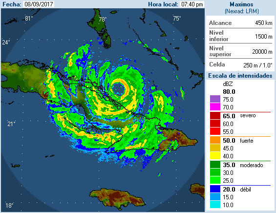
ETA: this looks more NW...
I just hope Cuba shreds her for a few more hours.
ETA: this looks more NW...
I just hope Cuba shreds her for a few more hours.
This post was edited on 9/9/17 at 12:50 am
Posted on 9/9/17 at 12:46 am to Duke
Duke im reading the Vortex data from AF308.
Me thinks 1am will bring her back down to CAT 4 (150mph)
Product: Air Force Vortex Message (URNT12 KNHC)
Transmitted: 9th day of the month at 5:36Z
Agency: United States Air Force
Aircraft: Lockheed WC-130J Hercules with reg. number AF98-5308
Storm Number & Year: 11 in 2017
Storm Name: Irma (flight in the North Atlantic basin)
Mission Number: 24
Observation Number: 19 ( See all messages of this type for this mission. )
A. Time of Center Fix: 9th day of the month at 5:11:40Z
B. Center Fix Coordinates: 22°15'N 78°05'W (22.25N 78.0833W)
B. Center Fix Location: 60 statute miles (97 km) to the N (349°) from Camagüey, Cuba.
C. Minimum Height at Standard Level: 2,501m (8,205ft) at 700mb
D. Estimated (by SFMR or visually) Maximum Surface Wind Inbound: 131kts (~ 150.8mph)
E. Location of the Estimated Maximum Surface Wind Inbound: 13 nautical miles (15 statute miles) to the ENE (74°) of center fix
F. Maximum Flight Level Wind Inbound: From 158° at 124kts (From the SSE at ~ 142.7mph)
G. Location of Maximum Flight Level Wind Inbound: 23 nautical miles (26 statute miles) to the ENE (71°) of center fix
H. Minimum Sea Level Pressure: 931mb (27.50 inHg)
I. Maximum Flight Level Temp & Pressure Altitude Outside Eye: 11°C (52°F) at a pressure alt. of 3,053m (10,016ft)
J. Maximum Flight Level Temp & Pressure Altitude Inside Eye: 17°C (63°F) at a pressure alt. of 3,048m (10,000ft)
K. Dewpoint Temp & Sea Surface Temp (collected at same location as temp inside eye): Not Available
L. Eye Character: Closed
M. Eye Shape & Diameter: Circular with a diameter of 28 nautical miles (32 statute miles)
N. Fix Determined By: Penetration, Radar, Wind, Pressure and Temperature
N. Fix Level: 700mb
O. Navigational Fix Accuracy: 0.02 nautical miles
O. Meteorological Accuracy: 3 nautical miles
Remarks Section:
Maximum Flight Level Wind: 124kts (~ 142.7mph) which was observed 23 nautical miles (26 statute miles) to the ENE (71°) from the flight level center at 5:04:00Z
Dropsonde Surface Wind at Center: From 205° at 11kts (From the SSW at 13mph)
Maximum Flight Level Temp: 18°C (64°F) which was observed 7 nautical miles to the W (279°) from the flight level center
This post was edited on 9/9/17 at 12:50 am
Posted on 9/9/17 at 12:48 am to Rambler
Washing machine (front load) is very good for this, too.
Posted on 9/9/17 at 12:51 am to rbWarEagle
It looks NW but the dip before that basically leaves it at the same latitude as it was previously.
I don't know what that means for long term movement. Recovering from a wobble or new direction?
I don't know what that means for long term movement. Recovering from a wobble or new direction?
Posted on 9/9/17 at 12:52 am to 50_Tiger
I'm with you. Wall looks strong but significantly more localized to a smaller area. Cuba doing more damage than I thought it would.
Posted on 9/9/17 at 12:53 am to rbWarEagle
quote:
I'm with you. Wall looks strong but significantly more localized to a smaller area. Cuba doing more damage than I thought it would.
Yeah Irma looks like she is having issues on the Western front.
Can she possibly pull a Falcons?
Posted on 9/9/17 at 12:53 am to Thib-a-doe Tiger
quote:
It looks NW but the dip before that basically leaves it at the same latitude as it was previously.
I don't know what that means for long term movement. Recovering from a wobble or new direction?
Good question. Guess we'll have to wait until 2 to find out.
Posted on 9/9/17 at 12:54 am to rbWarEagle
1 AM CST is out
WOW they did NOT downgrade her.
160 MPH CAT 5
930 mb
W @ 12
Next Adv 4 CST
WOW they did NOT downgrade her.
160 MPH CAT 5
930 mb
W @ 12
Next Adv 4 CST

 Page 531 of 711

Popular
Back to top