- My Forums
- Tiger Rant
- LSU Recruiting
- SEC Rant
- Saints Talk
- Pelicans Talk
- More Sports Board
- Coaching Changes
- Fantasy Sports
- Golf Board
- Soccer Board
- O-T Lounge
- Tech Board
- Home/Garden Board
- Outdoor Board
- Health/Fitness Board
- Movie/TV Board
- Book Board
- Music Board
- Political Talk
- Money Talk
- Fark Board
- Gaming Board
- Travel Board
- Food/Drink Board
- Ticket Exchange
- TD Help Board
Customize My Forums- View All Forums
- Show Left Links
- Topic Sort Options
- Trending Topics
- Recent Topics
- Active Topics
Started By
Message

 0
0


Posted on 11/2/20 at 8:01 pm to MrLSU
quote:
The island is San Andres
I don’t think that is San Andres. I think it is Cayo Mayor.
This post was edited on 11/2/20 at 8:02 pm
Posted on 11/2/20 at 8:02 pm to fightin tigers
There’s going to a be a lot of live lost down there with this storm. You can take out half a village with rotor wash down there.

Posted on 11/2/20 at 8:03 pm to Roll Tide Ravens
It just got or is getting sterilized.
I noticed most of those islands have a nice baseball diamond.
I noticed most of those islands have a nice baseball diamond.
This post was edited on 11/2/20 at 8:07 pm

Posted on 11/2/20 at 8:06 pm to Roll Tide Ravens

Posted on 11/2/20 at 8:07 pm to Roll Tide Ravens
Picture of that island - Miskito Cays (Cayos Miskitos in Spanish) in calmer times


This post was edited on 11/2/20 at 8:12 pm

Posted on 11/2/20 at 8:15 pm to rds dc
Next report should show us...right?
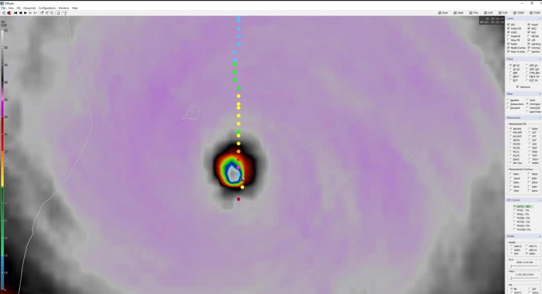
Posted on 11/2/20 at 8:15 pm to rds dc
That's a tight windfield.
Posted on 11/2/20 at 8:16 pm to Duke
quote:
That's a tight windfield
Basically a really big tornado.
Posted on 11/2/20 at 8:22 pm to rds dc
And...927-928 mb. Huh.
Posted on 11/2/20 at 8:22 pm to Duke
Lol Eta trolled us
Posted on 11/2/20 at 8:23 pm to rds dc
What are the chances of this thing heading back out to sea, heading North and hitting Baton Rouge?
Posted on 11/2/20 at 8:25 pm to lsuman25
Posted on 11/2/20 at 8:28 pm to Duke
@jacksillin
@hurricanetrack
quote:
So the first data from #Eta's inner core is suggestive of an intensity below satellite estimates.
However, this is still a ridiculously intense hurricane. Note the 10C temperature spike in the eye! Might find stronger winds in the southwestern eyewall or maybe in later passes. LINK
@hurricanetrack
quote:
Wonder if we will see higher winds in the RFQ relative to the hurricane's movement? So in this case, as you suggest, SW quad may be the strongest?
This post was edited on 11/2/20 at 8:30 pm
Posted on 11/2/20 at 8:29 pm to loogaroo
I thought it was lower than high 920s and more than 150 mph winds.
Posted on 11/2/20 at 8:32 pm to Duke
quote:
I thought it was lower than high 920s and more than 150 mph winds.
It has been doing some wonky wobbling. I wonder if it has tried EWRC, but hasn't been able to get it done, like rds mentioned earlier.
Posted on 11/2/20 at 8:34 pm to Duke
quote:
And...927-928 mb. Huh.
Yep, why recon is superior to all the satellite techniques. Also, could have peaked a couple of hours ago?
Posted on 11/2/20 at 8:35 pm to Duke
Doesn't look like that drop was in the center, either.
Posted on 11/2/20 at 8:39 pm to LegendInMyMind
quote:
Doesn't look like that drop was in the center, either.
Hopefully, they take shorter passes on this mission. The first couple of missions took wide sweeps and only got two center passes before heading out.

 Page 19 of 40

Popular
Back to top