- My Forums
- Tiger Rant
- LSU Recruiting
- SEC Rant
- Saints Talk
- Pelicans Talk
- More Sports Board
- Fantasy Sports
- Golf Board
- Soccer Board
- O-T Lounge
- Tech Board
- Home/Garden Board
- Outdoor Board
- Health/Fitness Board
- Movie/TV Board
- Book Board
- Music Board
- Political Talk
- Money Talk
- Fark Board
- Gaming Board
- Travel Board
- Food/Drink Board
- Ticket Exchange
- TD Help Board
Customize My Forums- View All Forums
- Show Left Links
- Topic Sort Options
- Trending Topics
- Recent Topics
- Active Topics
Started By
Message

 1
1


Posted on 9/4/18 at 10:33 am to CorkSoaker
Posted on 9/4/18 at 10:33 am to deuce985
quote:

That's 250 hours out bro unless the Euro and GFS keep picking up on it nothing to talk about for now.
the 1 that may be worth talking about is that wave behind Florence
that 1 seems to be well south of where Florence started and the models seem to not turn it out to sea... it could be a US problem at some point
Posted on 9/4/18 at 10:35 am to rt3
Yup I mentioned that one yesterday it has a possibility it could drift as far west into the gulf. Still way too early to worry about that one too though.
Looks like Gordon is trying to organize and strengthen again
Looks like Gordon is trying to organize and strengthen again
This post was edited on 9/4/18 at 10:35 am
Posted on 9/4/18 at 10:36 am to deuce985
quote:
Yup I mentioned that one yesterday it has a possibility it could drift as far west into the gulf. Still way too early to worry about that one too though.
Looks like Gordon is trying to organize and strengthen again
of course
but it's at the time where we all got eyes on Gordon... but let's keep that 1 in our peripheral vision for now... so it doesn't just sneak up on anyone
ETA: can we start calling that 1 potential Helene... since it has a 70% chance of developing into a tropical system over the next 5 days
This post was edited on 9/4/18 at 10:38 am
Posted on 9/4/18 at 10:40 am to rt3
What surprises me about the new Invest is that the models keep it running low and going through the Caribbean. Usually when there is a hurricane out front it creates a weakness and leaves an escape route for the storms behind it. This one doesn't appear to feel any weakness and continues on West. Definitely one to watch but it is so far out that there is no telling where it will end up.
Posted on 9/4/18 at 10:40 am to rt3
I am really impressed that the Euro model had Gordon’s path and its projected landfall fairly accurate from 5 days ago.

Posted on 9/4/18 at 10:41 am to BigB0882
Gordan seems to be blowing up but still looks for very lopsided and is hauling arse
Posted on 9/4/18 at 10:44 am to Impotent Waffle
At this rate it has to make landfall by Midnight I would think
Also, Satellite looks real healthy right now
Also, Satellite looks real healthy right now
This post was edited on 9/4/18 at 10:50 am
Posted on 9/4/18 at 10:45 am to Tbonepatron
quote:
Jeff is at it again
Hold onto your beer as you watch
Posted on 9/4/18 at 10:53 am to Impotent Waffle
quote:
Gordan seems to be blowing up but still looks for very lopsided and is hauling arse
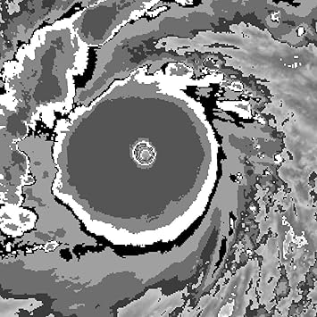
Convection is certainly looking better, but the deepest stuff is still east of the center. It's moving too fast I think to really get the deep stuff wrapped around. It's almost creating it's own shear with this forward motion.

White is deeper convection, the gray in the white deeper still.
Here's an example of a much deeper storm using this type of image:
Posted on 9/4/18 at 10:56 am to Duke
Would you say the storm is heading more north that west in the latest radar frames? (Note I'm trying to guess that from the Weather Channel's tiny arse radar on screen)

Posted on 9/4/18 at 10:57 am to Tbonepatron
quote:
Jeff is at it again
Wishcasting a waterspout...look at the waterspout...well it's not a waterspout, but look at that shear.
"Cat 2 is still on the table, most likely a comes in as a Cat 1"
This post was edited on 9/4/18 at 10:57 am
Posted on 9/4/18 at 10:59 am to deuce985
I’m worried about the storm surge in Mobile. Secured my oyster farm yesterday but it still makes me nervous. Just put 250k seed out there. I don’t want to have to go on a search party for my cages tomm in the middle of the Bay.
Posted on 9/4/18 at 11:01 am to mightynine
quote:
Would you say the storm is heading more north that west in the latest radar frames?
Looks to be on the same heading as earlier per recon fixes. Radar watching for the center is going to be a pain until it gets a little closer, it's so far away from the Mobile station you're getting a view way up in the air.

Posted on 9/4/18 at 11:01 am to LaBR4
Jeff is legit retarded.
Posted on 9/4/18 at 11:02 am to The Boat
quote:
Jeff is legit retarded.
Makes him the perfect storm chaser for the OT.
Posted on 9/4/18 at 11:07 am to rt3
quote:
but it's at the time where we all got eyes on Gordon... but let's keep that 1 in our peripheral vision for now... so it doesn't just sneak up on anyone ETA: can we start calling that 1 potential Helene... since it has a 70% chance of developing into a tropical system over the next 5 days
Posted on 9/4/18 at 11:10 am to slackster
So for Mandeville I'm looking at a little rain and a few wind gusts of about 30 mph, that about it?

Posted on 9/4/18 at 11:11 am to Duke
quote:
Jeff is legit retarded.quote:
Makes him the perfect storm chaser for the OT.


 Page 63 of 400

Popular
Back to top