- My Forums
- Tiger Rant
- LSU Recruiting
- SEC Rant
- Saints Talk
- Pelicans Talk
- More Sports Board
- Fantasy Sports
- Golf Board
- Soccer Board
- O-T Lounge
- Tech Board
- Home/Garden Board
- Outdoor Board
- Health/Fitness Board
- Movie/TV Board
- Book Board
- Music Board
- Political Talk
- Money Talk
- Fark Board
- Gaming Board
- Travel Board
- Food/Drink Board
- Ticket Exchange
- TD Help Board
Customize My Forums- View All Forums
- Show Left Links
- Topic Sort Options
- Trending Topics
- Recent Topics
- Active Topics
Started By
Message
re: Hurricane Florence - Catastrophic Flooding Potential
Posted on 9/12/18 at 8:40 am to Duke

Posted on 9/12/18 at 8:40 am to Duke
What kind of storm was it when they got flooded a few years ago? Something small correct? They also have to deal with mountains so it shouldn’t take as much to flood everything downstream.
 1
1

Posted on 9/12/18 at 8:40 am to 50_Tiger
No, I've got that recon data with a clear double max.
Posted on 9/12/18 at 8:41 am to ell_13
quote:
It shows a lot more than that. A new storm just off the carolinas forms too.
Same with a storm on the pacific side of central america. That gif was nuts.

Posted on 9/12/18 at 8:42 am to Duke
quote:
No, I've got that recon data with a clear double max.
Aye just saw that. I'm a little behind this morning
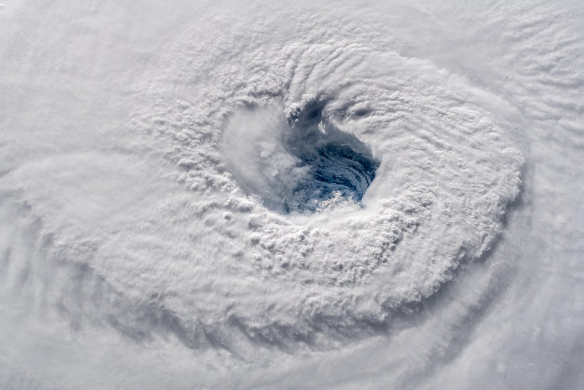
This eye is going to be at least 50nmi at landfall imo

Posted on 9/12/18 at 8:42 am to someLSUdoosh

Posted on 9/12/18 at 8:44 am to bigberg2000
quote:
What kind of storm was it when they got flooded a few years ago? Something small correct? They also have to deal with mountains so it shouldn’t take as much to flood everything downstream.
Matthew got NC a few years back.
Joaquin didn't even landfall but threw a good foot plus of rain across SC.
What's rough this go round is the north side is going to have onshore flow at the river outlets. That'll hamper drainage and enhance the backup.
Posted on 9/12/18 at 8:44 am to GetCocky11
quote:
Chances of strengthening before landfall?
Who knows? Best bet is to follow the NHC updates.

Posted on 9/12/18 at 8:45 am to GermantownTiger
Isn’t that close to wetlands and canals?
I would get ready to go.
16 will be gridlock if this track shifts south again.
I would get ready to go.
16 will be gridlock if this track shifts south again.

Posted on 9/12/18 at 8:46 am to MorbidTheClown
Looks like it is energizing.
Posted on 9/12/18 at 8:46 am to TigerNAtux
Yeah it's very close to waterways
Posted on 9/12/18 at 8:46 am to Duke
Doesnt break into today, but she seems to cycle them out fast.
This post was edited on 9/12/18 at 8:48 am
Posted on 9/12/18 at 8:48 am to GermantownTiger
quote:
Slack, I'm between Savannah and Tybee Island. What do you recommend?
Check the NHC surge map. Otherwise, prepare for a week without power and be ready to leave if things continue to trend that way.
People in Savannah area don't need to go very far to get out of immediate harm's way.
ETA - I mean look, a tree can fall on any house with rain and an 80 mph gust, so if you've got that kind of threat, leave.
This post was edited on 9/12/18 at 8:51 am
Posted on 9/12/18 at 8:49 am to GermantownTiger
Good luck. Never lived there but my daughter is a SCAD grad. So we spent quite a bit of time on Tybee. Love it there.

Posted on 9/12/18 at 8:50 am to MorbidTheClown

Posted on 9/12/18 at 8:51 am to When in Rome
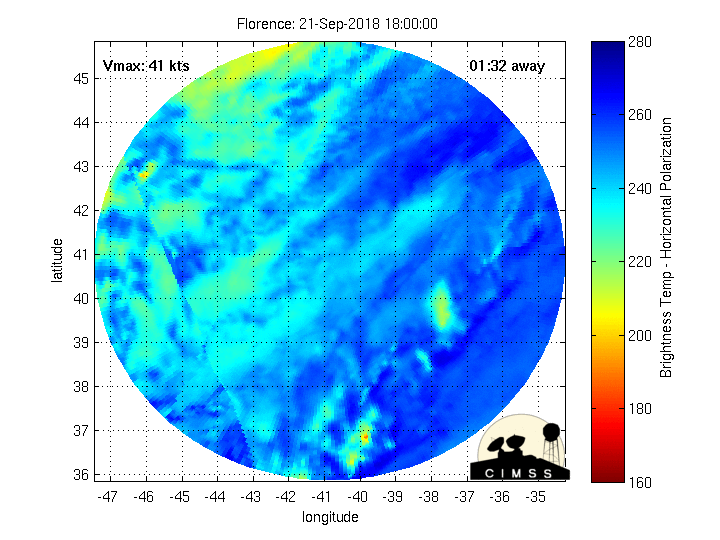
For folks charting:


Posted on 9/12/18 at 8:52 am to slackster
So current area of landfall projection is NC/SC border? Oak Island, NC in trouble I assume.
Posted on 9/12/18 at 8:52 am to When in Rome
BINGO
Posted on 9/12/18 at 8:53 am to TigerNAtux
Appreciate it!
Posted on 9/12/18 at 8:54 am to 50_Tiger
quote:
Doesnt break into today, but she seems to cycle them out fast.
She'll arguably get this one through relatively fast. rds mentioned earlier and it seems true to my eye that she never fully reordered after the first one, so the inner wall is probably a bit "fragile". I'm interested in seeing if that idea shows any truth this morning/pm.
Can't say I'm unhappy to see her waste the best window for strengthening on a EWRC.

Posted on 9/12/18 at 9:00 am to rds dc
quote:
Dr. Ventrice posted the IBM wx model which does show 95L as a TS and Isaac rebounding in the Caribbean.
Does that show 95L forming an eye over land??


 Page 228 of 400

Popular
Back to top