- My Forums
- Tiger Rant
- LSU Recruiting
- SEC Rant
- Saints Talk
- Pelicans Talk
- More Sports Board
- Fantasy Sports
- Golf Board
- Soccer Board
- O-T Lounge
- Tech Board
- Home/Garden Board
- Outdoor Board
- Health/Fitness Board
- Movie/TV Board
- Book Board
- Music Board
- Political Talk
- Money Talk
- Fark Board
- Gaming Board
- Travel Board
- Food/Drink Board
- Ticket Exchange
- TD Help Board
Customize My Forums- View All Forums
- Show Left Links
- Topic Sort Options
- Trending Topics
- Recent Topics
- Active Topics
Started By
Message
re: Hurricane Florence - Catastrophic Flooding Potential
Posted on 9/11/18 at 7:39 am to 50_Tiger
Posted on 9/11/18 at 7:39 am to 50_Tiger
quote:
She gon be a yuugggee bihhh
Wow. HWRF has been on this for days now. Looking like 50 miles (pro from 2k's guess) across. That'll get some attention this afternoon.
 2
2

Posted on 9/11/18 at 7:40 am to 50_Tiger
quote:
Its forward speed will continue to slow down. That's the second biggest issue pre-landfall.

Posted on 9/11/18 at 7:41 am to Duke
143kt flight level wind = Dont eat the cheese folks
Posted on 9/11/18 at 7:41 am to jmcwhrter
quote:
Did I miss something, or did the GFS kill Isaac off into South America?
You're correct. The "GFS" posted earlier is an experimental version.
Posted on 9/11/18 at 7:41 am to slackster
quote:
, her forward speed has actually picked up and will remain pretty constant through the next 72 hours. The slowdown/stall won't happen until then.
You sure bout that? She was moving 13-14mph last night.
Whoops see the 15mph on the latest adv. I stand corrected.
This post was edited on 9/11/18 at 7:43 am
Posted on 9/11/18 at 7:43 am to 50_Tiger
She's still riding around the ridge, it shouldn't change too much in forward speed.

Posted on 9/11/18 at 7:47 am to Duke
Can someone point me to the estimated wind speed maps? Will help me give better suggestions on the travel board thread

Posted on 9/11/18 at 7:49 am to slackster
quote:I removed it so it doesn't create confusion
The "GFS" posted earlier is an experimental version.
Posted on 9/11/18 at 7:50 am to Duke
quote:
EWRC vs dry air
This happens a lot in the Pacific. A storm will go through an ERC and then never fully pull it back together. ERC are still a bit of a mystery and not well understood, with regards to timing and why some are successful and others not.
This post was edited on 9/11/18 at 7:51 am

Posted on 9/11/18 at 7:51 am to CuseTiger

Would this help?
Posted on 9/11/18 at 7:53 am to Duke
quote:
Wow. HWRF has been on this for days now. Looking like 50 miles (pro from 2k's guess) across. That'll get some attention this afternoon.
The HWRF and the EURO pretty much have the same landfall point for Florence. Very similar inland movement too.
Euro and wind gusts:

HWRF at maximum intensity right before landfall:

HMON is also in remarkable agreement at the same hour:

I said it yesterday evening, but Wilmington +/- 50 miles is going to be ground zero.
Posted on 9/11/18 at 7:54 am to rds dc
quote:
This happens a lot in the Pacific. A storm will go through an ERC and then never fully pull it back together. ERC are still a bit of a mystery and not well understood, with regards to timing and why some are successful and others not.
It's a question that has caught my imagination over the years. If life ever has me researching hurricanes, it'd probably be the piece I'd want to focus on.
Posted on 9/11/18 at 7:54 am to ForeverLSU02
quote:
I removed it so it doesn't create confusion
It's a worthwhile thing to use in conjunction with the other models, but it's quite the outlier for Isaac at this point.
Posted on 9/11/18 at 7:55 am to al_cajun
quote:
Is Isaac just nothing to worry about anymore? Is it just going to dissipate?
The overnight models were a bit more aggressive with Isaac and now keep it together into the WCAB vs killing it off pretty quickly after entering the Caribbean.


Posted on 9/11/18 at 7:57 am to rds dc
Euro or GFS doing a better job?
Posted on 9/11/18 at 7:59 am to rds dc
quote:
This happens a lot in the Pacific. A storm will go through an ERC and then never fully pull it back together. ERC are still a bit of a mystery and not well understood, with regards to timing and why some are successful and others no
It's fascinating to see the progress the NHC has made on forecasting locations vs intensity:
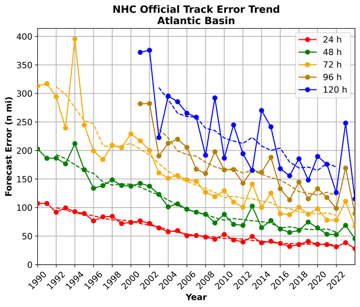
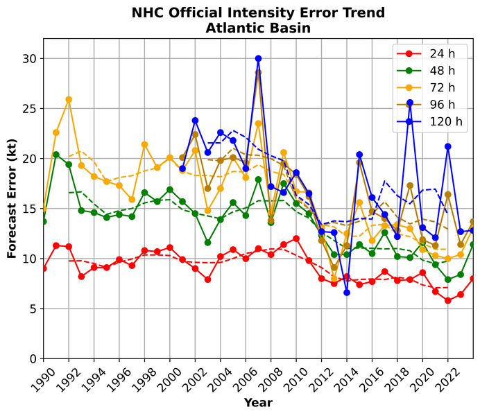
They've cut track errors in half or more over the last 30 years, but intensity projections have shown minimal improvement.
Posted on 9/11/18 at 7:59 am to fightin tigers
Double Post
This post was edited on 9/11/18 at 8:01 am
Posted on 9/11/18 at 8:00 am to fightin tigers
quote:
Euro or GFS doing a better job?
I haven't had time to dig that deep on Isaac but the same issues that are tripping up the GFS with Florence are probably causing the GEFS to have a north turn bias with Isaac.
Posted on 9/11/18 at 8:01 am to rds dc
Completely understandable. Didn't know if one model was significantly more reliable this year.
Seems everything is starting to agree if will go more southerly now.
Seems everything is starting to agree if will go more southerly now.

 Page 185 of 400

Popular
Back to top