- My Forums
- Tiger Rant
- LSU Recruiting
- SEC Rant
- Saints Talk
- Pelicans Talk
- More Sports Board
- Fantasy Sports
- Golf Board
- Soccer Board
- O-T Lounge
- Tech Board
- Home/Garden Board
- Outdoor Board
- Health/Fitness Board
- Movie/TV Board
- Book Board
- Music Board
- Political Talk
- Money Talk
- Fark Board
- Gaming Board
- Travel Board
- Food/Drink Board
- Ticket Exchange
- TD Help Board
Customize My Forums- View All Forums
- Show Left Links
- Topic Sort Options
- Trending Topics
- Recent Topics
- Active Topics
Started By
Message

 1
1

Posted on 9/7/18 at 4:35 pm to Klark Kent
quote:
The tv meteorologists in Houston are flirting with the idea of the thunderstorms down off the coast of Honduras, Nicaragua, and Costa Rica could gather some momentum and churn up a tropical system for Texas. talking mid next week?
It's possible, if it storms long enough over the water it'll eventually close off into a low pressure system. A few models have shown a broad low pressure area show up in the gulf in the timeframe. Not a significant numbers of models develop it and it wouldn't likely be anything major but bring more rain to the area.

Posted on 9/7/18 at 5:34 pm to rds dc
Still a lot of uncertainty with Florence

Posted on 9/7/18 at 5:37 pm to Chad504boy
WTF is that loop? 

Posted on 9/7/18 at 5:42 pm to t00f
Florence looks raggedy as shite

Posted on 9/7/18 at 5:45 pm to BRIllini07
quote:
Over/under on number of "climate change caused this" articles that would come out in the following days if we get back-to-back hits on consecutive days on US Soil: 14,000
Many probably as that's the consensus party line.
I just read an analysis that claimed climate change/global warming (take your pick) is responsible for a higher percentage of extreme hurricanes over the past few years.
I realize that the technology available to provide enhanced satellite imagery, aerial incursions, buoy data and all the rest confirms when a storm reaches the extreme category. The assumption seems to be there are more extreme storms now which coincides with current popular theories respecting global warming. So there must be a direct correlation.
How do they know over that past ages that there weren't just as many extreme hurricanes, or more?
There's dramatic jump in the tools available to the tropical meteorologist in the time between Miller and Dunn's Atlantic Hurricanes (1964 I think) and Simpson and Riehl's The Hurricane and Its Impact (1981), and light years between 1981 and now. The satellite and Doppler radar imagery available now compared to limited radar snapshot images of the late 1940s and 1950s are what the crossbow is to a Predator drone.
Prior to the competent and innovative military meteorologists in the early to mid 20th century, particularly in the WWII Pacific, the most accomplished hurricane forecasters operated in the late 1800s, early 1900s, Issac Kline and Benito Vines, a Cuban priest, both self taught.
The 1900 Galveston hurricane that Kline experienced and suffered great personal tragedy has been deemed a Category 4. Was it? A 5? A 3? Based on damage to wooden structures and anemometers that failed? Estimated storm surge? No satellite imagery or flights from Kessler to confirm. I'm not saying it wasn't a 4. I'd guess it probably was.
We really just don't know for sure whether the many hurricanes which have hit the U.S. coast from its founding and even before have been more or less extreme than those we have experienced in the last 60 years or so.
To assume that the last few decades represent all the previous seems dubious and reflects an agenda looking for "scientific" justification.
IMHO.
Posted on 9/7/18 at 5:45 pm to rt3
quote:
classic misdirection
doomcane incoming
Kinda worries me that they aren’t predicting one
Posted on 9/7/18 at 5:50 pm to t00f
quote:
WTF is that loop?
these storms always throw us for a loop. I have dyslexia so I took that as the storm went for a loop
Posted on 9/7/18 at 5:58 pm to Mr. Misanthrope
Exactly, and throw in the satellite information we get, there isn't much they miss as far as weather goes. The see every little tropical storm no matter how marginal.
Posted on 9/7/18 at 6:03 pm to Chad504boy
quote:
WTF is that loop?
these storms always throw us for a loop. I have dyslexia so I took that as the storm went for a loop
Solid explanation
Posted on 9/7/18 at 6:04 pm to Cosmo
quote:
Florence looks raggedy as shite
Just got back from DC, glad I got the frick out of there.
Posted on 9/7/18 at 6:07 pm to Cosmo
quote:
Florence looks raggedy as shite
The shear monster and cooler waters did their thing.
Shear about to drop as she rolls into that warm current of the western Atlantic so not going to last long.
Happy Hour GFS into NC. Same as before. The bigger change is she gets trapped inland similar to the Euro. Dumping big rains through VA and a consistent onshore flow at the Chesapeake. Let's hope that trend doesn't continue.
Posted on 9/7/18 at 6:13 pm to Chad504boy
You missed Punta Cana.
Posted on 9/7/18 at 6:18 pm to doubleb
quote:
The see every little tropical storm no matter how marginal.
If they can look at a tiny little cell somewhere and detect tornado rotation, it would be pretty sad if they missed a fricking tropical depression
Posted on 9/7/18 at 6:20 pm to Duke
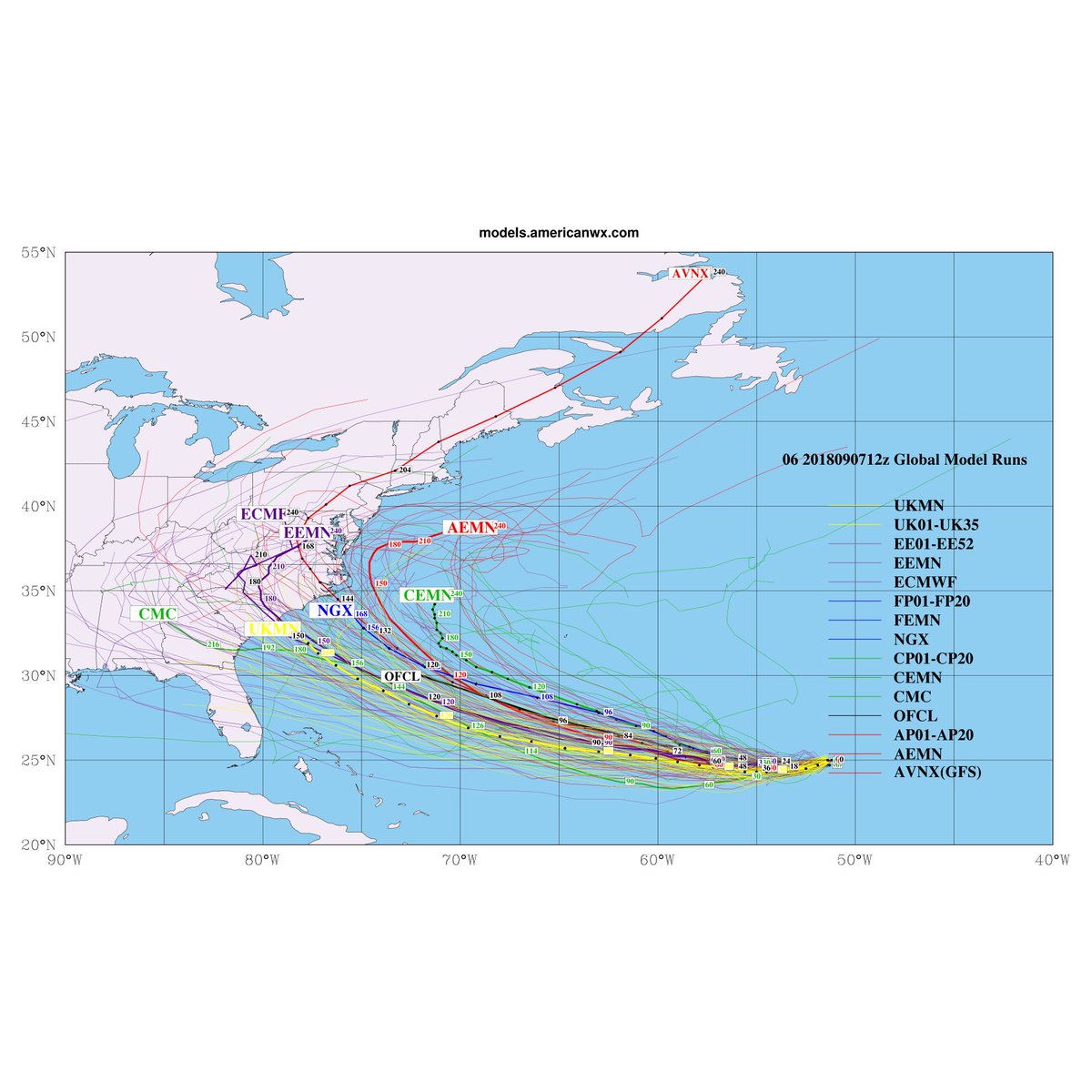
Looks like the GFS takes TD9 north out of the Caribbean in fantasy land time obviously plenty of time to track that one.

Posted on 9/7/18 at 8:07 pm to rds dc
What is your thoughts on #9?
Posted on 9/7/18 at 8:08 pm to rds dc
18z HWRF goes gang busters with Florence

Posted on 9/7/18 at 8:10 pm to rds dc


 Page 107 of 400

Popular
Back to top