- My Forums
- Tiger Rant
- LSU Recruiting
- SEC Rant
- Saints Talk
- Pelicans Talk
- More Sports Board
- Fantasy Sports
- Golf Board
- Soccer Board
- O-T Lounge
- Tech Board
- Home/Garden Board
- Outdoor Board
- Health/Fitness Board
- Movie/TV Board
- Book Board
- Music Board
- Political Talk
- Money Talk
- Fark Board
- Gaming Board
- Travel Board
- Food/Drink Board
- Ticket Exchange
- TD Help Board
Customize My Forums- View All Forums
- Show Left Links
- Topic Sort Options
- Trending Topics
- Recent Topics
- Active Topics
Started By
Message
re: Hurricane Dorian - Headed to Canada
Posted on 8/25/19 at 12:55 pm to rds dc
Posted on 8/25/19 at 12:55 pm to rds dc
Dorian is a small storm so it is even harder than normal to figure out what is going on. There won't be any recon into the storm until tomorrow and there haven't been in recent microwave passes, so it is hard to tell what is going on with this burst of convection.

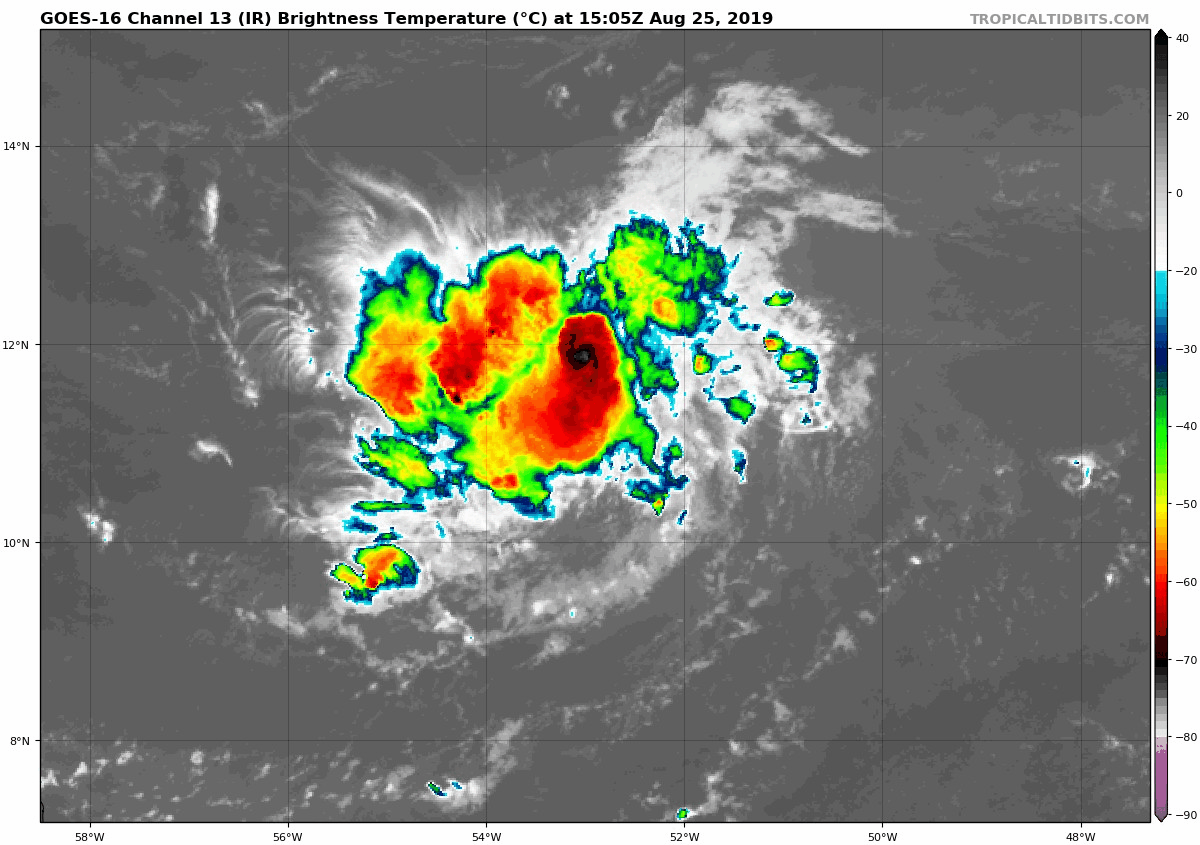
On the visible image there are signs of dry air surrounding the system with convection in the outer bands collapsing and spitting outflow boundaries. If that inner deep burst of convection is over the LLC then this could be the beginning of some significant strengthening. If it is tilted by shear or is ingesting dry air then it might collapse in the near future resulting in more of a steady state storm. This is what the models are showing for today, burst of disorganized convection and not much more strengthening for the system. It is just impossible to tell without being able to see under the clouds.
On the visible image there are signs of dry air surrounding the system with convection in the outer bands collapsing and spitting outflow boundaries. If that inner deep burst of convection is over the LLC then this could be the beginning of some significant strengthening. If it is tilted by shear or is ingesting dry air then it might collapse in the near future resulting in more of a steady state storm. This is what the models are showing for today, burst of disorganized convection and not much more strengthening for the system. It is just impossible to tell without being able to see under the clouds.
 2
2

Posted on 8/25/19 at 1:14 pm to rds dc
Looks like the latest Canadian model keeps it weak and west then develops it just south of Cuba in about a week. Then it moves into the Gulf and strengthens. It seems like the best chance of it eventually developing into a significant system would be if it stays weaker over the next 5 days or so.
Posted on 8/25/19 at 1:17 pm to NorthEndZone
I sure wouldn't sleep on her, them petite ones are another class of 'cane

Posted on 8/25/19 at 6:51 pm to wfallstiger
According to the HWRF, cancel your trips to Punta Cana.


Posted on 8/25/19 at 7:12 pm to GEAUXmedic
No need to ruffle feathers there. RD has this. 
Posted on 8/25/19 at 7:23 pm to NorthEndZone
anything that makes it into the gulf should be considered a big risk.
Posted on 8/25/19 at 7:23 pm to GEAUXmedic
quote:
According to the HWRF, cancel your trips to Punta Cana.
Might wash away all that fatally-toxic liquor.
This post was edited on 8/25/19 at 7:24 pm
Posted on 8/25/19 at 9:30 pm to GEAUXmedic
quote:
According to the HWRF, cancel your trips to Punta Cana.
That run shows what could happen if the system can get north of the mountains.

18z GEFS and 00z Early Cycle both have some tracks drifting north of the mountains.


Posted on 8/25/19 at 11:11 pm to rds dc
00z GFS appears to be following the 18z GEFS mean... Trapped under a ridge and heading westward towards S. FL.
Posted on 8/26/19 at 5:49 am to rds dc
quote:
That run shows what could happen if the system can get north of the mountains.
Reminds me of something like an Andrew type storm.
From a size perspective, Andrew was a small compact system but packed a major punch near the center, see Homestead 1992.
Posted on 8/26/19 at 5:50 am to rds dc
Dorian ain't going Grey

Posted on 8/26/19 at 6:19 am to Pectus
Can you picture it?
Posted on 8/26/19 at 6:35 am to rds dc
I just wanna k ow if I’m gonna get some days off work so i can chill, watch Netflix, and drink beer.
All while getting paid to do so
All while getting paid to do so
Posted on 8/26/19 at 6:40 am to rds dc
I feel like this storm is gonna be a headache to track. It could easily die or it could survive and affect potentially the Gulf if it can get north of Hispaniola.
Posted on 8/26/19 at 6:41 am to rds dc
This one has my full attention. These late August storms stress me out ever since Katrina.
Posted on 8/26/19 at 6:52 am to rds dc
Thanks for the updates.
Posted on 8/26/19 at 7:57 am to Mudminnow
quote:
Thanks for the updates.
Posted on 8/26/19 at 8:01 am to rds dc
Dorian strengthening some.
Euro is picking up on it now and has it hitting Florida/Georgia as a hurricane and it mostly missing Hispaniola allowing it to not dissipate completely.
This is the worst case scenario that was laid out on Tropical Tidbits where it misses the big islands and splits between the two upper level lows missing most of the shear
Posted on 8/26/19 at 8:53 am to deltaland
When would it be in the gulf if it goes that way?
Posted on 8/26/19 at 9:24 am to Janky
probably just in time to screw up our gator season in MS as usual. Past 2 years had systems come in and wipe out half the season might as well continue the trend
This post was edited on 8/26/19 at 9:26 am

 Page 5 of 263

Popular
Back to top