- My Forums
- Tiger Rant
- LSU Recruiting
- SEC Rant
- Saints Talk
- Pelicans Talk
- More Sports Board
- Fantasy Sports
- Golf Board
- Soccer Board
- O-T Lounge
- Tech Board
- Home/Garden Board
- Outdoor Board
- Health/Fitness Board
- Movie/TV Board
- Book Board
- Music Board
- Political Talk
- Money Talk
- Fark Board
- Gaming Board
- Travel Board
- Food/Drink Board
- Ticket Exchange
- TD Help Board
Customize My Forums- View All Forums
- Show Left Links
- Topic Sort Options
- Trending Topics
- Recent Topics
- Active Topics
Started By
Message
re: Helene - Recovery Begins...Devastating Flash Flooding in Western NC and Eastern TN
Posted on 9/24/24 at 4:47 pm to DVinBR
Posted on 9/24/24 at 4:47 pm to DVinBR
Dr. Levi Cowan
@TropicalTidbits
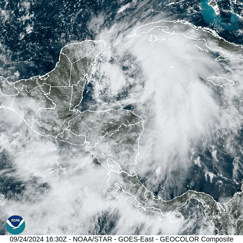
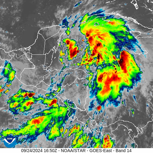
#Helene is steadily becoming better organized this afternoon as deep convective bands begin encircling the center in more symmetric fashion than previously. Buoy 42056 reveals a sharp pressure fall, with central pressure likely 993-994mb now. An inner core max wind band may not yet be well-developed, but will likely follow in the near-future. The timing of the inner core formation is tied to the timing of peak intensification rates.
These trends suggest that Helene is beginning to take advantage of an increasingly favorable environment as it approaches the Yucatan Channel, and risks to northern #Florida and southern #Georgia are growing. Hurricane Warnings have been issued, including inland portions of the Florida Panhandle. Hurricane Watches extend into inland Georgia. With a high-end storm surge and wind event expected, hopefully residents are taking this storm seriously.
 0
0

Posted on 9/24/24 at 4:48 pm to Thracken13
Loading Twitter/X Embed...
If tweet fails to load, click here. quote:
#Helene is steadily becoming better organized this afternoon as deep convective bands begin encircling the center in more symmetric fashion than previously. Buoy 42056 reveals a sharp pressure fall, with central pressure likely 993-994mb now. An inner core max wind band may not yet be well-developed, but will likely follow in the near-future. The timing of the inner core formation is tied to the timing of peak intensification rates.
These trends suggest that Helene is beginning to take advantage of an increasingly favorable environment as it approaches the Yucatan Channel, and risks to northern #Florida and southern #Georgia are growing. Hurricane Warnings have been issued, including inland portions of the Florida Panhandle. Hurricane Watches extend into inland Georgia. With a high-end storm surge and wind event expected, hopefully residents are taking this storm seriously.

Posted on 9/24/24 at 5:01 pm to LegendInMyMind
Posted on 9/24/24 at 5:06 pm to LegendInMyMind
Levi's killing me. Its moving too fast for appreciable strengthening on approach AND moving too fast for appreciable weakening at landfall. The tiebreaker is moving so fast this bitch won't hang for very long
Posted on 9/24/24 at 5:11 pm to UncleFestersLegs
So just to clarify, you know more about this than Levi does?
Posted on 9/24/24 at 5:13 pm to TheRouxGuru
Absolutely not. I believe every word he says and I just can't handle the truth
I will say that he's hinting cat3 at landfall which got me off my dining room table and un-noosed after the cat 5 posts earlier in the thread so I kinda thank him for that
I will say that he's hinting cat3 at landfall which got me off my dining room table and un-noosed after the cat 5 posts earlier in the thread so I kinda thank him for that
This post was edited on 9/24/24 at 5:24 pm
Posted on 9/24/24 at 5:37 pm to UncleFestersLegs
Meanwhile, we have a little prelude to the second season up North. There have been several tor warnings this evening. One looked to have been down for a bit in northern Indiana.
Posted on 9/24/24 at 5:52 pm to Bobby OG Johnson
Posted on 9/24/24 at 6:03 pm to LegendInMyMind
Unfortunately Helene is starting to cook this evening. Pressure down to 991mb and satellite appearance looking much better. It’s also wrapping up into that fist that often precedes strengthening.
Posted on 9/24/24 at 6:04 pm to slackster
Yep, starting to get the look.
Posted on 9/24/24 at 6:06 pm to LegendInMyMind
First drop in the eye had pressure at 991
Posted on 9/24/24 at 6:06 pm to slackster
18z HMON running now. 14mb stronger through 33 hours then the previous run
Posted on 9/24/24 at 6:06 pm to slackster
That rolled up fist look, or shrimp if ya prefer, is one of those classic looks of strengthening in this phase of the game.
Posted on 9/24/24 at 6:13 pm to Duke
I was listening to Levi earlier saying there was a decent chance it would shrug off that dry air just off the Yucatan. Does it look like that is happening?
Posted on 9/24/24 at 6:13 pm to Duke
Pretty cool to get a buoy and dropsonde at roughly the same time.
Loading Twitter/X Embed...
If tweet fails to load, click here.Posted on 9/24/24 at 6:14 pm to GEAUXT
quote:
I was listening to Levi earlier saying there was a decent chance it would shrug off that dry air just off the Yucatan. Does it look like that is happening?
Yep. What we're seeing now is not a storm struggling with dry air entrainment.

Posted on 9/24/24 at 6:18 pm to Jake88
quote:
No. The Graf had Francine passing west to east just south of New Orleans and onto the mississipi coast. NHC missed it by about 40 to the west of the actual path.
Generally agree on this point and as it got closer Fox started following the NHC forecast track.
What Bruce got correct from day 1 was Fran was headed towards the Nola area and not Lake Chuck as the NHC thought initially. He became quite vocal about it.
Look, it’s an imperfect science with high consequences, right or wrong. The wrong part gets more people killed and I don’t blame NHC for being cautious, as much as I’d prefer perfection.
The sum total of atmospheric observables ambiguity are simply too opaque to achieve precise accuracy at this time. Which can be very frustrating for us that live along the coast.
Posted on 9/24/24 at 6:22 pm to Mr Breeze
quote:
The sum total of atmospheric observables ambiguity are simply too opaque to achieve precise accuracy at this time. Which can be very frustrating for us that live along the coast.
We also live in a time where people track a couple hundred mile wide hurricane down to the street level, putting big stock in five mile shifts as if it has any real implication as to impacts.
Posted on 9/24/24 at 6:24 pm to LegendInMyMind
Well, that sucks

 Page 85 of 310

Popular
Back to top