




- My Forums
- Tiger Rant
- LSU Recruiting
- SEC Rant
- Saints Talk
- Pelicans Talk
- More Sports Board
- Fantasy Sports
- Golf Board
- Soccer Board
- O-T Lounge
- Tech Board
- Home/Garden Board
- Outdoor Board
- Health/Fitness Board
- Movie/TV Board
- Book Board
- Music Board
- Political Talk
- Money Talk
- Fark Board
- Gaming Board
- Travel Board
- Food/Drink Board
- Ticket Exchange
- TD Help Board
Customize My Forums- View All Forums
- Show Left Links
- Topic Sort Options
- Trending Topics
- Recent Topics
- Active Topics
Started By
Message
re: Heavy rain event setting up for the first part of next week
Posted on 5/21/17 at 6:06 am to EastBankTiger


Posted on 5/21/17 at 6:06 am to EastBankTiger
quote:
511 AM CDT Sun May 21 2017
This Hazardous Weather Outlook is for portions of Southeast
Louisiana...South Mississippi and the adjacent coastal waters.
.DAY ONE...Today and Tonight
Scattered to numerous showers and thunderstorms are possible
today. Thunderstorms will produce frequent lightning and brief
heavy downpours. A few storms could become strong to severe
with the main concern being strong to damaging winds and hail.
One or two quick short lived tornadoes can not be ruled out
however this threat is quite low.
.DAYS TWO THROUGH SEVEN...Monday through Saturday
Numerous to widespread showers and thunderstorms are expected
Monday through Tuesday as a weak front stalls across the area.
Heavy rain will be a major concern during this time with event
totals expected to range from 3 to 6 inches although this could be
a conservative estimate. Locally higher totals are expected and if
storms train over some areas multiple times it is not out of the
question to those locations could see in excess of 12 inches of
rain. A Flash Flood Watch has been issued for all of the area from
Monday morning through Tuesday. Depending on where the heaviest
rain sets up there could be river flooding issues as well.
After Tuesday no hazardous weather is anticipated.
.SPOTTER INFORMATION STATEMENT...
Please relay any reports of severe weather or flooding to local
law enforcement or the National Weather Service.
This post was edited on 5/21/17 at 6:07 am
 1
1

Posted on 5/21/17 at 6:07 am to GEAUXmedic
quote:
348 AM CDT Sun May 21 2017
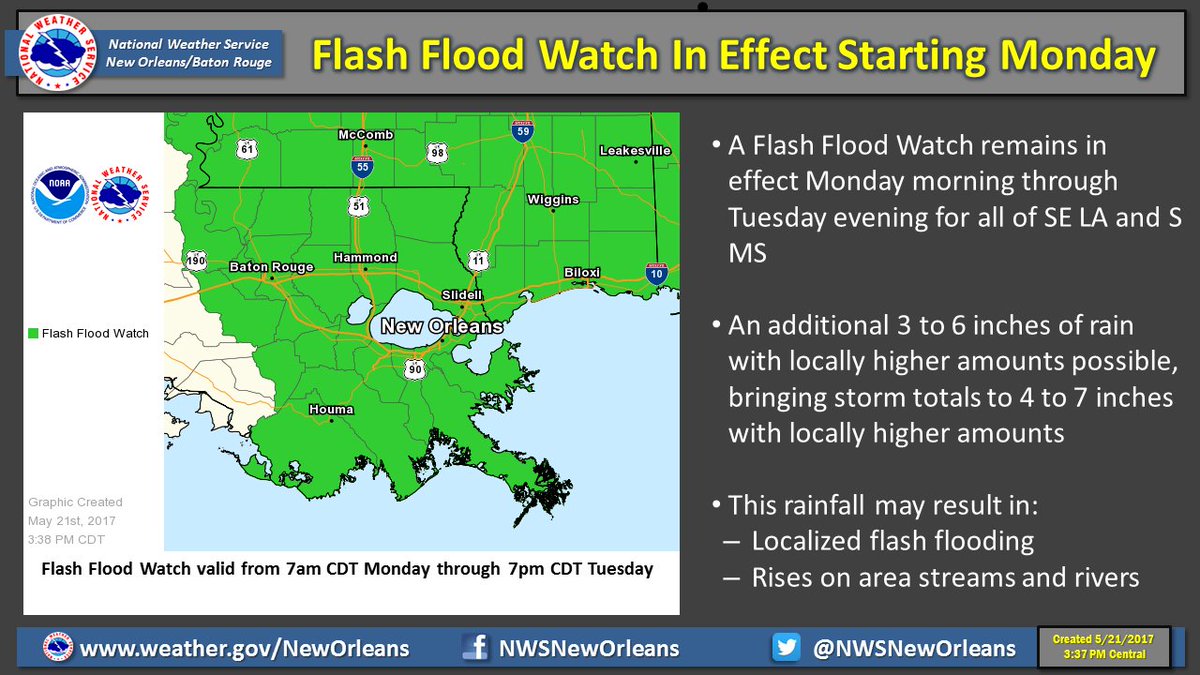
...FLASH FLOOD WATCH IN EFFECT FROM MONDAY MORNING THROUGH
TUESDAY EVENING...
The National Weather Service in New Orleans has issued a
* Flash Flood Watch FOR portions of southeast Louisiana and
Mississippi, including the following areas, in southeast
Louisiana, Ascension, Assumption, East Baton Rouge, East
Feliciana, Iberville, Livingston, Lower Jefferson, Lower
Lafourche, Lower Plaquemines, Lower St. Bernard, Lower
Terrebonne, Northern Tangipahoa, Orleans, Pointe Coupee,
Southern Tangipahoa, St. Charles, St. Helena, St. James, St.
John The Baptist, St. Tammany, Upper Jefferson, Upper
Lafourche, Upper Plaquemines, Upper St. Bernard, Upper
Terrebonne, Washington, West Baton Rouge, and West Feliciana.
In Mississippi, Amite, Hancock, Harrison, Jackson, Pearl
River, Pike, Walthall, and Wilkinson.
* from Monday morning through Tuesday evening
* A slow moving cold front will bring multiple rounds of heavy
rainfall over the watch area.
* Heavy rainfall from thunderstorms is expected to produce storm
total accumulations generally between 3 and 6 inches through
Tuesday evening. Some locally higher amounts could be possible.
PRECAUTIONARY/PREPAREDNESS ACTIONS...
A Flash Flood Watch means that conditions may develop that lead
to flash flooding. Flash flooding is a very dangerous situation.
You should monitor later forecasts and be prepared to take action
should Flash Flood Warnings be issued.
Posted on 5/21/17 at 7:48 am to GEAUXmedic
Posted on 5/21/17 at 1:44 pm to GEAUXmedic
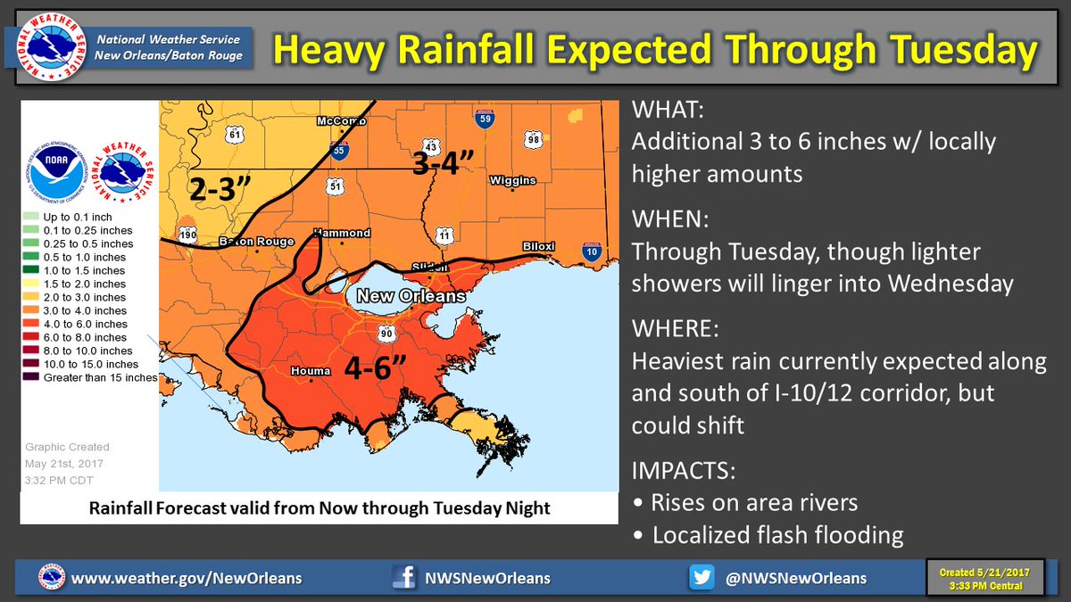
The rainfall will definitely be more than meteorologists were predicting just two days ago.
Posted on 5/21/17 at 4:00 pm to Jim Rockford
quote:
Stay dry.
Next week? Whatchu talking 'bout Willis? It's here now.
Posted on 5/21/17 at 5:05 pm to Jim Rockford
What about the Mississippi River? It can't afford to get to much higher. I took this picture yesterday at the softball game. The top of barges are over the levee.


Posted on 5/21/17 at 5:37 pm to OweO
quote:
What about the Mississippi River?
Areas East of the Mississippi River in Louisiana do not drain to the Mississippi. The river is driven largely by upstream events anyway and if there's any problem, they'll just open the spillways to the North to drain the river to the Atchafalaya Basin.
Posted on 5/21/17 at 5:37 pm to OweO
This rain won't affect the Mississippi much. It will affect the Amite Basin though.
Posted on 5/21/17 at 5:38 pm to TigerstuckinMS
quote:
Areas East of the Mississippi River in Louisiana do not drain to the Mississippi. The river is driven largely by upstream events anyway and if there's any problem, they'll just open the spillways to the North to drain the river to the Atchafalaya Basin.
I gotcha. And that rarely happens right? Opening up the spillways? It seems like its been awhile since I remember them doing it.


Posted on 5/21/17 at 5:40 pm to OweO
God damn it, Chris. Read a book.
Posted on 5/21/17 at 5:46 pm to The Boat

MESOSCALE PRECIPITATION DISCUSSION 0256...CORRECTED
NWS WEATHER PREDICTION CENTER COLLEGE PARK MD
636 PM EDT SUN MAY 21 2017
CORRECTED FOR A COUPLE OF TYPOS
AREAS AFFECTED...SOUTHEAST LA
CONCERNING...HEAVY RAINFALL...FLASH FLOODING POSSIBLE
VALID 212230Z - 220130Z
SUMMARY...THUNDERSTORMS CONTINUE TO MASS ACROSS SOUTHEAST LA AHEAD
OF A MESOSCALE WAVE. HOURLY RAIN RATES UP TO 2.5", WITH LOCAL
AMOUNTS TO 4", REMAIN POSSIBLE OVER THE NEXT FEW HOURS.
DISCUSSION...THE TAIL END OF A FORWARD PROPAGATING CONVECTIVE LINE
IS DROPPING SLOWLY INTO SOUTH-CENTRAL LA AT THIS TIME, AS A
MESOSCALE WAVE NEAR NEW IBERIA IS HOLDING UP FORWARD PROGRESSION.
THIS REGION IS UNDER THE BASE OF A SHORTWAVE MOVING ACROSS
SOUTHEAST AR AT THIS TIME. RADAR ESTIMATES CONTINUE TO INDICATE
2.5" AN HOUR RAIN RATES WHERE CELLS MERGE AND SHORT PERIODS OF
TRAINING OCCUR. MOTION OF THE ACTIVITY HAS BEEN CHAOTIC, AS
THUNDERSTORMS HAVE BEEN MOVING INTO THE REGION FROM THE SOUTH NEAR
ST. MARY PARISH, BUT THE GROUPING HAS BEEN MOVING SOUTHEAST AT 15
KTS. THIS IS DOUBLING THE STORM BASE INFLOW, AS 850 HPA WINDS ARE
FROM THE EAST-SOUTHEAST AT 15 KTS. PRECIPITABLE WATER VALUES
REMAIN NEAR 2" AND THE MUCAPE GRADIENT IS ALIGNED
NORTHWEST-SOUTHEAST, HELPING TO EXPLAIN CELL MOTION. LOW-LEVEL
INFLOW IS FROM THE SOUTHEAST, NOT FROM THE MAIN INSTABILITY POOL
NEAR MARSH ISLAND, IMPORTING MUCAPES OF 1000-3000 J/KG INTO THE
CLUSTER. EFFECTIVE BULK SHEAR IS AROUND 40 KTS.
THE EXPECTATION IS FOR THE CONVECTIVE PROFILE ALONG THE DIRECTION
OF MOTION TO EVENTUALLY NARROW WITH TIME AS THE MESOSCALE WAVE
SHIFTS SOUTHEAST INTO THE GULF OF MEXICO, WHICH SHOULD CAUSE THE
HEAVY RAIN THREAT TO WANE OVER THE NEXT FEW HOURS. AS THE
ARKANSAS SHORTWAVE MOVES FARTHER AFIELD, DIVERGENCE ALOFT SHOULD
SOMEWHAT LESSEN WITH TIME. UNTIL THEN, HOURLY RAIN RATES UP TO
2.5" REMAIN POSSIBLE. THE MESOSCALE GUIDANCE GENERALLY INDICATES
LOCAL AMOUNTS TO 4" DURING THE NEXT SEVERAL HOURS, WHICH SEEMS
REASONABLE.
ROTH


Posted on 5/21/17 at 7:42 pm to The Boat
quote:
God damn it, Chris. Read a book.

Posted on 5/21/17 at 9:22 pm to Martini
Flash flood watch extended westward

Posted on 5/21/17 at 9:28 pm to rds dc
Here comes another L to just park its tail and crap
Posted on 5/21/17 at 10:05 pm to lucaslsu
The latest GFS really backed off on rain totals. Going from around 5 inches to less than 2. I heard the GFS has really done horribly lately, even in the 5 day range, though.
Any other models starting to sniff out that it may not be so bad or is the GFS out to lunch?
Any other models starting to sniff out that it may not be so bad or is the GFS out to lunch?
Posted on 5/21/17 at 10:08 pm to BigB0882
quote:
The latest GFS really backed off on rain totals. Going from around 5 inches to less than 2. I heard the GFS has really done horribly lately, even in the 5 day range, though.
Any other models starting to sniff out that it may not be so bad or is the GFS out to lunch?
The GFS has been a clown show here lately. The 12z Euro and Euro EPS are both pretty wet from Houston to New Orleans.
Posted on 5/22/17 at 7:54 am to rds dc
Areas south of the lake could pick up another 7"


Posted on 5/22/17 at 7:58 am to Jim Rockford
I hope the roads become an issue so I can go home.

 Page 2 of 3

Popular
Back to top
 Follow TigerDroppings for LSU Football News