




 0
0








- My Forums
- Tiger Rant
- LSU Recruiting
- SEC Rant
- Saints Talk
- Pelicans Talk
- More Sports Board
- Fantasy Sports
- Golf Board
- Soccer Board
- O-T Lounge
- Tech Board
- Home/Garden Board
- Outdoor Board
- Health/Fitness Board
- Movie/TV Board
- Book Board
- Music Board
- Political Talk
- Money Talk
- Fark Board
- Gaming Board
- Travel Board
- Food/Drink Board
- Ticket Exchange
- TD Help Board
Customize My Forums- View All Forums
- Show Left Links
- Topic Sort Options
- Trending Topics
- Recent Topics
- Active Topics
Started By
Message
re: Harvey ***Catastrophic Flooding Event***
Posted on 8/27/17 at 11:17 pm to redstick13
Posted on 8/27/17 at 11:17 pm to redstick13
quote:
There it is again. Confirmed 10 feet of water released into Bay City. Fire and police pulling out the city and mandatory evac.
Holy shite. I stayed there during a long turnaround a few years back and it was bone Dry. Pretty much scrubland. Absolutely insane to think that there's 10 feet coming their way
Posted on 8/27/17 at 11:18 pm to cwill
quote:
Is the Brazos expected to top the banks/levees there?
Some areas of Greatwood are under voluntary evacuation. The Brazos may top some portions of the levee at Greatwood.
Posted on 8/27/17 at 11:18 pm to cwill
quote:
I think the news did a poor job explaining it is one reason people are asking questions.
No doubt about it. They came in wanting to discuss Buffalo Bayou, and the emergency management guy was talking only about the flooding from the rising reservoir itself, not the release.
It has been a clusterfrick every since.
Posted on 8/27/17 at 11:19 pm to cwill
quote:
Have a friend in Greatwood just south of the Brazos River. I can't find reliable info on the situation there. Is the Brazos expected to top the banks/levees there?
They have mandatory evacuations now for the Richmond /Rosenberg areas and voluntary toward Siena Plantation area.
Posted on 8/27/17 at 11:19 pm to cwill
Fort Bend just issued a bunch of new mandatory evacuations. I'm trying to find a list of the utility districts that were ordered to evacuate.
They had a press conference and said to look online for the map...the only map on their site is outdated. Fort Bend needs to get thier shite together.
They had a press conference and said to look online for the map...the only map on their site is outdated. Fort Bend needs to get thier shite together.
This post was edited on 8/27/17 at 11:20 pm
Posted on 8/27/17 at 11:20 pm to cwill
quote:
I think the news did a poor job explaining it is one reason people are asking questions.
Agreed as did the guy from HCFDC. They kept saying it's still going to flood people on the back side of these reservoirs.
Had they said it is to help protect downtown and people along buffalo bayou while also giving those around the reservoirs a little more time from what is imminent, then more
People would've understood it.
Posted on 8/27/17 at 11:20 pm to redstick13
quote:
Unfortunately there are a lot needing help right now.
Last year during BTR flooding taking a rest halt wasnt an option for my crew of 20 LMTV. The LANG pushed us out for 3 days straight doing high water rescue from the time the flooding started.
This post was edited on 8/27/17 at 11:21 pm
Posted on 8/27/17 at 11:20 pm to The Bruce
quote:
The neighborhoods on the west end reservoir releases in Cinco Ranch area will get feet of water in their houses for months.
That's incorrect. The neighborhoods on the wed end reservoir in Cinco Ranch will get water for months with or without the releases. The release only helps the neighborhoods on the west side.
Posted on 8/27/17 at 11:21 pm to FulshearTiger
Near Tompkins high falcon landing between spring green and gaston
Posted on 8/27/17 at 11:22 pm to tketaco
 thank you for the edit. I tried reading that five times and kept struggling.
 Posted on 8/27/17 at 11:22 pm to TheChosenOne
quote:
They had a press conference and said to look online for the map...the only map on their site is outdated. Fort Bend needs to get thier shite together.
They said the maps were coming. Didn't sound like they were available yet. The presser was done as soon as they had made a decision.
Posted on 8/27/17 at 11:22 pm to The Bruce
Friend lives just NW of midtown. How will these releases affect them?
Posted on 8/27/17 at 11:22 pm to Large Farva
quote:
thank you for the edit. I tried reading that five times and kept struggling.
My goddman fat thumbs and Modellos.
Posted on 8/27/17 at 11:23 pm to slackster
Posted on 8/27/17 at 11:23 pm to slackster
quote:
That's incorrect. The neighborhoods on the wed end reservoir in Cinco Ranch will get water for months with or without the releases. The release only helps the neighborhoods on the west side.
That is the issue. Too many don't realize this isnt causing he flooding to those areas. That was going to happen anyway. In fact this is delaying those floods by a few hours, thus buying those people some time.
Posted on 8/27/17 at 11:24 pm to rds dc
FYI
There is a corndog off the coast of Africa.

There is a corndog off the coast of Africa.
Posted on 8/27/17 at 11:24 pm to Geauxgurt
Harvey grew a big dick on the radar
Posted on 8/27/17 at 11:25 pm to The Bruce
This is why Bay City is fricked...
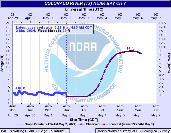
Water projected to get to 52.5 feet, but levees in Bay City only go to 44 feet.
Water projected to get to 52.5 feet, but levees in Bay City only go to 44 feet.
quote:
44 levees on the Bay City side of river are overtopped.
Posted on 8/27/17 at 11:25 pm to droman225
Posted on 8/27/17 at 11:26 pm to TrueTiger
quote:
There is a corndog off the coast of Africa.
That summbitch need to take a quick curve to the right and the first land it needs to touch is Greenland as an extra-tropical depression.

 Page 455 of 618


Popular
Back to top
 Follow TigerDroppings for LSU Football News