- My Forums
- Tiger Rant
- LSU Recruiting
- SEC Rant
- Saints Talk
- Pelicans Talk
- More Sports Board
- Fantasy Sports
- Golf Board
- Soccer Board
- O-T Lounge
- Tech Board
- Home/Garden Board
- Outdoor Board
- Health/Fitness Board
- Movie/TV Board
- Book Board
- Music Board
- Political Talk
- Money Talk
- Fark Board
- Gaming Board
- Travel Board
- Food/Drink Board
- Ticket Exchange
- TD Help Board
Customize My Forums- View All Forums
- Show Left Links
- Topic Sort Options
- Trending Topics
- Recent Topics
- Active Topics
Started By
Message
 1
1


Posted on 8/22/17 at 4:05 pm to rds dc
With the heavy convection starting to explode as this reemerges over 85 degree water, I wouldnt be surprised to see a hurricane by midday tomorrow.
Posted on 8/22/17 at 4:06 pm to rds dc
New QPF forecast ramping up the totals...

Posted on 8/22/17 at 4:08 pm to NorthEndZone
Not good

Posted on 8/22/17 at 4:08 pm to OchoDedos
Agreed.....

Posted on 8/22/17 at 4:09 pm to OchoDedos
I wouldn't be shocked to see a CAT-2 by tomorrow night. The other storm that came off the Yucatan earlier this month had a strong hurricane form within hours.

Posted on 8/22/17 at 4:09 pm to slackster
quote:
This was the forecast from 8/12/16.
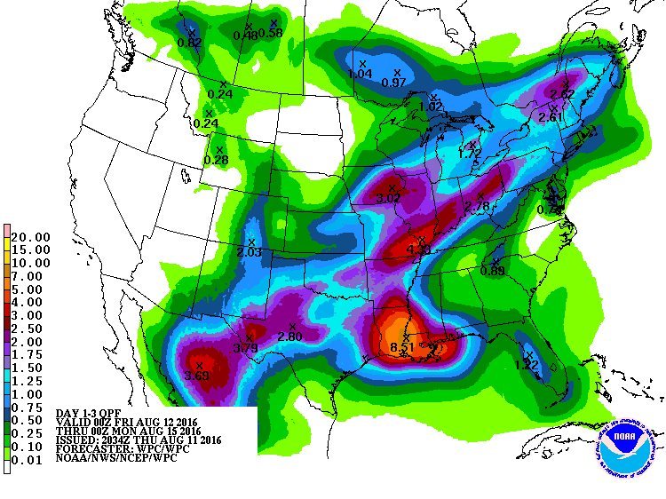
And this was the forecast from 8/11/16.
I will stick by what I said earlier. BR won't get near 10-15 inches of rain, unless this system moves in a more northerly direction. I just don't see anything pulling it north.
This post was edited on 8/22/17 at 4:11 pm
Posted on 8/22/17 at 4:09 pm to slackster
Posted on 8/22/17 at 4:10 pm to TigerstuckinMS
That's right.... it got more......
Posted on 8/22/17 at 4:17 pm to TigerstuckinMS
Ok. We get it. He doesn't know what he's talking about. That has been previously established in this thread.
This post was edited on 8/22/17 at 4:20 pm
Posted on 8/22/17 at 4:19 pm to NorthEndZone
7 or 8 inches of rain between now and Tuesday, fine. 20+ inches? No thank you. If this motherfricker stalls over the southern half of the state, it may be returned to the sea permanently.
Posted on 8/22/17 at 4:20 pm to Muice
quote:
How reliable are the NAM models?
I believe they're more for short-range forecast, but I'm not sure.
The current 18z run has this thing stalling out in the GOM south of Galveston and east of Brownsville @ 84 hours out. The Euro and GFS have it over land by that time.
Posted on 8/22/17 at 4:22 pm to OchoDedos
quote:
With the heavy convection starting to explode as this reemerges over 85 degree water, I wouldnt be surprised to see a hurricane by midday tomorrow.
There is still shear from the ULL to deal with and the developing LLC is still embedded within the wave axis, so development should be pretty slow over the next 24 hours.
Posted on 8/22/17 at 4:25 pm to rds dc
If you're worried about flooding, you want a stronger storm, correct? Stronger storms wrap the rainfall tighter and move quicker. Yes or no?
Posted on 8/22/17 at 4:58 pm to dukke v
Didnt you say in this thread that there was no way this hits Texas?

Posted on 8/22/17 at 5:22 pm to ell_13
quote:
Anyone know what the forecasts were last year for the flood?
Here's the August 2016 400+ page Flood Thread
Looks like it was started the week before things got bad. Should establish a good timeline. Too bad the image hosting sites revoked message board privileges since then. No much in the way of visuals left.
Hope this helps.
Posted on 8/22/17 at 5:27 pm to rds dc
18z GFS is weaker again and heaviest rain totals are confined to coastal areas. Very tight gradient around Houston with 10-12" for the city but 40" down towards Galveston. Second landfall around Pecan Island, LA.
Posted on 8/22/17 at 5:28 pm to yurintroubl
I was supposed to fly out to Jacksonville that Friday, the 12th and had to cancel. I'm supposed to fly out to Jacksonville this Friday- hope its not a trend.
Posted on 8/22/17 at 5:29 pm to rds dc
looks like its stronger when it makes it 2nd landfall in Louisiana.
Posted on 8/22/17 at 5:30 pm to lsuman25
Pass over or very near to BR on the 30th.

 Page 23 of 618

Popular
Back to top