- My Forums
- Tiger Rant
- LSU Recruiting
- SEC Rant
- Saints Talk
- Pelicans Talk
- More Sports Board
- Fantasy Sports
- Golf Board
- Soccer Board
- O-T Lounge
- Tech Board
- Home/Garden Board
- Outdoor Board
- Health/Fitness Board
- Movie/TV Board
- Book Board
- Music Board
- Political Talk
- Money Talk
- Fark Board
- Gaming Board
- Travel Board
- Food/Drink Board
- Ticket Exchange
- TD Help Board
Customize My Forums- View All Forums
- Show Left Links
- Topic Sort Options
- Trending Topics
- Recent Topics
- Active Topics
Started By
Message
re: Harvey ***Catastrophic Flooding Event***
Posted on 8/25/17 at 9:58 am to Jim Rockford

Posted on 8/25/17 at 9:58 am to Jim Rockford
quote:
This looks a little better for Louisiana but what do I know.

I don't know, with the center sliding up East TX like that it would dump rain on West LA like Lake Charles/DeQuincy/ DeRidder/Leesville.
From what I gather it's a wait and see game. We know Corpus and surrounding areas are going to get smashed. Where exactly it tracks North will determine who the NE bands sit on.
 1
1

Posted on 8/25/17 at 9:58 am to CptBengal
Uh, that model was only out 84 hours.
Posted on 8/25/17 at 9:59 am to Duke
Dude on TWC just said they will not be surprised to see this stay as a hurricane for 36-42 hours after initial landfall.......

Posted on 8/25/17 at 9:59 am to IT_Dawg
Jesus christ. That's terrible
Posted on 8/25/17 at 10:00 am to rt3
quote:
Min pressure: 947 mb

Posted on 8/25/17 at 10:01 am to Clyde Tipton
I'm thinking when he said ok for Louisiana, he meant more southeast. Southwest will get some rain, but NO and BR should be fine.
Posted on 8/25/17 at 10:01 am to The Egg
10 AM is out

Posted on 8/25/17 at 10:01 am to baytiger
quote:
Intensification seems to have slowed if not stopped and the pressure isn't quite low enough to sustain cat 4 winds. I think we can count on a cat 3 at landfall but a low end cat 4 is still very possible.
Yea, the inner EW just won't give up. That appears to be preventing a complete ERC as the core fights with some lingering dry air.
Posted on 8/25/17 at 10:02 am to IT_Dawg
quote:
Dude on TWC just said they will not be surprised to see this stay as a hurricane for 36-42 hours after initial landfall.......
Brown Ocean Effect?
Posted on 8/25/17 at 10:02 am to Duke
quote:
It did move more north based on the last recon fix I saw.
Erractic movement is expected. It's like a massive top spinning away out there. Itll wobble north, it'll wobble west but generally keep it's heading.
For reference, from the recon fix 5.5 hours ago to the most recent fix, Harvey has moved 92km @ a bearing of 327 degrees. In layman terms, it has moved 10.5 MPH north by northwest over the last 5.5 hours.
Posted on 8/25/17 at 10:02 am to Duke
Bingo. The NAM model may not show huge rain totals for Louisiana but it only goes out to 84 hours. Most models show this impacting Louisiana, if it does at all, after that time period. Our rainfall totals would be more accurate at a reading around 120-144 hours from now.
Posted on 8/25/17 at 10:03 am to OldSouth
they just can't decide if they think it'll make it off land or not
Posted on 8/25/17 at 10:03 am to Duke
quote:
Uh, that model was only out 84 hours.
well, frick.
Posted on 8/25/17 at 10:03 am to OldSouth
Looks like as of now, Tuesday morning will decide if it intensifies before turning north.

Posted on 8/25/17 at 10:05 am to OldSouth
lurching to the east
Posted on 8/25/17 at 10:05 am to rds dc
quote:
Intensity forecasts become complicated once a hurricane develops
concentric eyewalls, and fluctuations in intensity become more
likely. If an eyewall replacement occurs, then Harvey's intensity
could decrease a bit while at the same time the overall wind field
increases in size. However, the hurricane remains in an environment
for intensification, and strengthening beyond the current intensity
is still possible before the center reaches land. But in the end,
the hurricane's exact intensity at landfall does not change the
fact that catastrophic flooding due to a prolonged period of heavy
rainfall and/or storm surge is expected at the coast and well inland
across much of southern and southeastern Texas. Slow weakening is
expected after Harvey crosses the coast since the center is not
expected to move very far inland, and the cyclone is likely to
maintain tropical storm status through Wednesday.
Harvey has not quite begun to slow down, and the initial motion
estimate is 315/9 kt. Strong mid-level ridging building over the
western United States is still expected to impede Harvey's forward
motion in the coming days, and the track guidance continues to show
the hurricane meandering or stalling near or just inland of the
Texas coast in 36-48 hours. Harvey could begin moving slowly
eastward on days 4 and 5 due to the influence of a mid-level
shortwave trough digging southward over the upper Midwest, but at
this time it is too early to say whether the center will definitely
re-emerge over the northwestern Gulf of Mexico.
quote:
2. A Storm Surge Warning is in effect for much of the Texas coast.
Life-threatening storm surge flooding could reach heights of 6 to 12
feet above ground level at the coast between the north entrance of
the Padre Island National Seashore and Sargent. For a depiction of
areas at risk, see the Storm Surge Watch/Warning Graphic at
hurricanes.gov. Due to the slow motion of Harvey and a prolonged
period of onshore flow, water levels will remain elevated for
several days.
3. Catastrophic and life-threatening flooding is expected across the
middle and upper Texas coast from heavy rainfall of 15 to 25 inches,
with isolated amounts as high as 35 inches, through Wednesday.
Please refer to products from your local National Weather Service
office and the NOAA Weather Prediction Center for more information
on the flooding hazard.
Posted on 8/25/17 at 10:05 am to The Egg
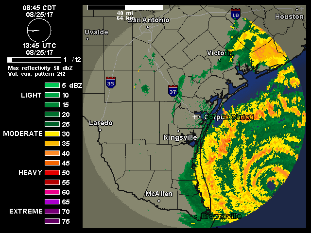
Looking at the radar, the new eyewall has completely closed off... end of EWRC?
Posted on 8/25/17 at 10:05 am to OldSouth
looks like they have it going a little further inland now.
Posted on 8/25/17 at 10:05 am to rt3
quote:
Brown Ocean Effect?
Never heard of that. Interesting stuff, thanks for the link.

Posted on 8/25/17 at 10:05 am to CptBengal
Earthquake in Dallas?

 Page 182 of 618

Popular
Back to top