- My Forums
- Tiger Rant
- LSU Recruiting
- SEC Rant
- Saints Talk
- Pelicans Talk
- More Sports Board
- Coaching Changes
- Fantasy Sports
- Golf Board
- Soccer Board
- O-T Lounge
- Tech Board
- Home/Garden Board
- Outdoor Board
- Health/Fitness Board
- Movie/TV Board
- Book Board
- Music Board
- Political Talk
- Money Talk
- Fark Board
- Gaming Board
- Travel Board
- Food/Drink Board
- Ticket Exchange
- TD Help Board
Customize My Forums- View All Forums
- Show Left Links
- Topic Sort Options
- Trending Topics
- Recent Topics
- Active Topics
Started By
Message
re: Friday weather thread. Tornado watches everywhere, warnings, too
Posted on 3/31/23 at 4:34 pm to tigerbandpiccolo
Posted on 3/31/23 at 4:34 pm to tigerbandpiccolo
Yeah Trio’s is gone. Videos from KATV look horrible
 3
3

Posted on 3/31/23 at 4:36 pm to GeorgeReymond
About to be another confirmed between Vinton and La Porte City, Iowa.

Posted on 3/31/23 at 4:37 pm to GeorgeReymond
Giant Tornado in Iowa...
SAF
R A W S A L E R T S
@rawsalerts
·
56m
??#BREAKING: A Confirmed large and extremely violent tornado is on the ground
??#Sigourney | #Iowa

SAF
R A W S A L E R T S
@rawsalerts
·
56m
??#BREAKING: A Confirmed large and extremely violent tornado is on the ground
??#Sigourney | #Iowa
This post was edited on 3/31/23 at 5:12 pm

Posted on 3/31/23 at 4:37 pm to JCinBAMA
Holy frick

Posted on 3/31/23 at 4:40 pm to GeorgeReymond
quote:
R A W S A L E R T S
@rawsalerts
·
25m
#BREAKING: A Confirmed large and extremely violent tornado is on the ground
#Sigourney | #Iowa
Posted on 3/31/23 at 4:40 pm to LegendInMyMind
quote:
I don't think it is, certainly not all of it. That CC drop away from the TDS started before the tornado had time to cycle that much debris
Gotya
Posted on 3/31/23 at 4:40 pm to Pedro
that one in Iowa is movign towards a client I have in Manchester, IA - they are going to their basement and getting folks into the bank vault for safety
Posted on 3/31/23 at 4:41 pm to Wishnitwas1998
Posted on 3/31/23 at 4:42 pm to Bobby OG Johnson
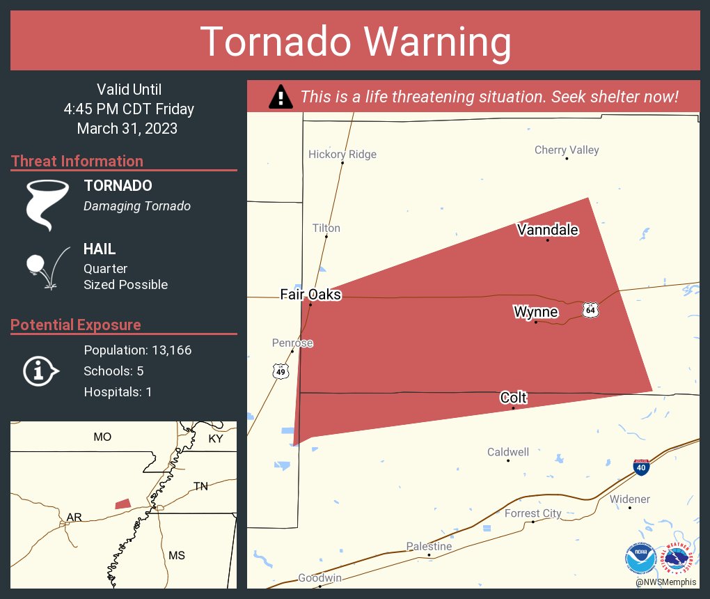
PDS now on tornado west of Memphis
Should go north to Memphis proper
Should
Should go north to Memphis proper
Should
Posted on 3/31/23 at 4:42 pm to Wishnitwas1998
quote:
PDS now on tornado west of Memphis
Should go north to Memphis proper
Should
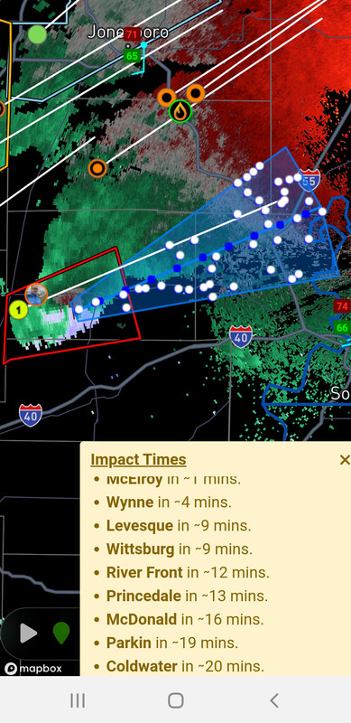
I'll try to keep posting the cone/track.
Posted on 3/31/23 at 4:44 pm to LegendInMyMind

Posted on 3/31/23 at 4:44 pm to Wishnitwas1998
Iowa City tornado may stay just west of the heart of the city.
Posted on 3/31/23 at 4:45 pm to TigerGrl73
I know! Glad you got to go before today..
I saw a video someone took from the WLR target parking lot, by y’all. That came REAL close to y’all.
I saw a video someone took from the WLR target parking lot, by y’all. That came REAL close to y’all.
Posted on 3/31/23 at 4:45 pm to LegendInMyMind
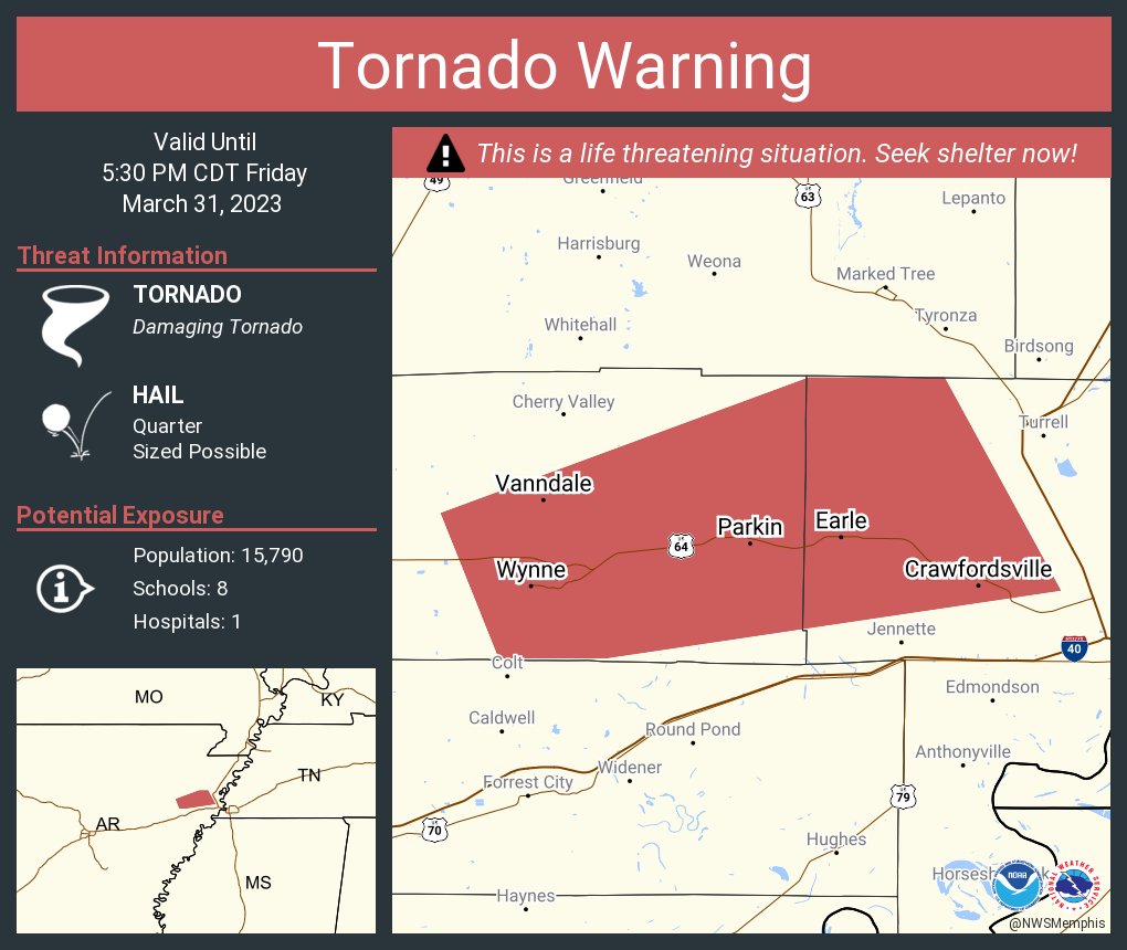
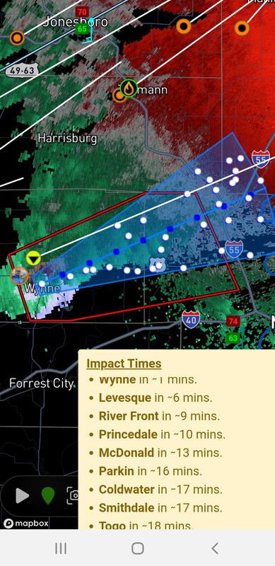
The thing about that Wynne storm is that it is by itself and will be for a while. It also has a very favorable environment ahead of it.
Posted on 3/31/23 at 4:45 pm to Thracken13
Looks to be going into Iowa City in a few minutes. Not good.
quote:
At 439 PM CDT, a confirmed tornado was located over Frytown, or 11 miles southwest of Iowa City, moving northeast at 45 mph.
HAZARD...Damaging tornado and baseball size hail.
SOURCE...Weather spotters confirmed tornado.
IMPACT...Flying debris will be dangerous to those caught without shelter. Mobile homes will be damaged or destroyed. Damage to roofs, windows, and vehicles will occur. Tree damage is likely.
This tornado will be near... University Heights, University Of Iowa and F.W. Kent Park around 450 PM CDT. Iowa City, Coralville, North Liberty, Tiffin, Oakdale, Coralville Lake Dam Complex and West Overlook around 455 PM CDT.
Posted on 3/31/23 at 4:49 pm to Bobby OG Johnson
OT
Sidenote if I go to jail for memes y'all make a givesendgo for me please & thanks
quote:
US Attorney EDNY
@EDNYnews
The verdict is in: Douglass Mackey has been found guilty.
Sidenote if I go to jail for memes y'all make a givesendgo for me please & thanks
Posted on 3/31/23 at 4:50 pm to NorthEndZone
quote:
At 443 PM CDT, a confirmed tornado was located near Windham, or 10
miles west of Iowa City, moving north at 30 mph.
HAZARD...Damaging tornado and baseball size hail.
SOURCE...Weather spotters confirmed tornado.
IMPACT...Flying debris will be dangerous to those caught without
shelter. Mobile homes will be damaged or destroyed. Damage
to roofs, windows, and vehicles will occur. Tree damage is
likely.
This tornado will be near...
Cosgrove around 450 PM CDT.
University Heights around 455 PM CDT.
Other locations in the path of this tornadic thunderstorm include
Oxford, Oakdale, F.W. Kent Park, Coralville, Tiffin, North Liberty,
Coralville Lake Dam Complex and West Overlook.
Posted on 3/31/23 at 4:51 pm to NorthEndZone
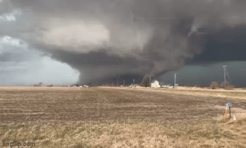
That tornado ramped up leaving Wynne. I believe it was on the ground in Wynne.

 Page 23 of 48

Back to top