- My Forums
- Tiger Rant
- LSU Recruiting
- SEC Rant
- Saints Talk
- Pelicans Talk
- More Sports Board
- Fantasy Sports
- Golf Board
- Soccer Board
- O-T Lounge
- Tech Board
- Home/Garden Board
- Outdoor Board
- Health/Fitness Board
- Movie/TV Board
- Book Board
- Music Board
- Political Talk
- Money Talk
- Fark Board
- Gaming Board
- Travel Board
- Food/Drink Board
- Ticket Exchange
- TD Help Board
Customize My Forums- View All Forums
- Show Left Links
- Topic Sort Options
- Trending Topics
- Recent Topics
- Active Topics
Started By
Message
 1
1

Posted on 9/11/24 at 3:14 pm to slackster
quote:
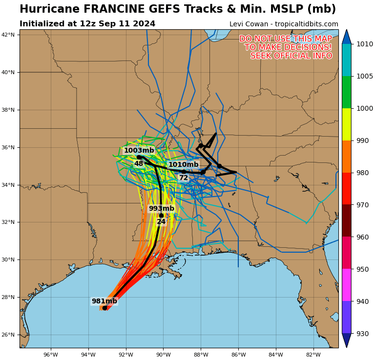
It's going east of NHC track but still a long way before it goes over New Orleans.
The center has fluctuated all over the cone throughout the day. Big arse eye......big arse wobbles.
Posted on 9/11/24 at 3:14 pm to TDsngumbo
quote:
The NHC just issued a brand new forecast path and, are y'all ready for this? It has the eye moving DUE NORTH then WEST of Ascension Parish and into Baton Rouge.
NHC hasn't updated forecast path since 10am
Posted on 9/11/24 at 3:15 pm to Tiger985
quote:But that "eye" is what 60-70 miles wide?
More like NNW. It's already beyond Morgan City and 50 miles from the coast.

Posted on 9/11/24 at 3:15 pm to slackster
So what is the news talking about then

Posted on 9/11/24 at 3:15 pm to TDsngumbo
quote:
The NHC just issued a brand new forecast path and, are y'all ready for this? It has the eye moving DUE NORTH then WEST of Ascension Parish and into Baton Rouge.
NHC hasn't put out a new path since 10 am, but they've updated the location every hour which makes their 10 am cone look like that. New cone comes out at 4 pm.

Posted on 9/11/24 at 3:15 pm to tigafan4life
He just had the graphic on live tv. It is true.

Posted on 9/11/24 at 3:15 pm to NorthEndZone
quote:
winds in Cut Off are not 60 mph. Maybe 35
Maybe the are measuring wind speed with the police depts radar gun.
Posted on 9/11/24 at 3:16 pm to PTLSU
quote:
Sustained wind forecast dropped to 40-45mph in Nola per WWL TV just now. Gusts 50-55. That’s still enough for possible outages but no longer 65-75 forecasted.
Everyone has to learn in their own special way that wind forecasting is mostly guesswork.

Posted on 9/11/24 at 3:16 pm to BRgetthenet
quote:
quote:
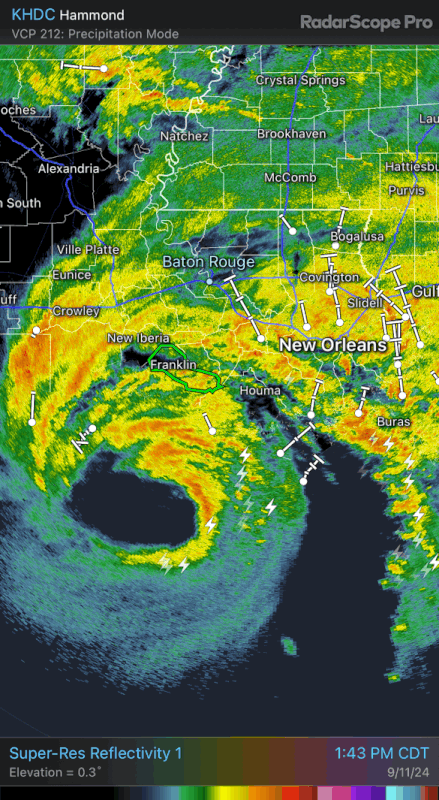
The northern eyewall just got to land. This thing is way ahead of schedule. Love it
On time and under budget.
How can it be a Louisiana storm then since everything here is always the opposite?
Posted on 9/11/24 at 3:16 pm to slackster
Then Josh Eachus needs to be told to apologize and correct his graphics.
Edit: the weather channel now has it on their radar when you put the tropical overlay on.
Edit: the weather channel now has it on their radar when you put the tropical overlay on.
This post was edited on 9/11/24 at 3:17 pm
Posted on 9/11/24 at 3:16 pm to Roll Tide Ravens
So gonna be closer to this?
Posted on 9/11/24 at 3:16 pm to Proximo
I'm seeing (watching Fox 8) that it is now steering pretty directly NORTH
I am sober and haven't ingested any alcohol
But that's what I'm taking away from this
I am sober and haven't ingested any alcohol
But that's what I'm taking away from this
Posted on 9/11/24 at 3:16 pm to TDsngumbo
quote:
He just had the graphic on live tv. It is true.
It's an updated location that is then mapped to the 10a forecast.
Posted on 9/11/24 at 3:16 pm to LSUFanHouston
Unless it turns north, it is definitely pointed right at Houma based on its recent tracking
Posted on 9/11/24 at 3:16 pm to TDsngumbo
Dang---what channel is he on? I had WAFB on....
Posted on 9/11/24 at 3:16 pm to LegendInMyMind
Cheer for Bruce. hip-hip hooray!
Posted on 9/11/24 at 3:17 pm to LegendInMyMind

Posted on 9/11/24 at 3:17 pm to FlyinTiger93
quote:
winds in Cut Off are not 60 mph. Maybe 35
Maybe the are measuring wind speed with the police depts radar gun.
Just be lucky they don't have Dry Prong's radar gun
Posted on 9/11/24 at 3:17 pm to slackster
quote:
It's an updated location that is then mapped to the 10a forecast.
The forecast path was 100% shifted westward on his graphic.

 Page 362 of 492

Popular
Back to top