- My Forums
- Tiger Rant
- LSU Recruiting
- SEC Rant
- Saints Talk
- Pelicans Talk
- More Sports Board
- Fantasy Sports
- Golf Board
- Soccer Board
- O-T Lounge
- Tech Board
- Home/Garden Board
- Outdoor Board
- Health/Fitness Board
- Movie/TV Board
- Book Board
- Music Board
- Political Talk
- Money Talk
- Fark Board
- Gaming Board
- Travel Board
- Food/Drink Board
- Ticket Exchange
- TD Help Board
Customize My Forums- View All Forums
- Show Left Links
- Topic Sort Options
- Trending Topics
- Recent Topics
- Active Topics
Started By
Message
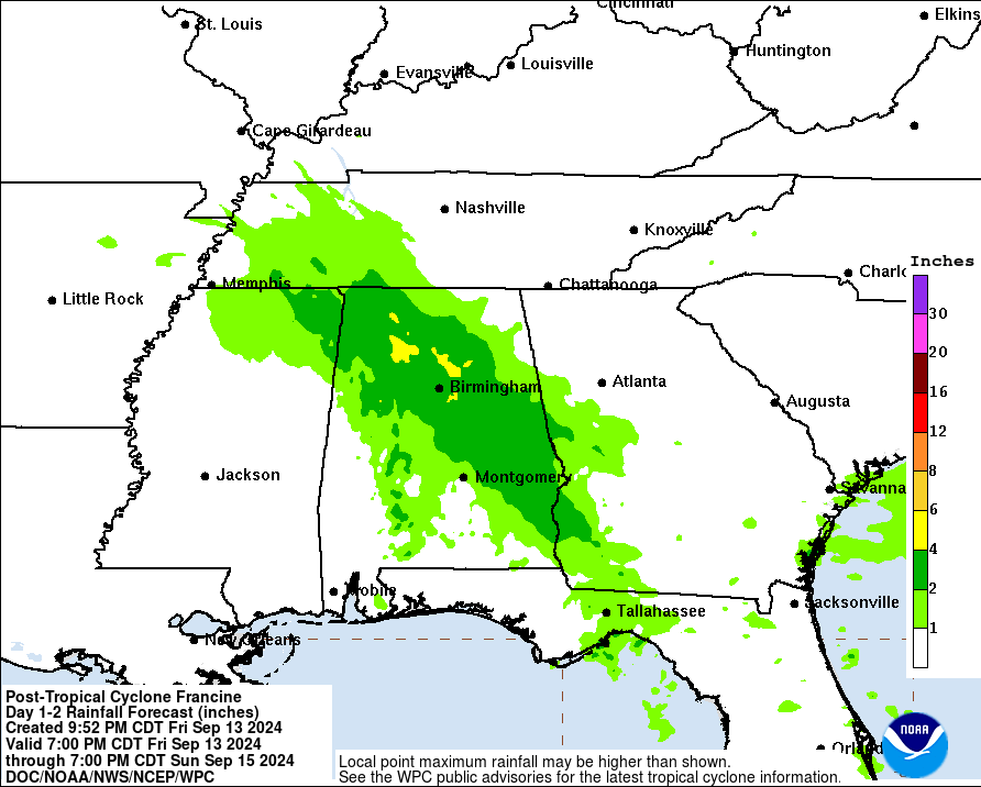
re: Francine - Landfall in Terrebonne Parish as CAT 2 100 mph
Posted on 9/11/24 at 10:00 am to MorbidTheClown

Posted on 9/11/24 at 10:00 am to MorbidTheClown
quote:
landfall now later?
nope. still looking at landfall just after 6pm CST or so.
 0
0


Posted on 9/11/24 at 10:00 am to friendlyobservation
Actually I'm refreshing the page and this might be the 10am post


This post was edited on 9/11/24 at 10:02 am
Posted on 9/11/24 at 10:00 am to Impotent Waffle
A best case for Baton Rouge is we continue to skirt the west side which means less rain and less wind, though we will still get some substantial wind gusts.
Posted on 9/11/24 at 10:00 am to urinetrouble
quote:
They actually moved it slightly west, despite an opposite trend from the 12z models.
Maybe later in the forecast but I don't see that at landfall.
Posted on 9/11/24 at 10:01 am to LSUZombie
does the track change when it hits landfall?or, it's it locked in at the current track?
Posted on 9/11/24 at 10:02 am to MorbidTheClown
Morgan City and Berwick with 11am curfew today until 6am Thursday.
Posted on 9/11/24 at 10:02 am to Magnus
I've been following stuff for a long time and I swear I'm smart enough not to still be confused by model runs and Zulu time.

Posted on 9/11/24 at 10:02 am to LSUZombie
quote:
best case for Baton Rouge is we continue to skirt the west side which means less rain and less wind, though we will still get some substantial wind gusts.
Yup! Guess time is gonna tell. Either way I am expecting trees down and loss of power.
Posted on 9/11/24 at 10:02 am to friendlyobservation

Posted on 9/11/24 at 10:02 am to slackster
quote:
Maybe later in the forecast but I don't see that at landfall.
I think people are confusing the narrowing of the cone for a western shift. for instance, new orleans is now out of the cone, but that's because the storm is closer to the coast and thus the cone is narrow just inland.
Posted on 9/11/24 at 10:02 am to BilbeauTBaggins
I meant more the one that showed the route with all the cities around it. I think slackster posts it all the time. 
Posted on 9/11/24 at 10:02 am to deltaland
quote:
deltaland

Posted on 9/11/24 at 10:03 am to OldManRiver
Graf has a place it’s been known to be good for short term rainfall. I’m talking about predicting rainfall 12-24 hours out. It shouldn’t be used for hurricane info. It got lucky in Laura by calling out a west shift and a RI and ever since then Perillo thinks it’s the gospel and Fradella is the same.
Posted on 9/11/24 at 10:03 am to friendlyobservation
you can use the interactive map and zoom in
Posted on 9/11/24 at 10:03 am to TH03
Good news 6 hours and no further strengthening and now less than 8 hours to landfall with hopeful shear to deal w
Posted on 9/11/24 at 10:04 am to friendlyobservation
quote:
I would trust NHC they know what they doing.
Well…yeah
They are the ones controlling all this with their cloud seeding and weather guns.
Posted on 9/11/24 at 10:04 am to urinetrouble
What does that even mean? They have stuck to a track have been money so far.
Posted on 9/11/24 at 10:05 am to ShoeBang
Sup neighbor

Posted on 9/11/24 at 10:06 am to SWLA92
Tickfaw River is at flood stage per LPSO.

 Page 314 of 492

Popular
Back to top