- My Forums
- Tiger Rant
- LSU Recruiting
- SEC Rant
- Saints Talk
- Pelicans Talk
- More Sports Board
- Fantasy Sports
- Golf Board
- Soccer Board
- O-T Lounge
- Tech Board
- Home/Garden Board
- Outdoor Board
- Health/Fitness Board
- Movie/TV Board
- Book Board
- Music Board
- Political Talk
- Money Talk
- Fark Board
- Gaming Board
- Travel Board
- Food/Drink Board
- Ticket Exchange
- TD Help Board
Customize My Forums- View All Forums
- Show Left Links
- Topic Sort Options
- Trending Topics
- Recent Topics
- Active Topics
Started By
Message
 2
2

Posted on 10/8/20 at 11:13 pm to FLBooGoTigs1


Posted on 10/8/20 at 11:13 pm to NorthEndZone
quote:
Update: West Gulf Buoy is in northern eyewall...34 foot significant wave height...
TWC said 42002 recorded 90mph gust
Posted on 10/8/20 at 11:13 pm to FLBooGoTigs1
quote:
Red Stick Ready
@RedStickReady
High water has been reported at
Greenwell Springs Rd at Frenchtown Rd and Greenwell Springs Rd at N Flannery. Please exercise extreme caution when traveling in the area.

Posted on 10/8/20 at 11:13 pm to slackster
Didn't think it'd be popping off like this around Baton Rouge tonight.
not being a smartarse...really tropical cluster frick rain
not being a smartarse...really tropical cluster frick rain
This post was edited on 10/8/20 at 11:18 pm

Posted on 10/8/20 at 11:14 pm to LaBR4
It's been absolutely dumping in St. George.

Posted on 10/8/20 at 11:14 pm to LSUJML
Tornado WARNING
EBR/EAST FELICIANA/ST.HELENA
Gonna be loooooong night
EBR/EAST FELICIANA/ST.HELENA
Gonna be loooooong night

Posted on 10/8/20 at 11:15 pm to LaBR4
Damn, tornado warnings already.
Posted on 10/8/20 at 11:16 pm to Bobby OG Johnson
Pressure is down to 950mb on the last confirmed pass.
Posted on 10/8/20 at 11:16 pm to Bayou_Tiger_225
quote:
Take cover now if you are in northern Livingston and Southwest St.Helena Parishes between Watson and Montpelier!
Posted on 10/8/20 at 11:17 pm to Bobby OG Johnson
Heaviest Rain in Baton Rouge so far right now, absolute downpour
Posted on 10/8/20 at 11:19 pm to LaBR4
quote:
Didn't think it'd be popping off like this around Baton Rouge tonight.
not being a smartarse...really tropical cluster frick rain
Roughly 12 hours ago dukke v said BR had nothing to worry about, so this was always in the cards.
Posted on 10/8/20 at 11:20 pm to Bobby OG Johnson
Local news in BR on. Jay Grimes=sleeves rolled
Posted on 10/8/20 at 11:22 pm to slackster
quote:
dukke v
He gave BR a death sentence.
Posted on 10/8/20 at 11:22 pm to tigahfan747
quote:
Local news in BR on. Jay Grimes=sleeves rolled


Posted on 10/8/20 at 11:22 pm to LaBR4
When I checked at 11:06 it had slacked off
It’s pouring way heavier now
It’s pouring way heavier now

Posted on 10/8/20 at 11:22 pm to tigahfan747
Is he wearing his black jeans?
Posted on 10/8/20 at 11:23 pm to Bobby OG Johnson
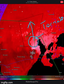
That's a good looking couplet for a tropical system tornado.
Actually looks better now than when you posted it.
Actually looks better now than when you posted it.
This post was edited on 10/8/20 at 11:24 pm
Posted on 10/8/20 at 11:23 pm to pistolpete23
quote:
TWC said 42002 recorded 90mph gust
Up to 98 mph gust now

 Page 402 of 601

Popular
Back to top