- My Forums
- Tiger Rant
- LSU Recruiting
- SEC Rant
- Saints Talk
- Pelicans Talk
- More Sports Board
- Fantasy Sports
- Golf Board
- Soccer Board
- O-T Lounge
- Tech Board
- Home/Garden Board
- Outdoor Board
- Health/Fitness Board
- Movie/TV Board
- Book Board
- Music Board
- Political Talk
- Money Talk
- Fark Board
- Gaming Board
- Travel Board
- Food/Drink Board
- Ticket Exchange
- TD Help Board
Customize My Forums- View All Forums
- Show Left Links
- Topic Sort Options
- Trending Topics
- Recent Topics
- Active Topics
Started By
Message
re: Delta Moves On...Cleanup Begins
Posted on 10/8/20 at 6:33 pm to gaetti15
Posted on 10/8/20 at 6:33 pm to gaetti15
quote:
yah they fly at different levels to prevent crashes.
Pretty damn cool
I posted a link to a Twitter video earlier where they passed within seeing distance of each other in the eye.
 0
0

Posted on 10/8/20 at 6:33 pm to gaetti15
1 plane penetrating eyewall now from the north
other plane just turned towards the eye from the outer ends of the storm... making a NE to SW run
other plane just turned towards the eye from the outer ends of the storm... making a NE to SW run
Posted on 10/8/20 at 6:35 pm to rt3
quote:
1 plane penetrating eyewall now from the north
other plane just turned towards the eye from the outer ends of the storm... making a NE to SW run
Air Traffic Control to the eye of Delta, please.
Posted on 10/8/20 at 6:38 pm to LegendInMyMind
highest SFMR reading I recall seeing of late is 95 kts or 110 MPH
This post was edited on 10/8/20 at 6:39 pm
Posted on 10/8/20 at 6:44 pm to rt3
quote:
highest SFMR reading I recall seeing of late is 95 kts or 110 MPH
That’s a bit stronger, earlier it was 90 Kts when they upgraded to a 3. They took the flight level and SFMR readings and extrapolated it
Posted on 10/8/20 at 6:45 pm to deltaland
quote:
They took the flight level and SFMR readings and extrapolated it
wish I understood this process sometimes

Posted on 10/8/20 at 6:47 pm to rt3
We getting some rain in BR. Kids are playing in it...
Posted on 10/8/20 at 6:47 pm to Hamma1122
quote:
Northwestern part of storm looks to be strongest
The shear that is supposed to weaken the storm will be southwesterly so be looking for the West and Southern portions to start looking less organized whenever the storm does encounter the shear. That’s when you’ll know it will start weakening, you’ll see the convection collapse as it tries to expand outward and the shear blows it back eastward

Posted on 10/8/20 at 6:47 pm to roguetiger15
quote:
I’m starting to get this sinking feeling that between now and 6am this storm is going to start banking East.
Wishcasting depression sinking in
Posted on 10/8/20 at 6:47 pm to deltaland
@pppapin with a good break down of the expected shear:
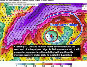
quote:
Looking at the next 36h with #Delta, one thing that seems clear is that vertical wind shear (VWS) will increase prior to #Louisiana landfall. The current ~10kt of VWS now is forecast to increase to >35kt in 36h.
This likely will lead to weakening, but Delta will remain very dangerous. LINK
Posted on 10/8/20 at 6:48 pm to rt3
quote:
wish I understood this process sometimes
I think it tends to inflate the strength a bit but I think they do it when the storm is strengthening to account for the time between updates. Basically they figure some of the flight level winds will reach surface before the next recon data so they add a little to it
Posted on 10/8/20 at 6:48 pm to Impotent Waffle
now I see 100 kt unflagged SFMR reading from the plane that dove in from the north

Posted on 10/8/20 at 6:49 pm to Cosmo
Is that dry air on the NNE side of Delta? Last GEO frame.
Posted on 10/8/20 at 6:49 pm to rt3
951.3 millibars also but they sometimes adjust it,
Posted on 10/8/20 at 6:50 pm to TigerNAtux
If theres gonna be dry air should be getting sucked in from S/SE
Posted on 10/8/20 at 6:50 pm to deltaland
quote:
The shear that is supposed to weaken the storm will be southwesterly so be looking for the West and Southern portions to start looking less organized whenever the storm does encounter the shear. That’s when you’ll know it will start weakening, you’ll see the convection collapse as it tries to expand outward and the shear blows it back eastward
hopefully some dry air will be included with that shear
Posted on 10/8/20 at 6:51 pm to Cosmo
Gotcha’. Just looks puny on the north side in that last frame.
Posted on 10/8/20 at 6:51 pm to NorthEndZone
They'll drop a sonde into the center to get the exact pressure. The extrap from the plane has been running too low but I'd think 955-954 mb seems reasonable with what we're seeing in terms of wind.
Posted on 10/8/20 at 6:52 pm to rt3
the plane that was coming from the north... looked like it expected the storm to be more west and then had to go back east a bit as it got to the eye to find the exact center
Posted on 10/8/20 at 6:52 pm to rt3
Delta looking ragged on the IR satilite loop

 Page 374 of 601

Popular
Back to top