- My Forums
- Tiger Rant
- LSU Recruiting
- SEC Rant
- Saints Talk
- Pelicans Talk
- More Sports Board
- Coaching Changes
- Fantasy Sports
- Golf Board
- Soccer Board
- O-T Lounge
- Tech Board
- Home/Garden Board
- Outdoor Board
- Health/Fitness Board
- Movie/TV Board
- Book Board
- Music Board
- Political Talk
- Money Talk
- Fark Board
- Gaming Board
- Travel Board
- Food/Drink Board
- Ticket Exchange
- TD Help Board
Customize My Forums- View All Forums
- Show Left Links
- Topic Sort Options
- Trending Topics
- Recent Topics
- Active Topics
Started By
Message
 0
0

Posted on 9/17/20 at 4:33 pm to Duke
quote:
NOAA: Alright guys, you just have a research mission into Teddy today. Here's the flight plan.
Flight Crew: It just says "eyewall".
NOAA: Have fun guys.
Posted on 9/17/20 at 4:34 pm to Duke
quote:
Nice to be able to post one of these when it's just got open water all around.
And one that actually looks like a hurricane for a change.
Posted on 9/17/20 at 4:35 pm to Duke
damn
This post was edited on 9/17/20 at 4:36 pm

Posted on 9/17/20 at 4:36 pm to Duke
didnt see the euro posted

Posted on 9/17/20 at 4:37 pm to Who_Dat_Tiger
quote:
didnt see the euro posted
Thanks for posting. That really clears things up.
Posted on 9/17/20 at 4:37 pm to Who_Dat_Tiger
Always got to have the obligatory right up morgan city pooper as one of the strongest hurricanes in the ensembles. When in doubt target morgan city. It's an inside joke with the models for sure.

seriously though, do models project based on historic data at all?
seriously though, do models project based on historic data at all?
This post was edited on 9/17/20 at 4:39 pm
Posted on 9/17/20 at 5:02 pm to Who_Dat_Tiger
quote:
didnt see the euro posted
I did post it, just out to 120 hours instead of the whole thing. For a reason. There's so much uncertainty in this system that it's too far out to even take the ensemble runs seriously past the first couple of days.
In general though, we're getting to the time of the year where I don't want a tropical cyclone hanging out SW of my location.
Posted on 9/17/20 at 5:20 pm to Duke
quote:
Ensembles really clearing things up for 90L
Models are in better agreement on what might happen over the next few days now that the GFS has dropped the deeper trough.

Models now show the system drifting NNE over the next couple of days as the trough passes to the north and then drifting back WSW towards the coast. Big question is how close does it get to the coast? A deeper system will probably eventually get lifted off to the NE towards the Northern Gulf Coast and a weaker shallower system probably gets pushed into Texas and dissipates before lifting NE.
Actually, pretty good agreement now b/w the 18z GFS and 12z Euro trough 90ish hours.


Posted on 9/17/20 at 5:26 pm to rds dc
quote:
shallower system probably gets pushed into Texas
Rummy just went from 6 to midnight.
Posted on 9/17/20 at 5:37 pm to rds dc
This system could be another serious rainfall threat. Most recent GFS stalls it around the Corpus Christi area for nearly 4 days.

Posted on 9/17/20 at 5:40 pm to slackster
Harvey II
Posted on 9/17/20 at 5:42 pm to The Egg
That's gotta be a bingo lol, although i was thinking the same thing with this potentially being a Harvey.
Posted on 9/17/20 at 5:50 pm to lsuman25
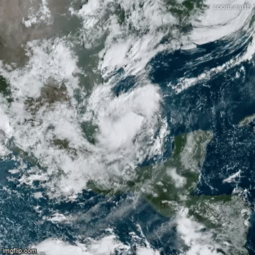
NHC will initiate advisories on Tropical Depression Twenty Two, located in the southwestern Gulf of Mexico, at 600 PM CDT (2300 UTC).
Posted on 9/17/20 at 5:55 pm to rds dc
Offically TD 22. It is technically a closed low, if an elongated one.
Also was just look through the GFS from this morning and the 18z and...
rds has already covered it and better than I was going to. So just go up the page and read that one.
Also was just look through the GFS from this morning and the 18z and...
quote:
Models are in better agreement on what might happen over the next few days now that the GFS has dropped the deeper trough.
rds has already covered it and better than I was going to. So just go up the page and read that one.

Posted on 9/17/20 at 5:59 pm to Duke
Posted on 9/17/20 at 6:01 pm to Duke
...TROPICAL DEPRESSION FORMS OVER THE SOUTHWESTERN GULF OF MEXICO... ...EXPECTED TO MOVE SLOWLY OVER THE WESTERN GULF INTO EARLY NEXT WEEK...
6:00 PM CDT Thu Sep 17
Location: 21.9°N 94.3°W
Moving: NE at 5 mph
Min pressure: 1005 mb
Max sustained: 35 mph
6:00 PM CDT Thu Sep 17
Location: 21.9°N 94.3°W
Moving: NE at 5 mph
Min pressure: 1005 mb
Max sustained: 35 mph
Posted on 9/17/20 at 6:02 pm to lsuman25
quote:
NHC will initiate advisories on Tropical Depression Twenty Two, located in the southwestern Gulf of Mexico, at 600 PM CDT (2300 UTC).
Should get comes at 10.
Posted on 9/17/20 at 6:03 pm to lsuman25


Posted on 9/17/20 at 6:13 pm to lsuman25
So they're pretending the gfs doesn't exist

 Page 15 of 63

Popular
Back to top