- My Forums
- Tiger Rant
- LSU Recruiting
- SEC Rant
- Saints Talk
- Pelicans Talk
- More Sports Board
- Fantasy Sports
- Golf Board
- Soccer Board
- O-T Lounge
- Tech Board
- Home/Garden Board
- Outdoor Board
- Health/Fitness Board
- Movie/TV Board
- Book Board
- Music Board
- Political Talk
- Money Talk
- Fark Board
- Gaming Board
- Travel Board
- Food/Drink Board
- Ticket Exchange
- TD Help Board
Customize My Forums- View All Forums
- Show Left Links
- Topic Sort Options
- Trending Topics
- Recent Topics
- Active Topics
Started By
Message

 0
0

Posted on 7/8/24 at 5:59 pm to Cosmo
I looked into the hurricanes that produced the most tornadoes.
Per TWC:
5. Hurricane Andrew (1992): 61 Tornadoes
4. Hurricane Rita (2005): 89 Tornadoes
3. Hurricane Frances (2004): 103 Tornadoes
2. Hurricane Beulah (1967): 115 Tornadoes
1. Hurricane Ivan (2004): 120 Tornadoes
Per TWC:
5. Hurricane Andrew (1992): 61 Tornadoes
4. Hurricane Rita (2005): 89 Tornadoes
3. Hurricane Frances (2004): 103 Tornadoes
2. Hurricane Beulah (1967): 115 Tornadoes
1. Hurricane Ivan (2004): 120 Tornadoes
Posted on 7/8/24 at 6:00 pm to LegendInMyMind
They are up to 56 tornado warnings now.
Posted on 7/8/24 at 6:02 pm to beaverfever
Rare but not uncommon. You have to go back some years...and then some years before that etc...to find it like today...Most of the time tornados that spawn from hurricanes are small and short lived. They form quick and die pretty quick.
This post was edited on 7/8/24 at 6:03 pm
Posted on 7/8/24 at 6:03 pm to Lsut81
Same number!

Posted on 7/8/24 at 6:04 pm to Tomherman
Well boys, Mount Driskill might lose a couple of the lifts with all these tornado warnings
Dunno what that means for the winter season
Dunno what that means for the winter season
Posted on 7/8/24 at 6:04 pm to LegendInMyMind
Guess we should have figured Beryl would have been a tornadic efficient storm producer.

Posted on 7/8/24 at 6:04 pm to LegendInMyMind
quote:
LegendInMyMind
Have pretty much all my family that lives in Central Arkansas, is the environment over that area any different than NWLA and SWAR when it comes to supercell and tornadic development?
Only asking because the 14z outlook specifically shows that area of NWLA/SWAR as a hotspot for tornado development, but then it lessens as it enters further into Arkansas. Are the conditions really that much different or is it the fact that it's getting dark and the heat isn't there to feed supercell development? Or is it all a load of crap and it's just as likely that supercells and tornados develop over central Arkansas?
ETA: this is in reference to the Nadocast 14z day outlook that has been posted here several times
This post was edited on 7/8/24 at 6:10 pm

Posted on 7/8/24 at 6:09 pm to Water
quote:
Well boys, Mount Driskill might lose a couple of the lifts with all these tornado warnings
Last day to purchase a discounted season pass is 7/31.
Posted on 7/8/24 at 6:12 pm to LegendInMyMind
quote:
I looked into the hurricanes that produced the most tornadoes.
Per TWC:
5. Hurricane Andrew (1992): 61 Tornadoes
4. Hurricane Rita (2005): 89 Tornadoes
3. Hurricane Frances (2004): 103 Tornadoes
2. Hurricane Beulah (1967): 115 Tornadoes
1. Hurricane Ivan (2004): 120 Tornadoes
Hilda in 1964 was pretty bad for tornadoes in the name of strength.
One of the largest was an F4 that plowed through Larose, Louisiana. It killed 22 people and injured over 165 others. The tornado was also one of only two F4s known to have been produced by a tropical cyclone, the other having occurred during Hurricane Carla in 1961.

Posted on 7/8/24 at 6:14 pm to Tarps99
quote:
One of the largest was an F4 that plowed through Larose, Louisiana. It killed 22 people and injured over 165 others. The tornado was also one of only two F4s known to have been produced by a tropical cyclone, the other having occurred during Hurricane Carla in 1961.
I read up on that one a while back. It may have been Tornado Talk that did a write up on it. Yeah, you don't get tornadoes that strong from any tropical system very often, thankfully.
Posted on 7/8/24 at 6:17 pm to LegendInMyMind
If anyone gets a hold of a Centerpoint restoration plan/map, please post a link or an image.
Signal is spotty and haven’t seen anything posted online yet.
Signal is spotty and haven’t seen anything posted online yet.
Posted on 7/8/24 at 6:20 pm to AGGIES
You won't find one. They don't update shite
Posted on 7/8/24 at 6:21 pm to RazorBroncs
quote:
Have pretty much all my family that lives in Central Arkansas, is the environment over that area any different than NWLA and SWAR when it comes to supercell and tornadic development?
I haven't looked all that closely up that way, but just at a glance the overall environment doesn't look nearly as good as what was in NW LA and NE TX today. Barrel starts to get picked up by the front and moves East, losing a lot of that spin. NE Louisiana had decent shear in place today ahead of the storm that helped it and a little more instability to work with. Things get messy as this moves into AR. There's always a possibility, but I don't think it will be near to the scale we've seen so far today, especially the farther north you get.
Posted on 7/8/24 at 6:22 pm to rds dc
Hope everyone made it through with minimal damage.
We lost power around 630am. And other than a bunch of my neighbor's limbs in the backyard, everything seems to be ok.
We lost power around 630am. And other than a bunch of my neighbor's limbs in the backyard, everything seems to be ok.
Posted on 7/8/24 at 6:26 pm to Tarps99
I have some distant relatives from down the Bayou, and they still talk about that Hilda tornado. They never mention the hurricane, just the tornado that wrecked that area.
Posted on 7/8/24 at 6:30 pm to Ghost of Colby
These are all the tornadoes produced by Hurricane Ivan between Sept. 15 and 18, 2004.
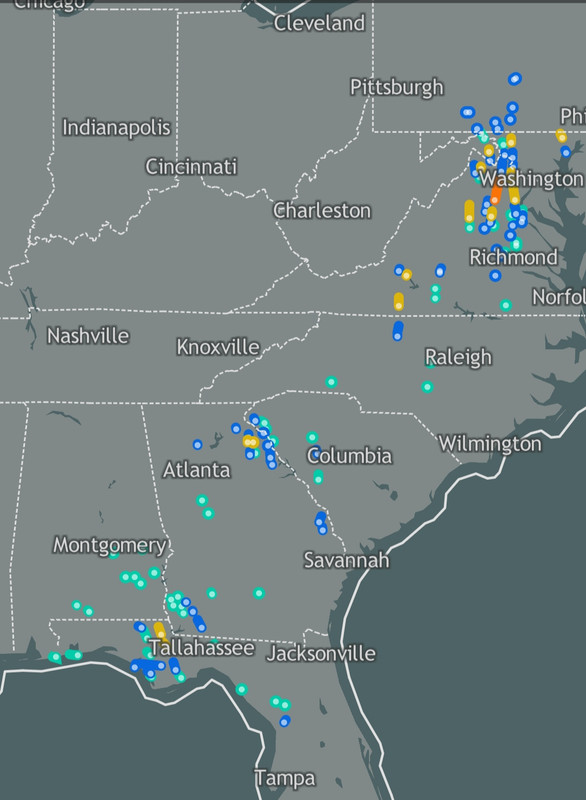
I'm wondering if the remnants of Ivan after it made its loop de loop voyage produced any tornadoes?
I'm wondering if the remnants of Ivan after it made its loop de loop voyage produced any tornadoes?

Posted on 7/8/24 at 6:31 pm to LegendInMyMind
Thank you very much for your hard work here during this. A lot of people really needed it.
You other guys that contributed as well.

You other guys that contributed as well.
Posted on 7/8/24 at 6:32 pm to LegendInMyMind
quote:
LegendInMyMind
Thank you sir.
As you replied I've noticed that we're down to 5 tornado warnings with none of them confirmed, just radar picking up rotation.
Beryl is definitely starting to disorganize and get ugly, it's cool to us amateur weather nerds to see how that front hanging out near south Missouri is impacting a fairly weak depression (now)

 Page 177 of 218

Popular
Back to top