- My Forums
- Tiger Rant
- LSU Recruiting
- SEC Rant
- Saints Talk
- Pelicans Talk
- More Sports Board
- Fantasy Sports
- Golf Board
- Soccer Board
- O-T Lounge
- Tech Board
- Home/Garden Board
- Outdoor Board
- Health/Fitness Board
- Movie/TV Board
- Book Board
- Music Board
- Political Talk
- Money Talk
- Fark Board
- Gaming Board
- Travel Board
- Food/Drink Board
- Ticket Exchange
- TD Help Board
Customize My Forums- View All Forums
- Show Left Links
- Topic Sort Options
- Trending Topics
- Recent Topics
- Active Topics
Started By
Message

 0
0

Posted on 5/19/24 at 7:44 pm to Bobby OG Johnson

Posted on 5/19/24 at 7:45 pm to SWLA92
The irony being AMC playing Twister at this very moment.
Posted on 5/19/24 at 7:45 pm to Pedro
Stay safe pedro!

Posted on 5/19/24 at 7:45 pm to Bobby OG Johnson
Holy lord…
Posted on 5/19/24 at 7:45 pm to Bobby OG Johnson
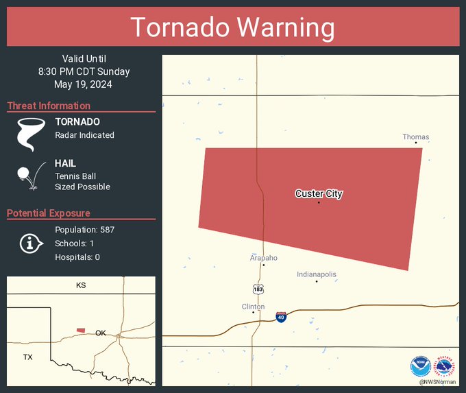
Reeds feed just cutoff he was pretty much in the middle of the storm near Custer City.
He’s back on
He’s back on
This post was edited on 5/19/24 at 7:46 pm
Posted on 5/19/24 at 7:47 pm to bubbaprohn
I think it may have one down.
This post was edited on 5/19/24 at 7:49 pm
Posted on 5/19/24 at 7:48 pm to LegendInMyMind
That cell is just north of me. I'm in park city. Several work colleagues live in Newton though, hoping it dies down before it gets there
Posted on 5/19/24 at 7:49 pm to LegendInMyMind
That storm now has a confirmed tornado in it. Stay safe Pedro

Posted on 5/19/24 at 7:49 pm to Bobby OG Johnson
Not seeing a clear CC drop on the Oklahoma tornado as of yet. Hopefully it’s in open country.
Posted on 5/19/24 at 7:49 pm to LegendInMyMind
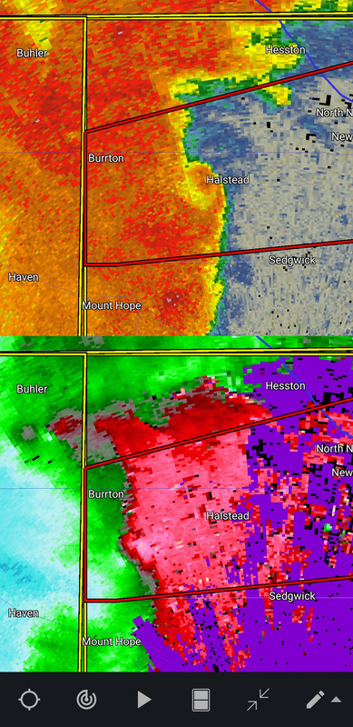
Yeah, the line near Halstead, KS probably has a tornado down right now.
This post was edited on 5/19/24 at 7:50 pm
Posted on 5/19/24 at 7:50 pm to SWLA92
Storm is moving at 70 mph!
quote:
BULLETIN - EAS ACTIVATION REQUESTED
Tornado Warning
National Weather Service Wichita KS
744 PM CDT Sun May 19 2024
The National Weather Service in Wichita has issued a
* Tornado Warning for...
Harvey County in south central Kansas...
* Until 830 PM CDT.
* At 744 PM CDT, a severe thunderstorm capable of producing a tornado
was located near Halstead, moving northeast at 70 mph.
HAZARD...Tornado and half dollar size hail.
SOURCE...Radar indicated rotation.
IMPACT...Flying debris will be dangerous to those caught without
shelter. Mobile homes will be damaged or destroyed.
Damage to roofs, windows, and vehicles will occur. Tree
damage is likely.
* This dangerous storm will be near...
Newton, Halstead, and North Newton around 750 PM CDT.
Walton around 800 PM CDT.
Other locations impacted by this tornadic thunderstorm include Newton
Airport.
Posted on 5/19/24 at 7:51 pm to LegendInMyMind
The OK storm will pass right over a weather station if it doesn't turn.
Posted on 5/19/24 at 7:52 pm to Bobby OG Johnson
Posted on 5/19/24 at 7:52 pm to LegendInMyMind
One of my neighbors just started cutting their grass 
Posted on 5/19/24 at 7:53 pm to Pedro
Tornado Emergency now on the OK srorm.
Posted on 5/19/24 at 7:55 pm to Pedro
quote:
One of my neighbors just started cutting their grass
I just felt like cutting

Posted on 5/19/24 at 7:56 pm to Bobby OG Johnson
Legit heard the mower cut on and was like “the hell?” walked out and sure enough theyre there pushing away.
Posted on 5/19/24 at 7:57 pm to Bobby OG Johnson
Downgraded to Radar Indicated but would still treat it as OTG with its history for now
Posted on 5/19/24 at 7:57 pm to Bobby OG Johnson
New radar scan looks like it might be trying to get back on ground

 Page 3 of 10

Popular
Back to top