- My Forums
- Tiger Rant
- LSU Recruiting
- SEC Rant
- Saints Talk
- Pelicans Talk
- More Sports Board
- Fantasy Sports
- Golf Board
- Soccer Board
- O-T Lounge
- Tech Board
- Home/Garden Board
- Outdoor Board
- Health/Fitness Board
- Movie/TV Board
- Book Board
- Music Board
- Political Talk
- Money Talk
- Fark Board
- Gaming Board
- Travel Board
- Food/Drink Board
- Ticket Exchange
- TD Help Board
Customize My Forums- View All Forums
- Show Left Links
- Topic Sort Options
- Trending Topics
- Recent Topics
- Active Topics
Started By
Message
re: Another Derecho currently ongoing in Kansas, 90+ winds and large hail
Posted on 5/19/24 at 7:17 pm to LegendInMyMind

Posted on 5/19/24 at 7:17 pm to LegendInMyMind
Yea honestly as long as there’s no rotation or just something completely ridiculous I should be fine where I am. More so just worried about the thunder given the current baby situation 
 1
1

Posted on 5/19/24 at 7:19 pm to Pedro
I getcha. You're worried about what may set off the ticking time bomb.
Posted on 5/19/24 at 7:21 pm to LegendInMyMind
Yuuuup. Wife’s in there working her magic right now though so we may survive.
Watching the trees in my yard out back I wouldn’t be surprised if we’re getting some 50ish mph gusts right now. It’s kicking out there.
Watching the trees in my yard out back I wouldn’t be surprised if we’re getting some 50ish mph gusts right now. It’s kicking out there.
This post was edited on 5/19/24 at 7:22 pm
Posted on 5/19/24 at 7:25 pm to Pedro
That cell in Oklahoma is looking potent
Posted on 5/19/24 at 7:28 pm to Pedro
Y'all hang in there. Hate y'all are having to go thru this shite.
Posted on 5/19/24 at 7:28 pm to Pedro
It has a big hail core to the north of the potential tornado area
Posted on 5/19/24 at 7:28 pm to Pedro
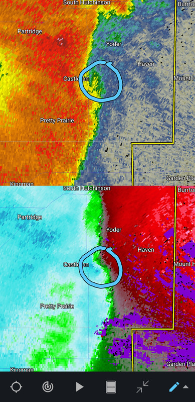
A bit of rotation trying to form around Castleton.
This post was edited on 5/19/24 at 7:31 pm
Posted on 5/19/24 at 7:31 pm to LegendInMyMind
That cell south of Pratt is starting to get its act together
I have a buddy in the path of that one you’re mentioning legend. About to give him a heads up.
I have a buddy in the path of that one you’re mentioning legend. About to give him a heads up.
This post was edited on 5/19/24 at 7:33 pm
Posted on 5/19/24 at 7:32 pm to LegendInMyMind
The OK storm:
Loading Twitter/X Embed...
If tweet fails to load, click here.This post was edited on 5/19/24 at 7:34 pm
Posted on 5/19/24 at 7:36 pm to LegendInMyMind
50mph winds in the inflow region around the OK storm.
We will eventually get a cell merger with the two OK storms. Will be interesting to see what happens.
We will eventually get a cell merger with the two OK storms. Will be interesting to see what happens.
This post was edited on 5/19/24 at 7:37 pm
Posted on 5/19/24 at 7:37 pm to LegendInMyMind
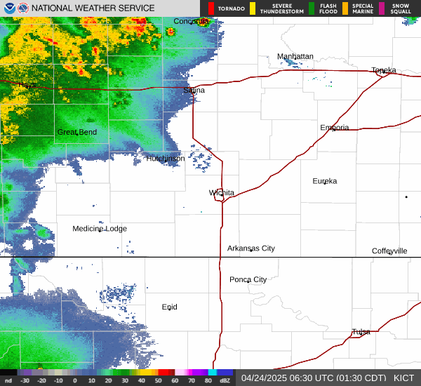
Severe T-storm Warning for Wichita for 80 mph winds and half-dollar hail
quote:
The National Weather Service in Wichita has issued a
* Severe Thunderstorm Warning for... Sedgwick County in south central Kansas... Harvey County in south central Kansas...
* Until 830 PM CDT.
* At 732 PM CDT, severe thunderstorms were located along a line extending from near Hutchinson to near Pretty Prairie to 6 miles southwest of Kingman, moving east at 55 mph.
HAZARD...80 mph wind gusts and half dollar size hail.
SOURCE...Radar indicated.
IMPACT...Flying debris will be dangerous to those caught without shelter. Mobile homes will be heavily damaged. Expect considerable damage to roofs, windows, and vehicles. Extensive tree damage and power outages are likely.
* Locations impacted include... Wichita, Derby, Newton, Haysville, Park City, Valley Center, Bel Aire, Mulvane, Goddard, Hesston, Maize, Clearwater, Cheney, Halstead, North Newton, Sedgwick, Colwich, Burrton, Garden Plain, and Mount Hope.
Posted on 5/19/24 at 7:38 pm to LegendInMyMind
PDS declared for the tornado warned storm near Arapaho
Posted on 5/19/24 at 7:40 pm to SWLA92
I think that's the first one it has put down.
Posted on 5/19/24 at 7:40 pm to NorthEndZone
Posted on 5/19/24 at 7:41 pm to NorthEndZone


Posted on 5/19/24 at 7:41 pm to LegendInMyMind
Jeff Piotrowski has a massive tornado on his live stream.
Loading Twitter/X Embed...
If tweet fails to load, click here.This post was edited on 5/19/24 at 7:43 pm

Posted on 5/19/24 at 7:43 pm to Pedro
It still has that area of rotation north of Mount Hope.

Posted on 5/19/24 at 7:43 pm to Pedro
Posted on 5/19/24 at 7:44 pm to Roll Tide Ravens
Possibly a mile wide tornado according to Max Velocity

 Page 2 of 10

Popular
Back to top