- My Forums
- Tiger Rant
- LSU Recruiting
- SEC Rant
- Saints Talk
- Pelicans Talk
- More Sports Board
- Fantasy Sports
- Golf Board
- Soccer Board
- O-T Lounge
- Tech Board
- Home/Garden Board
- Outdoor Board
- Health/Fitness Board
- Movie/TV Board
- Book Board
- Music Board
- Political Talk
- Money Talk
- Fark Board
- Gaming Board
- Travel Board
- Food/Drink Board
- Ticket Exchange
- TD Help Board
Customize My Forums- View All Forums
- Show Left Links
- Topic Sort Options
- Trending Topics
- Recent Topics
- Active Topics
Started By
Message

 0
0

Posted on 10/27/20 at 5:53 am to rmnldr
quote:
Are they not issuing warnings just yet to avoid waking people or am I missing something?
Not sure what's happening. NHC put out warnings that included metro New Orleans. Storm surge warnings too and the whole parish should get an alert on those. Guess they might be holding them back till later after people bitched the last two times.

Posted on 10/27/20 at 5:54 am to TDsngumbo
This is unfricking believable

Posted on 10/27/20 at 5:55 am to Jim Rockford
quote:
With it pushing back the Rossby Wave, good chance the track will be more west.
Also, a better chance intensity will be higher than currently anticipated.
Wtf is the Rossby Wave? Sorry, I just woke up and this is the first I’m seeing that.
This post was edited on 10/27/20 at 5:55 am

Posted on 10/27/20 at 5:55 am to TDsngumbo
Seems like the track moves east each update.
Posted on 10/27/20 at 5:57 am to East Coast Band
quote:
Seems like the track moves east each update
I mean I wouldn't complain if it did, but im not seeing any part of an H movement east.
Posted on 10/27/20 at 5:59 am to East Coast Band
I think it's the approach they have it coming in honestly.
Posted on 10/27/20 at 6:02 am to TDsngumbo
quote:
Wtf is the Rossby Wave?
It's a fancy way of referring to the upper low we've been talking about that's coming in from the west.
The argument he appears to be making is the outflow will push back a little and further delay the upper low, which keeps the ridge in place longer and forces things farther west.
That does happen sometimes but typically it's on a pretty weak trough or ULL. Against a big dip in the jet stream? Kinda like sending a HS freshman team LB corps to stop Derrick Henry.
The question left is more east or west of New Orleans and how strong.
Posted on 10/27/20 at 6:02 am to lsuman25

HWRF little stronger than it's last run

Posted on 10/27/20 at 6:05 am to lsuman25
It is really strange how none of the schools that typically freak out are even saying they’re monitoring the storm about closures.
2 months ago every school south of Shreveport would have been closed for a week
2 months ago every school south of Shreveport would have been closed for a week

Posted on 10/27/20 at 6:06 am to TDsngumbo
Pretty impressive how far inland the tropical storm watch extends in Alabama:
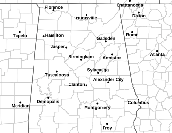

Posted on 10/27/20 at 6:08 am to Duke
Are we still expecting this to get sheared and the worst of it to be displaced to the East when it’s coming in? These models make it seem like being on the Western side of the center/eye won’t be much of an issue.
Posted on 10/27/20 at 6:10 am to Roll Tide Ravens
quote:
Pretty impressive how far inland the tropical storm watch extends in Alabama:
That's because the storm will be hauling arse.
Posted on 10/27/20 at 6:14 am to rmnldr
quote:
Are we still expecting this to get sheared and the worst of it to be displaced to the East when it’s coming in? These models make it seem like being on the Western side of the center/eye won’t be much of an issue.
The shear will be starting and the storm will be a little east loaded but it's not really going to be as beaten up as was thought two days ago.
The models are trending fairly strong, high end 1 all the way to high end 2 but with a compact core. Close enough to the center on the west and you'll get some good TS winds but the hurricane winds will likely be a fairly narrow swath just east and NE of the center of circulation.
Posted on 10/27/20 at 6:16 am to Duke
And there's the dickhead storm alert 
This post was edited on 10/27/20 at 6:17 am
Posted on 10/27/20 at 6:19 am to X123F45

Spiraly structure is spiraly. Pretty healthy looking for being over land tbh. Outflow has been increasing overnight. Wouldn't be surprised if it only needs 12 hours to reorganize some and get to strengthening again. Shear has all but disappeared at this point.
quote:
And there's the dickhead storm alert
Haven't gotten mine yet. Sadness.
Posted on 10/27/20 at 6:21 am to Duke
Eagerly awaiting the hurricane warning. none here
Posted on 10/27/20 at 6:21 am to LSU-MNCBABY
quote:
It is really strange how none of the schools that typically freak out are even saying they’re monitoring the storm about closures.
Don’t worry, it’s coming today. It’s also going to affect a much smaller area than most storms. I wouldn’t expect any cancellations from Baton Rouge on west. Mostly just Orleans metro to SW Mississippi.
This post was edited on 10/27/20 at 6:26 am
Posted on 10/27/20 at 6:25 am to Jwho77
quote:
'll say, if you only watched the WWLTV 10 p.m. report, you'd not be worried right now.
The wwl report looks to be more concern for Venice and Miss coast and maybe alabama coast. Nola on the west side.
Not projecting anything beyond a cat1. Most weather to the East.
Posted on 10/27/20 at 6:25 am to SippyCup
quote:
Don’t worry, it’s coming today.

 Page 53 of 228

Popular
Back to top