- My Forums
- Tiger Rant
- LSU Recruiting
- SEC Rant
- Saints Talk
- Pelicans Talk
- More Sports Board
- Fantasy Sports
- Golf Board
- Soccer Board
- O-T Lounge
- Tech Board
- Home/Garden Board
- Outdoor Board
- Health/Fitness Board
- Movie/TV Board
- Book Board
- Music Board
- Political Talk
- Money Talk
- Fark Board
- Gaming Board
- Travel Board
- Food/Drink Board
- Ticket Exchange
- TD Help Board
Customize My Forums- View All Forums
- Show Left Links
- Topic Sort Options
- Trending Topics
- Recent Topics
- Active Topics
Started By
Message
re: Hurricane Nate - Moving Inland - Hurricane Season Over?
Posted on 10/5/17 at 9:41 am to rds dc
Posted on 10/5/17 at 9:41 am to rds dc
NOAA P3 is flying an ocean data mission over the Gulf today.

quote:
NOAA’s P3 aircraft is up in the air and headed to fly over the Gulf of Mexico. This flight took off from Lakeland Linder Regional Airport, Lakeland, FL at 10 AM ET (1400 UTC). The goal of this flight is to gather oceanic data. The ocean plays a role in the development of tropical cyclones. NOAA42 will fly and launch ocean probes that will collect data on the current ocean conditions. If a tropical cyclone passes over this area then we will also collect oceanic data afterward. This type of data collection allows us to see track how the ocean changes when a tropical weather system passes over it. Below is the flight track. The dot represents the launch locations of the ocean probes. The colors on the map below indicate the amount of ocean heat content in the water.
 2
2


Posted on 10/5/17 at 9:41 am to VABuckeye
so is this thing going to get torn apart?
Posted on 10/5/17 at 9:50 am to Adam4848
quote:
(-) + (-) + (-) = -
Did I do that math right?
weather you did or not, you got my drift
Posted on 10/5/17 at 9:51 am to Chad504boy
New track about to come out is right over New Orleans
quote:
89.5 29.5
Posted on 10/5/17 at 9:51 am to rds dc
From the 11:00 am update:
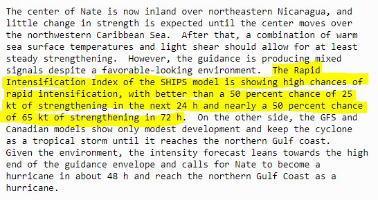
The center of Nate is now inland over northeastern Nicaragua, and
little change in strength is expected until the center moves over
the northwestern Caribbean Sea. After that, a combination of warm
sea surface temperatures and light shear should allow for at least
steady strengthening. However, the guidance is producing mixed
signals despite a favorable-looking environment. The Rapid
Intensification Index of the SHIPS model is showing high chances of
rapid intensification, with better than a 50 percent chance of 25
kt of strengthening in the next 24 h and nearly a 50 percent chance
of 65 kt of strengthening in 72 h. On the other side, the GFS and
Canadian models show only modest development and keep the cyclone
as a tropical storm until it reaches the northern Gulf coast.
Given the environment, the intensity forecast leans towards the high
end of the guidance envelope and calls for Nate to become a
hurricane in about 48 h and reach the northern Gulf Coast as a
hurricane.

Posted on 10/5/17 at 9:53 am to rds dc
frickKKKKK
Posted on 10/5/17 at 9:56 am to GEAUXmedic
quote:
New track about to come out is right over New Orleans
Luckily, it will be moving fast so flooding from rain won't be a major issue. Storm surge into SE Louisiana/New Orleans is what keeps me up at night...
Posted on 10/5/17 at 9:57 am to 50_Tiger

Posted on 10/5/17 at 9:57 am to rds dc
Flooding in NOLA is always a possibility. Even on a bright sunshiny day.
Posted on 10/5/17 at 9:58 am to rds dc
I feel like they are under-forecasting intensity.
Posted on 10/5/17 at 9:59 am to rds dc
Water is already high everywhere with the constant east wind we been having
Posted on 10/5/17 at 9:59 am to rds dc
Water levels are high across SE LA, so it won’t take much surge to flood some areas.
Posted on 10/5/17 at 9:59 am to GEAUXmedic
Hopefully they will be able to put the pump fires out by the time this thing arrives.

Posted on 10/5/17 at 10:00 am to LSU Wayne
quote:
Flooding in NOLA is always a possibility. Even on a bright sunshiny day
spilled drinks alone...
Posted on 10/5/17 at 10:01 am to rds dc
shite. I was avoiding the models this morning in hopes what Levi said last night was true. Looks like GFS won. The one time Louisiana wants the Euro to be right and has been all season it's...wrong. Awesome.
Anyways, some positives if this does hit NO is it seems projected shear once it leaves land seems to be slightly higher than projected. Also appears if it takes the GFS paths it will run into more problems in GOM that will prevent RI. It's still a possibility but doesn't look high right now. It's moving fast too not allowing it to collect itself and a direct hit on NO would likely be a very fast moving storm not allowing huge rainfall totals to accumulate.
The negatives appear to be the waters around Louisiana are unseasonably warm, the low near Florida is moving west which will probably wrap the dryer air around it instead of Nate and it's about to enter very warm water. Will be interesting to see how this thing moves and intensifies. Although you don't wish something like this on anyone we kinda need it to interact with Yucatan to minimize the strength. We don't know how organized it will be until it leaves the current movement over land. Good news there is the models seem to be in agreement it's not going to get too strong so let's hope that stays true. Well, other than the doomsday model that always does that.
Still seems to be some uncertainty on the path though it's starting to really tighten up. Again, just looks like a timing thing when it makes that turn. Could still turn before it even hits Louisiana but we'll just have to watch it. Hopefully NO doesn't get their pumps tested for this.
Posted on 10/5/17 at 10:03 am to rds dc
Posted on 10/5/17 at 10:06 am to burgeman
quote:
Because I thought this was the tracking thread with actual useful information.
People like to joke in these threads until it's a monster bearing down on them. Unfortunately it's just the way it goes in here sometimes.
Posted on 10/5/17 at 10:06 am to GEAUXmedic
damn...water is already up in the lake and surrounding areas. That track would have the east side pushing water directly into the lake. I guess we're actually fortunate that is coming more from the south rather than from the southeast.
Posted on 10/5/17 at 10:06 am to tke857
What sucks about it moving over GOM is that low by Florida appears to be what screws everything up. If it wasn't there it would probably just get a lot of shear in it weakening it before it hits land. The waters around Louisiana are also a little warmer than they should be so it could even strengthen by the time it hits the Gulf Coast. This season can go to hell.

 Page 37 of 193

Popular
Back to top