- My Forums
- Tiger Rant
- LSU Score Board
- LSU Recruiting
- SEC Rant
- SEC Score Board
- Saints Talk
- Pelicans Talk
- More Sports Board
- Fantasy Sports
- Golf Board
- Soccer Board
- O-T Lounge
- Tech Board
- Home/Garden Board
- Outdoor Board
- Health/Fitness Board
- Movie/TV Board
- Book Board
- Music Board
- Political Talk
- Money Talk
- Fark Board
- Gaming Board
- Travel Board
- Food/Drink Board
- Ticket Exchange
- TD Help Board
Customize My Forums- View All Forums
- Show Left Links
- Topic Sort Options
- Trending Topics
- Recent Topics
- Active Topics
Started By
Message
Heads up for weather nuts.
Posted on 11/16/15 at 6:16 pm

Posted on 11/16/15 at 6:16 pm
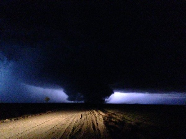
5 active tornado warnings right now in Texas and Kansas. A wedge is down and headed towards Dodge City.
 8
8

Posted on 11/16/15 at 6:19 pm to Scoop
I just got a flash flood watch notice on my telephone for here in MS tomorrow...it has been beautiful all day today, so there must be some pretty nasty shite headed this way...

Posted on 11/16/15 at 6:20 pm to Scoop
Thanks for the scoop scoop
Posted on 11/16/15 at 6:21 pm to Fusaichi Pegasus
Posted on 11/16/15 at 6:23 pm to TigerinOkieHell
Been watching the guy on the wedge. It's stable and is long track. Might be bad things for Dodge City.

Posted on 11/16/15 at 6:24 pm to Scoop


Posted on 11/16/15 at 6:24 pm to Scoop
Yeah this line of storms is gonna cover all of Louisiana
Posted on 11/16/15 at 6:25 pm to Scoop
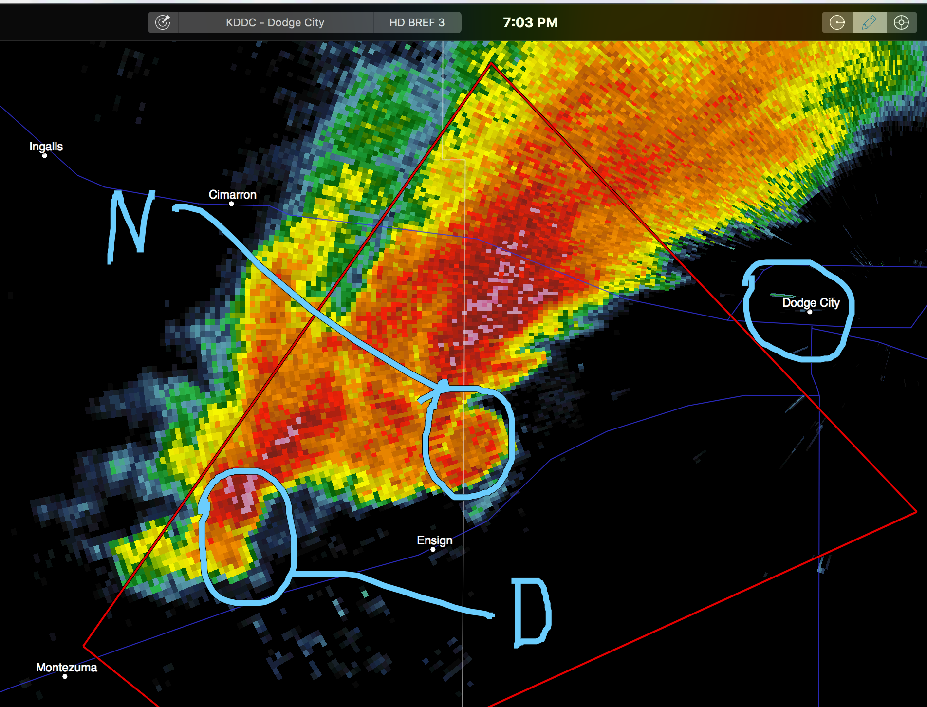
Yeah this storm is moving pretty fast too. Only about 30 minutes off from Dodge City. Looks really impressive on radar.
Edit: New warning north of Dodge City as well, another large tornado.
Edit: New warning north of Dodge City as well, another large tornado.
This post was edited on 11/16/15 at 6:27 pm
Posted on 11/16/15 at 6:29 pm to TigerinOkieHell
A guy on Live Chasing has been on he wedge since it's birth. It looked bad, then acted like it was gonna piss out after 5 minutes or so and then boom. It got ugly and is staying that way. This is a major tornado. Dodge City is in trouble.

Posted on 11/16/15 at 6:30 pm to The Cool No 9
quote:
Yeah this line of storms is gonna cover all of Louisiana
Yup...At a bad time as well...Between 1:30 a.m. and 5:30 a.m. wed morning...........
Posted on 11/16/15 at 6:54 pm to dukke v
quote:
Yup...At a bad time as well...Between 1:30 a.m. and 5:30 a.m. wed morning...........
So, Pj, what you're saying is 130 to 530 Wednesday morning should offer perfect weather for an outdoor party?

Posted on 11/16/15 at 6:55 pm to Scoop
And I just washed my car today

Posted on 11/16/15 at 6:56 pm to LSUsmartass
How is 1:30 and 5:30 am a bad time?? I'll be out cold thanks to melatonin and my white noise sound machine.
Posted on 11/16/15 at 6:57 pm to LSUsmartass
SEVERE WEATHER STATEMENT
NATIONAL WEATHER SERVICE DODGE CITY KS
649 PM CST MON NOV 16 2015
KSC051-135-195-170130-
/O.CON.KDDC.TO.W.0060.000000T0000Z-151117T0130Z/
TREGO KS-ELLIS KS-NESS KS-
649 PM CST MON NOV 16 2015
...A TORNADO WARNING REMAINS IN EFFECT UNTIL 730 PM CST FOR EASTERN
TREGO...NORTHWESTERN ELLIS AND NORTH CENTRAL NESS COUNTIES...
AT 640 PM CST...SPOTTERS CONFIRMED A TORNADO 2 MILES WEST OF
RANSOM...MOVING NORTHEAST AT 50 MPH.
HAZARD...DAMAGING TORNADO AND HALF DOLLAR SIZE HAIL.
SOURCE...RADAR CONFIRMED TORNADO.
IMPACT...FLYING DEBRIS WILL BE DANGEROUS TO THOSE CAUGHT WITHOUT
SHELTER. MOBILE HOMES WILL BE DAMAGED OR DESTROYED. DAMAGE
TO ROOFS...WINDOWS AND VEHICLES WILL OCCUR. TREE DAMAGE IS
LIKELY.
LOCATIONS IMPACTED INCLUDE...
ELLIS...OGALLAH...RIGA...YOCEMENTO AND CEDAR BLUFF.
Posted on 11/16/15 at 7:01 pm to Scoop
It appears that a historic type tornado outbreak is unfolding tonight.
Posted on 11/16/15 at 7:03 pm to rds dc
Dangerous situation near dodge city..
This post was edited on 11/16/15 at 7:07 pm
Posted on 11/16/15 at 7:05 pm to Mullet Flap
Posted on 11/16/15 at 7:05 pm to Mullet Flap
SEVERE WEATHER STATEMENT
NATIONAL WEATHER SERVICE AMARILLO TX
703 PM CST MON NOV 16 2015
OKC007-TXC295-357-170130-
/O.CON.KAMA.TO.W.0035.000000T0000Z-151117T0130Z/
BEAVER OK-LIPSCOMB TX-OCHILTREE TX-
703 PM CST MON NOV 16 2015
...A TORNADO WARNING REMAINS IN EFFECT UNTIL 730 PM CST FOR SOUTH
CENTRAL BEAVER...NORTHWESTERN LIPSCOMB AND NORTHEASTERN OCHILTREE
COUNTIES...
AT 703 PM CST...A CONFIRMED LARGE AND EXTREMELY DANGEROUS TORNADO WAS
LOCATED OVER BOOKER...OR 15 MILES NORTHEAST OF PERRYTON...MOVING
NORTHEAST AT 50 MPH.
THIS IS A PARTICULARLY DANGEROUS SITUATION.
HAZARD...DAMAGING TORNADO.
SOURCE...WEATHER SPOTTERS CONFIRMED TORNADO.
IMPACT...YOU ARE IN A LIFE THREATENING SITUATION. FLYING DEBRIS MAY
BE DEADLY TO THOSE CAUGHT WITHOUT SHELTER. MOBILE HOMES
WILL BE DESTROYED. CONSIDERABLE DAMAGE TO
HOMES...BUSINESSES AND VEHICLES IS LIKELY AND COMPLETE
DESTRUCTION IS POSSIBLE
.
LOCATIONS IMPACTED INCLUDE...
BOOKER...ELMWOOD AND BALKO.
PRECAUTIONARY/PREPAREDNESS ACTIONS...
A LARGE AND EXTREMELY DANGEROUS TORNADO IS ON THE GROUND
. TAKE
IMMEDIATE TORNADO PRECAUTIONS. THIS IS AN EMERGENCY SITUATION.
Posted on 11/16/15 at 7:08 pm to NorthEndZone
quote:
AT 703 PM CST...A CONFIRMED LARGE AND EXTREMELY DANGEROUS TORNADO WAS
LOCATED OVER BOOKER...OR 15 MILES NORTHEAST OF PERRYTON...MOVING
NORTHEAST AT 50 MPH.

This post was edited on 11/16/15 at 7:10 pm
Posted on 11/16/15 at 7:08 pm to NorthEndZone
ETA:
This post was edited on 11/16/15 at 7:10 pm

 Page 1 of 2

Popular
Back to top