- My Forums
- Tiger Rant
- LSU Recruiting
- SEC Rant
- Saints Talk
- Pelicans Talk
- More Sports Board
- Fantasy Sports
- Golf Board
- Soccer Board
- O-T Lounge
- Tech Board
- Home/Garden Board
- Outdoor Board
- Health/Fitness Board
- Movie/TV Board
- Book Board
- Music Board
- Political Talk
- Money Talk
- Fark Board
- Gaming Board
- Travel Board
- Food/Drink Board
- Ticket Exchange
- TD Help Board
Customize My Forums- View All Forums
- Show Left Links
- Topic Sort Options
- Trending Topics
- Recent Topics
- Active Topics
Started By
Message
re: Heads up for weather nuts.
Posted on 11/16/15 at 7:09 pm to Mullet Flap

Posted on 11/16/15 at 7:09 pm to Mullet Flap
Dodge City wedge lost it. Good thing. That was set up to be bad.
 1
1

Posted on 11/16/15 at 7:16 pm to Scoop
Yep! They're in the clear, thank goodness
Posted on 11/16/15 at 7:17 pm to Mullet Flap
quote:
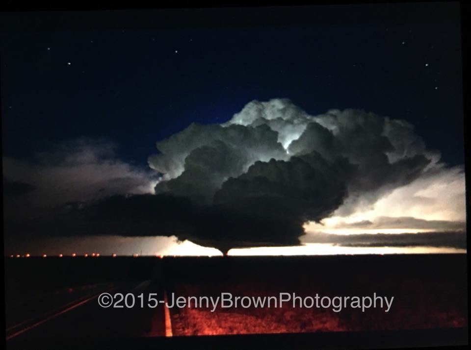
ETA:
That image shows the old meso occluding and new one forming, classic super cell cycling
Posted on 11/16/15 at 7:20 pm to rds dc
The guy that has been on the former wedge all this time just ran up on a semi turned over and blocking the road. He's pretty much blocked in and having to goat road now.

Posted on 11/16/15 at 7:24 pm to Paul Allen
quote:
How is 1:30 and 5:30 am a bad time??
That's when I'll be out on the road driving.
Posted on 11/16/15 at 7:30 pm to Scoop
Ajax headed in right behind it with blizzard conditions (supposedly) in Denver and all across the divide as well.

Posted on 11/16/15 at 7:41 pm to Dishmcds
I'm staying on the 15th floor of a hotel in downtown New Orleans tomorrow night, should I be nervous?
Posted on 11/16/15 at 7:57 pm to LSUsmartass
quote:
So, Pj, what you're saying is 130 to 530 Wednesday morning should offer perfect weather for an outdoor party?
That is when he is laying his LSU vs Ole Miss play...
For tomorrow:
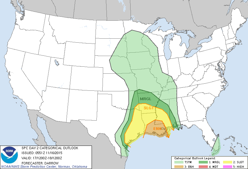
SEVERE STORMS WILL LIKELY DEVELOP AHEAD
OF THE LINE OF STORMS ACROSS PARTS OF LOUISIANA INTO CENTRAL AND
EASTERN ARKANSAS TO WESTERN MISSISSIPPI. SOME STRONG TORNADOES AND
DAMAGING WINDS WILL BE POSSIBLE TUESDAY AFTERNOON INTO THE EARLY
EVENING.
Posted on 11/16/15 at 8:25 pm to rds dc
It's bacon, I tell you, bacon.

Posted on 11/16/15 at 8:34 pm to Spankum
Where are you? It's been cloudy on the Coast and looking like it was going to rain.

Posted on 11/16/15 at 8:50 pm to MiloDanglers
quote:
I'm staying on the 15th floor of a hotel in downtown New Orleans tomorrow night, should I be nervous?
If you die in NO tomorrow night I guarantee it won't be from a tornado.
Posted on 11/16/15 at 10:48 pm to rds dc
DFW squall line in the early morning...

Posted on 11/16/15 at 11:07 pm to Scoop
So overblown
It won't get that bad in BR. Won't last long either.
It won't get that bad in BR. Won't last long either.
Posted on 11/16/15 at 11:18 pm to tigerbutt
It won't last long but ought to bring a good punch of wind with it. The concern is any cells that blow up in front of the line tomorrow. Atmosphere is primed to spin storms if they can manage to go up in the first place. Per the forecast discussions.
Posted on 11/17/15 at 5:43 am to Duke
Front doesn't appear to be moving fast anyway. Just some good energy generated. I guess everyone wants to get excited since we didn't have to deal with a hurricane again this year. That combined with dismal LSU football makes for a perfect storm when a few clouds roll in.

Posted on 11/17/15 at 1:25 pm to Scoop
It's coming right for us !


Posted on 11/17/15 at 1:34 pm to MorbidTheClown
The line on the radar right now does not look pretty. Gonna be a long night boys
Posted on 11/17/15 at 1:38 pm to CuseTiger
The line is going to be pretty intense but it's those cells on that model run posted above you around Livingston and Tangipahoa. Those cells could drop a tornado and some hail.

 Page 2 of 2


Popular
Back to top