- My Forums
- Tiger Rant
- LSU Recruiting
- SEC Rant
- Saints Talk
- Pelicans Talk
- More Sports Board
- Fantasy Sports
- Golf Board
- Soccer Board
- O-T Lounge
- Tech Board
- Home/Garden Board
- Outdoor Board
- Health/Fitness Board
- Movie/TV Board
- Book Board
- Music Board
- Political Talk
- Money Talk
- Fark Board
- Gaming Board
- Travel Board
- Food/Drink Board
- Ticket Exchange
- TD Help Board
Customize My Forums- View All Forums
- Show Left Links
- Topic Sort Options
- Trending Topics
- Recent Topics
- Active Topics
Started By
Message

 1
1


Posted on 5/13/24 at 11:55 am to Govt Tide
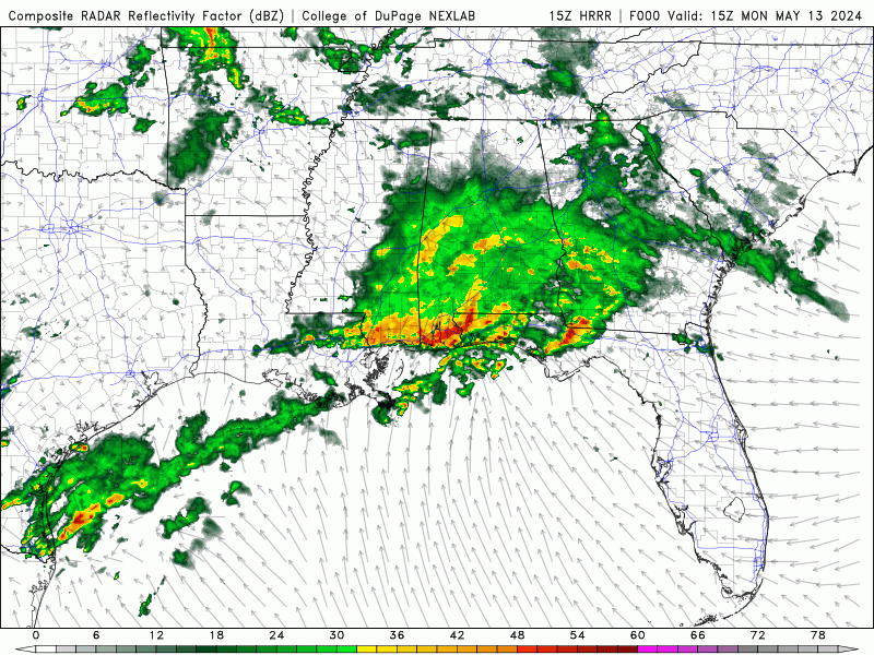
Pretty impressive line of storms between Destin and Panama City Beach right now.


Posted on 5/13/24 at 12:02 pm to Roll Tide Ravens
I am about to drive from Jackson's gap (Lake Martin) to Pensacola. Hoping by the time I get down there it will be manageable to drive through.
Posted on 5/13/24 at 12:09 pm to Bestbank Tiger
quote:
Got one or two downpours and a few loud claps of thunder.
You'll have another round this evening.
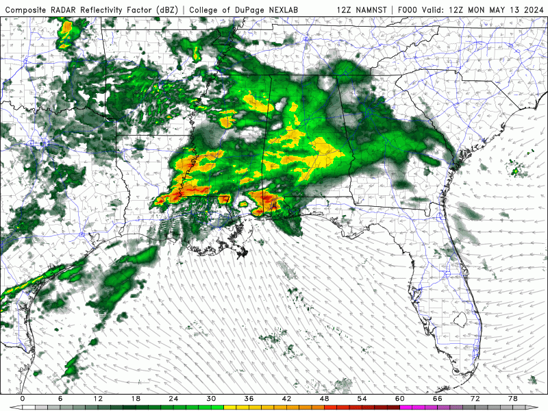
HRRR
NAM
Posted on 5/13/24 at 12:11 pm to Funky Tide 8
quote:
I am about to drive from Jackson's gap (Lake Martin) to Pensacola. Hoping by the time I get down there it will be manageable to drive through.
The worst of this wave is through Pensacola now, but as Legend mentioned above, there will probably be another round later today/tonight.
This post was edited on 5/13/24 at 12:12 pm
Posted on 5/13/24 at 12:15 pm to MasterAbe1
Went right over our house about 3:45. Rattled us out of bed. Some damage west of us and east of us. Got lucky here.
Posted on 5/13/24 at 12:16 pm to Roll Tide Ravens
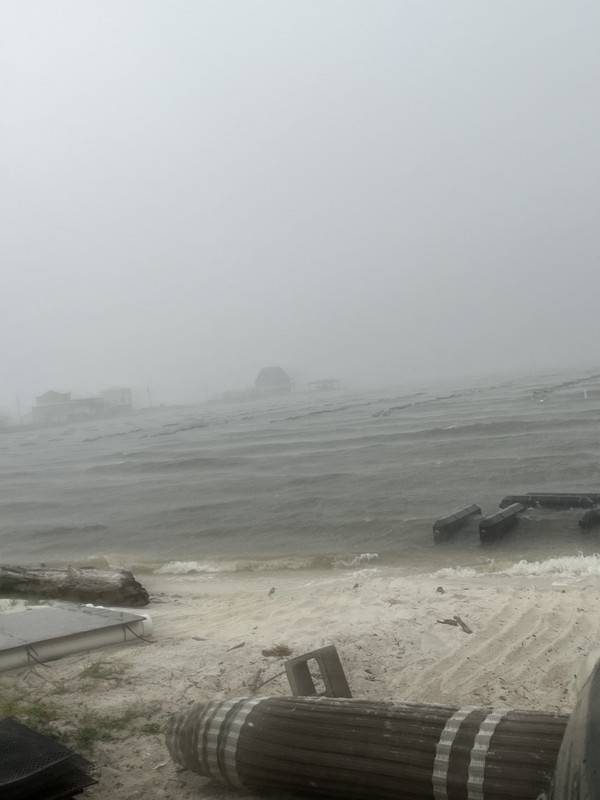
Wind changed quickly and temperature dropped from 81 to 64 in Ft Morgan.
This post was edited on 5/13/24 at 12:17 pm
Posted on 5/13/24 at 12:35 pm to LegendInMyMind
quote:
You'll have another round this evening.
Dang. We're gonna get clapped like the Fakers.

Posted on 5/13/24 at 12:51 pm to Bestbank Tiger
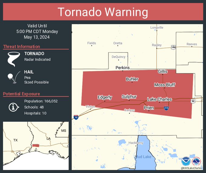
Automated call from Lake Charles school board. early dismissal at 2pm
Posted on 5/13/24 at 12:56 pm to LSURoss
Yep, Calcasieu parish school system is a joke with their weather shite.
Shannon will be canceling school for every rain drop until the end of the school year.
Shannon will be canceling school for every rain drop until the end of the school year.
Posted on 5/13/24 at 1:03 pm to LegendInMyMind
quote:
You'll have another round this evening.
Yeah. The hatched wind and hail area all the way down to the coast is a bit unusual. That is what I am watching.here near the coast.
quote:
Day 1 Convective Outlook
NWS Storm Prediction Center Norman OK
1128 AM CDT Mon May 13 2024
Valid 131630Z - 141200Z
...THERE IS AN ENHANCED RISK OF SEVERE THUNDERSTORMS THIS AFTERNOON
THROUGH TONIGHT FROM SOUTH CENTRAL TX TO SOUTHERN LA...AND ALONG THE
NORTHEAST GULF COAST...
...SUMMARY...
Severe thunderstorms are expected through tonight from south central
and southeast Texas across southern Louisiana, as well as the
Florida Panhandle. The potential exists for multiple corridors of
significant wind gusts, very large hail, and a few tornadoes.
...Northeast Gulf coast today...
An MCS with embedded bowing segments is ongoing across the western
FL Panhandle, with a history of measured severe gusts in the 54-71
kt range this morning. This convective system will likely persist
while moving east-southeastward through the afternoon, along and
immediately north of a surface warm front near the coast. Damaging
winds will be the main threat, though embedded circulations could
produce a couple of tornadoes.
...South central TX to southern LA through tonight...
A cluster of supercells formed this morning and is approaching areas
near and south of San Antonio as of 16z. Extreme buoyancy (MUCAPE
of 4000-6000 J/kg), steep midlevel lapse rates and strong deep-layer
vertical shear/long hodographs will favor very large hail near 3
inches in diameter as the primary threat through early afternoon.
Some upscale growth in this convection is likely through the
afternoon, as the storms spread generally eastward along a stalled
front across Houston and Lake Charles, with a continued large hail
threat and an increase in the potential for damaging winds of 60-80
mph. The storms could persist into the overnight hours while moving
across southern LA, along the outflow-reinforced boundary in the
wake of the ongoing storms over the FL Panhandle. Areas northeast
of this outflow boundary have been largely overturned into MS/AL,
with limited potential for destabilization prior to arrival of the
storms from the west.
...Northeast TX/northern LA to AR/MO through early tonight...
The primary midlevel trough will move eastward from KS/OK to MO/AR
through this evening. Lingering moisture/lapse rates to the north
of the Gulf coast convection will be sufficient for at least a
low-end hail/wind threat with convection this afternoon/evening
along/east of a weak cold front and in the zone of ascent preceding
the midlevel trough. The eastward extent of any severe threat
tonight will depend on recovery to the north of ongoing/expected
convection near the Gulf coast, which is low confidence.
..Thompson/Barnes.. 05/13/2024
Posted on 5/13/24 at 2:09 pm to NorthEndZone
forcast for Lake Charles seems to be pushing later and with less rain. At least according to weather Underground.

Posted on 5/13/24 at 4:24 pm to Bobby OG Johnson

Posted on 5/13/24 at 4:26 pm to Bobby OG Johnson
Posted on 5/13/24 at 4:30 pm to Bobby OG Johnson
Yep, nasty line of severe storms crossing into Louisiana.

Posted on 5/13/24 at 4:31 pm to Roll Tide Ravens
Got a good RIJ going with that one. Could put one down shortly.
Posted on 5/13/24 at 4:32 pm to Bobby OG Johnson

Posted on 5/13/24 at 4:36 pm to Bobby OG Johnson
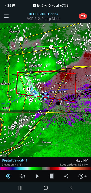
Posted on 5/13/24 at 4:37 pm to LegendInMyMind
quote:
Could put one down shortly
Posted on 5/13/24 at 4:38 pm to LSURoss
Tornado or not, that's rough.
The RIJ has sustained for a bit now. I wouldn't trust that storm from Northen LC up to Moss Bluff.
The RIJ has sustained for a bit now. I wouldn't trust that storm from Northen LC up to Moss Bluff.

 Page 2 of 26

Popular
Back to top