- My Forums
- Tiger Rant
- LSU Recruiting
- SEC Rant
- Saints Talk
- Pelicans Talk
- More Sports Board
- Fantasy Sports
- Golf Board
- Soccer Board
- O-T Lounge
- Tech Board
- Home/Garden Board
- Outdoor Board
- Health/Fitness Board
- Movie/TV Board
- Book Board
- Music Board
- Political Talk
- Money Talk
- Fark Board
- Gaming Board
- Travel Board
- Food/Drink Board
- Ticket Exchange
- TD Help Board
Customize My Forums- View All Forums
- Show Left Links
- Topic Sort Options
- Trending Topics
- Recent Topics
- Active Topics
Started By
Message
 2
2

Posted on 8/30/23 at 12:58 am to jfan244888
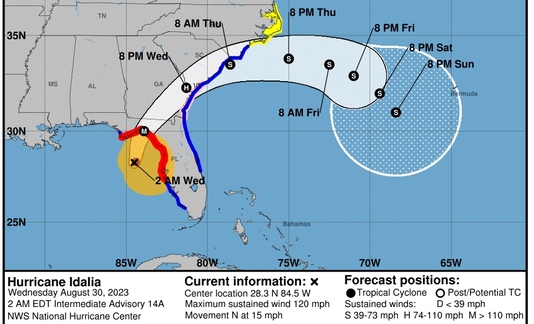
2:00 AM EDT Wed Aug 30
Location: 28.3°N 84.5°W
Moving: N at 15 mph
Min pressure: 945 mb
Max sustained: 120 mph
Officially a Cat 3. Still 5 or 6 hours from landfall.
Little wobble east as well. Midgrade Cat 4 on the table.
Location: 28.3°N 84.5°W
Moving: N at 15 mph
Min pressure: 945 mb
Max sustained: 120 mph
Officially a Cat 3. Still 5 or 6 hours from landfall.
Little wobble east as well. Midgrade Cat 4 on the table.
This post was edited on 8/30/23 at 1:01 am
Posted on 8/30/23 at 12:58 am to jfan244888
I see it moving @18 now. Big Bend landfall?
Posted on 8/30/23 at 1:03 am to sqerty
Going to be right at the top, near the Aucilla River. Tallahassee gonna get a pretty good blow on the backside. Might still be a hurricane when it hits the Atlantic (though not for long). SE GA getting in on the suck.
Posted on 8/30/23 at 1:03 am to sqerty
Yes
Posted on 8/30/23 at 1:13 am to Dlab2013
DISCUSSION AND OUTLOOK
----------------------
At 200 AM EDT (0600 UTC), the center of Hurricane Idalia was located
near latitude 28.3 North, longitude 84.5 West. Idalia is moving
toward the north near 15 mph (24 km/h). A northward to
north-northeastward motion is expected through morning, with
Idalia's center forecast to reach the Big Bend coast of Florida this
morning. After landfall, Idalia is forecast to turn toward the
northeast and east-northeast, moving near or along the coasts of
Georgia, South Carolina, and North Carolina late today and Thursday.
Hurricane Hunter aircraft data indicate that maximum sustained winds
have increased to near 120 mph (195 km/h) with higher gusts. Idalia
is a category 3 hurricane on the Saffir-Simpson Hurricane Scale.
Additional strengthening is forecast, and Idalia is forecast to
become a category 4 hurricane before it reaches the Big Bend coast
of Florida this morning. Idalia is likely to still be a hurricane
while moving across southern Georgia, and possibly when it reaches
the coast of Georgia or southern South Carolina late today.
Hurricane-force winds extend outward up to 25 miles (35 km) from the
center and tropical-storm-force winds extend outward up to 160 miles
(260 km). NOAA buoy 42036 recently reported sustained winds of 54
mph (87 km/h) and a gust to 69 mph (111 km/h) in the northern
rainbands of Idalia. Sarasota-Bradenton International Airport (KSRQ)
recently reported sustained winds of 35 mph (56 km/h) with a gust to
67 mph (108 km/h).
The estimated minimum central pressure based on Hurricane Hunter
aircraft observations is 945 mb (27.91 inches).
Posted on 8/30/23 at 1:26 am to sqerty

Posted on 8/30/23 at 1:53 am to NorthEndZone

Posted on 8/30/23 at 2:02 am to NorthEndZone
quote:
Hurricane Idalia Tropical Cyclone Update
NWS National Hurricane Center Miami FL AL102023
300 AM EDT Wed Aug 30 2023
...CATASTROPHIC STORM SURGE AND DESTRUCTIVE WINDS EXPECTED IN THE
FLORIDA BIG BEND REGION THIS MORNING WHEN IDALIA MOVES INLAND...
...3 AM POSITION UPDATE...
The estimated minimum pressure indicated by dropsonde data from an
Air Force Reserve Hurricane Hunter aircraft is 944 mb (27.88
inches).
NOAA buoy 42036 recently reported sustained winds of 63 mph (101
km/h) and a wind gust to 78 mph (126 km/h) in the western rainbands
of Idalia.
Several observing sites along the west coast of Florida have
reported tropical-storm force winds during the past hour.
SUMMARY OF 300 AM EDT...0700 UTC...INFORMATION
----------------------------------------------
LOCATION...28.5N 84.3W
ABOUT 90 MI...145 KM WSW OF CEDAR KEY FLORIDA
ABOUT 140 MI...225 KM S OF TALLAHASSEE FLORIDA
MAXIMUM SUSTAINED WINDS...120 MPH...195 KM/H
PRESENT MOVEMENT...N OR 10 DEGREES AT 15 MPH...24 KM/H
MINIMUM CENTRAL PRESSURE...944 MB...27.88 INCHES
$$
Forecaster D. Zelinsky
Posted on 8/30/23 at 2:03 am to NorthEndZone

Posted on 8/30/23 at 2:27 am to NorthEndZone

Posted on 8/30/23 at 3:13 am to Bobby OG Johnson

Posted on 8/30/23 at 3:21 am to Duke
For the 4AM EDT update: 941 mB, 125 mph
Posted on 8/30/23 at 3:26 am to Pepperoni
Officially a Cat 4

Posted on 8/30/23 at 4:20 am to joshnorris14
130 MPH (max sustained) at 5 AM (EDT) update. 940 mb.
Damned thing is flying (NNE @ 18 mph).
Damned thing is flying (NNE @ 18 mph).
This post was edited on 8/30/23 at 4:26 am
Posted on 8/30/23 at 4:22 am to udtiger
quote:
Damned thing is flying (NNE @ 18 mph).
This is a saving grace for those like me who are inland but still in its path. We're going to get hit with a lot of rain here in Augusta this afternoon. Thankfully it's moving fast so it won't be AS bad.
This post was edited on 8/30/23 at 4:23 am

Posted on 8/30/23 at 4:24 am to udtiger
Commie news network has the headline that it’s a cat 4???
Posted on 8/30/23 at 4:26 am to RollTide1987
quote:
This is a saving grace for those like me who are inland but still in its path. We're going to get hit with a lot of rain here in Augusta this afternoon. Thankfully it's moving fast so it won't be AS bad.
Good luck to you and everyone over there.
Posted on 8/30/23 at 4:30 am to berrycajun
quote:
Commie news network has the headline that it’s a cat 4???
Special Advisory at 4:20 AM EDT upgraded it to a Cat 4.

Posted on 8/30/23 at 4:44 am to joshnorris14
Am I wrong in thinking it a saving grace that its' hitting Florida where it is because of it being nearly all Wildlife Refuge's?
Not much in the way of population on that area of the coast.
Not much in the way of population on that area of the coast.

 Page 118 of 139

Popular
Back to top