- My Forums
- Tiger Rant
- LSU Recruiting
- SEC Rant
- Saints Talk
- Pelicans Talk
- More Sports Board
- Fantasy Sports
- Golf Board
- Soccer Board
- O-T Lounge
- Tech Board
- Home/Garden Board
- Outdoor Board
- Health/Fitness Board
- Movie/TV Board
- Book Board
- Music Board
- Political Talk
- Money Talk
- Fark Board
- Gaming Board
- Travel Board
- Food/Drink Board
- Ticket Exchange
- TD Help Board
Customize My Forums- View All Forums
- Show Left Links
- Topic Sort Options
- Trending Topics
- Recent Topics
- Active Topics
Started By
Message
re: Just bought Lowrance Hook 7-Question about the maps(paging WHODAT)
Posted on 3/10/17 at 11:02 am to lsupride87
Posted on 3/10/17 at 11:02 am to lsupride87
Whodat and myself make maps. I'll text him that you are looking for him. Our maps will work on your unit. It will be a Google Earth image overlay.
 1
1

Posted on 3/10/17 at 11:03 am to Janky
Our maps won't work with Garmin or humming bird

Posted on 3/10/17 at 11:04 am to lsupride87
quote:It does?
Ahh. Thanks for your help. Makes sense now

Posted on 3/10/17 at 11:06 am to SeaPickle
quote:Nice. Still able to mark points correct?
Our maps will work on your unit. It will be a Google Earth image overlay.
Posted on 3/10/17 at 11:23 am to lsupride87
Yes all way points and routes will show. It's a photo overlay. Everything will show on top of the map
Posted on 3/10/17 at 11:28 am to SeaPickle
Perfect. What do y'all charge? A case of bud light? 

Posted on 3/10/17 at 11:29 am to lsupride87
Well it's not a joint thing. He makes his and I make mine and sell separately so I can't give his price. I did let him know you were looking for him
This post was edited on 3/10/17 at 11:33 am

Posted on 3/10/17 at 11:34 am to SeaPickle
I'm surprised he wasn't in here already, usually "lowrance" is like a bat signal for whodat.
Posted on 3/10/17 at 11:44 am to DownSouthDave
If I had the TDC market I'd be like that too
LSUPRIDE here is a picture of my gps showing last island with way points and trails. The polarized screen made the black lines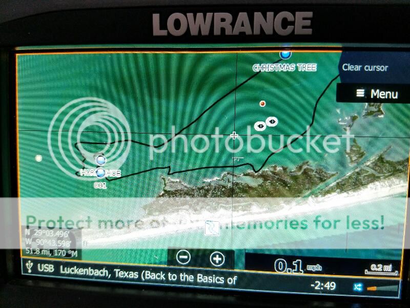
LSUPRIDE here is a picture of my gps showing last island with way points and trails. The polarized screen made the black lines
This post was edited on 3/10/17 at 11:44 am
Posted on 3/10/17 at 11:44 am to SeaPickle
That's good stuff
I'm a little pissed for $500 the unit doesn't come with a map worth a shite......
I'm a little pissed for $500 the unit doesn't come with a map worth a shite......
Posted on 3/10/17 at 11:49 am to DownSouthDave
Hey yea I have the maps that cover all of south la and can make them for anywhere. Shoot me an email at whodat51486@gmail.com
Seapickle and I just need to go into business together lol
Seapickle and I just need to go into business together lol
This post was edited on 3/10/17 at 11:52 am
Posted on 3/10/17 at 11:51 am to lsupride87
If it makes you feel better the maps in my $1400 unit still suck
This post was edited on 3/10/17 at 11:57 am
Posted on 3/10/17 at 11:52 am to SeaPickle
Exactly the hds units maps are just as shitty as the cheaper units
Posted on 3/16/19 at 12:01 pm to WHODAT514
You guys still making maps?

Posted on 3/16/19 at 7:31 pm to pineveillj
Good thread on here about making your own maps. Prob either page 1 or 2. That’s the way to go if you have access to a pc.
Been doing it for a couple years now, really easy and end product comes out nice.
Been doing it for a couple years now, really easy and end product comes out nice.
Posted on 3/16/19 at 7:38 pm to SeaPickle
I need to follow someone this summer out to last island. Never been as I did most of my fishing in fresh water. Now that I have a boat to make it out there I need to track the way on my GPS!

Posted on 3/16/19 at 8:28 pm to lsupride87
Hopefully it’s a hook and not a hook2. The hook2’s are shite and do not take satellite image cards.
Posted on 3/16/19 at 8:42 pm to lsupride87
I like the navionics maps more than satellite overlay.
Posted on 3/16/19 at 9:00 pm to DownshiftAndFloorIt
Nawh we no longer make these, we have info in the new thread on how to make em yourself
Posted on 3/16/19 at 9:11 pm to DownshiftAndFloorIt
Navionics are definitely the way to go for lakes but is no use for the marsh which is why all south la wants the satellite imagery.

 Page 2 of 3

Popular
Back to top