- My Forums
- Tiger Rant
- LSU Recruiting
- SEC Rant
- Saints Talk
- Pelicans Talk
- More Sports Board
- Fantasy Sports
- Golf Board
- Soccer Board
- O-T Lounge
- Tech Board
- Home/Garden Board
- Outdoor Board
- Health/Fitness Board
- Movie/TV Board
- Book Board
- Music Board
- Political Talk
- Money Talk
- Fark Board
- Gaming Board
- Travel Board
- Food/Drink Board
- Ticket Exchange
- TD Help Board
Customize My Forums- View All Forums
- Show Left Links
- Topic Sort Options
- Trending Topics
- Recent Topics
- Active Topics
Started By
Message
re: Wednesday weather thread: MS, AL, LA, TN, Enhanced for MS, AL, TN
Posted on 12/28/21 at 2:54 pm to geauxtigers87
Posted on 12/28/21 at 2:54 pm to geauxtigers87
quote:
Feels like Temps 20s for the southshore Monday morning, 60s on Tuesday. What the frick is happening
Setting up for another, possibly high end, severe threat Friday/Saturday.
Something needs to break that fricking ridge in the Gulf and sweep out those mid 70s dews. Unfortunately, tomorrow's nor the next trough looks like it will do that longterm. In a couple days we're back to 60s/70s and looking for the next severe setup.
 0
0

Posted on 12/28/21 at 3:18 pm to East Coast Band
This is some weird weather and I don't believe global warming is at play.

Posted on 12/28/21 at 3:54 pm to East Coast Band
Can Western Kentucky catch a break for a while? Last weather thread I thought I was saying goodbye.
It’s gonna be 66 tomorrow here. 69 degrees on New Years Eve. Usually it’s freezing cold that day. Gonna be alot of people out that night.
It’s gonna be 66 tomorrow here. 69 degrees on New Years Eve. Usually it’s freezing cold that day. Gonna be alot of people out that night.

Posted on 12/28/21 at 3:57 pm to East Coast Band
Saturday is looking like a potential issue, too, but need to get through this one first.
Posted on 12/29/21 at 12:12 am to Roll Tide Ravens
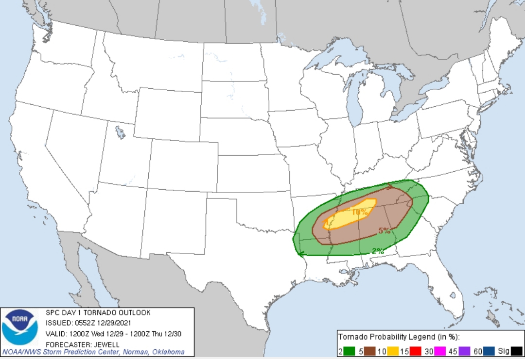
SPC upgrades tomorrow (Wednesday) to an Enhanced Risk for parts of AR,MS,AL, and TN. Slight risk also expanded.
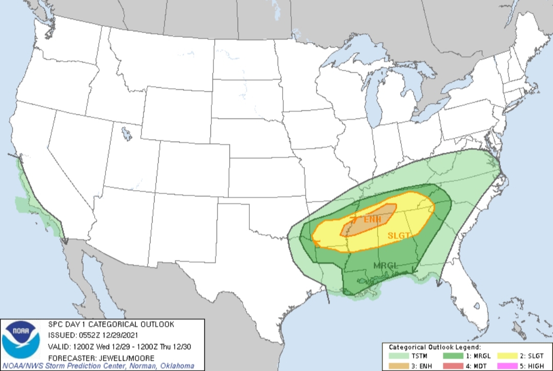
quote:
Day 1 Convective Outlook NWS Storm Prediction Center Norman OK 1152 PM CST Tue Dec 28 2021
Valid 291200Z - 301200Z
...THERE IS AN ENHANCED RISK OF SEVERE THUNDERSTORMS FROM EASTERN ARKANSAS INTO PARTS OF NORTHERN MISSISSIPPI AND ALABAMA AND INTO SOUTHERN TENNESSEE...
...SUMMARY... Severe thunderstorms are forecast from parts of the lower Mississippi Valley into the Tennessee Valley. Damaging wind gusts, a few tornadoes, and hail are possible during the afternoon and evening.
...Synopsis... An expansive area of strong southwest flow aloft will stretch from Mexico into the Northeast, with a low-amplitude shortwave trough over the central Plains during the day. This wave will cross the MS River during the evening, with the bulk of the height falls north of the OH River. However, 60-70 kt midlevel wind speeds will exist as far south as the TN Valley.
At the surface, low pressure will develop near the ArkLaTex, with a trough extending eastward into TN and KY during the evening. A front will remain nearly stationary, from central AR into northern TN. Southwesterly low-level winds will maintain mid to upper 60s F dewpoints south of this boundary, with 70s F across LA, southern MS and AL. Southwest 850 mb winds will increase to 40 kt, enhancing lift from warm advection during the afternoon and evening across MS, AL and TN. A dryline will also extend from the ArkLaTex southwestward toward I-35 in TX, moving slowly east during the evening.
...Lower MS Valley into the TN Valley... Storms are expected to initiate during the afternoon from southern AR into northern MS related to the warm advection regime. SRH is forecast to increase to around 200 m2/s2, with effective deep-layer shear up to 60 kt. This will favor supercells moving east/northeast, and a few tornadoes will be possible. Long hodographs may also favor hail. Convection is expected to increase in coverage as it interacts with the stationary front, with mixed storm modes possibly developing with damaging winds also possible. The severe risk may extend east toward the southern Appalachians as the veered 850 mb winds aid moisture advection. While instability will be weaker farther east into GA and the western Carolinas, strong shear may yield an isolated tornado or damaging gusts.
Elsewhere, it is more uncertain how much convection will occur across the warm sector including much of AL and western GA, but any areas of storms that can develop there overnight could pose a severe risk.
..Jewell/Moore.. 12/29/2021
CLICK TO GET WUUS01 PTSDY1 PRODUCT
NOTE: THE NEXT DAY 1 OUTLOOK IS SCHEDULED BY 1300Z
This post was edited on 12/29/21 at 12:13 am
Posted on 12/29/21 at 12:20 am to LegendInMyMind
This is still a bit of a contingent threat with a couple possible failure modes. One of which is ongoing storms that could hamper the instability across at least part of the Enhanched Risk area.
There's plenty enough energy with the high temps and dews. CAMs are struggling really with the ability for storms to start spinning. There is almost an even split between them in that regard.
There's plenty enough energy with the high temps and dews. CAMs are struggling really with the ability for storms to start spinning. There is almost an even split between them in that regard.
Posted on 12/29/21 at 1:50 am to LegendInMyMind
Great, the enhanced area is basically a circle drawn around me 
Posted on 12/29/21 at 6:11 am to East Coast Band
Updating title.
Posted on 12/29/21 at 10:41 am to East Coast Band
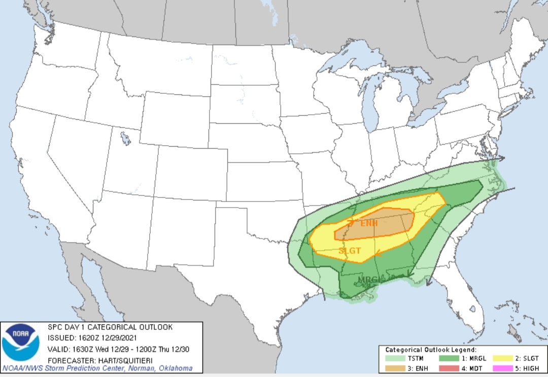
The enhanced risk has now been expanded eastward a bit, and a hatched area has been added to the 10% tornado probabilities:


Posted on 12/29/21 at 10:43 am to East Coast Band
Enhanced Risk area has been expanded to cover pretty much all of North AL and North MS.
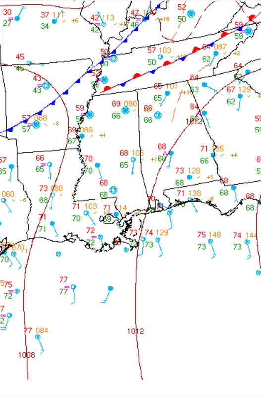
Tracking the 70s temps and higher dews as they make their way North throughout the day. North AL is pretty much socked in with cloud cover right now, but the clearing should happen SW to NE ahead of this afternoon. Farther South we already have low 70s over high 60s.
We had some storms last night with heavy rain and some wind. I expect those to have laid down some boundaries where we may see some severe storms form this afternoon/evening.
This post was edited on 12/29/21 at 10:45 am
Posted on 12/29/21 at 10:50 am to LegendInMyMind
quote:
We had some storms last night with heavy rain and some wind. I expect those to have laid down some boundaries where we may see some severe storms form this afternoon/evening.
Yeah, I've already seen some mets talking about that, particularly with the convection that is currently over NE MS and NW AL. There might be a corridor somewhere along in there with an enhanced tornado potential, which I think we are seeing with where SPC placed the hatched area.
Posted on 12/29/21 at 10:53 am to Roll Tide Ravens
Tors love surface boundaries, like lets say the outflow boundary left behind by morning convection.
Posted on 12/29/21 at 10:56 am to Roll Tide Ravens
The LLJ looks stronger now than it has at any other time leading up to today. It ramps up over the area at around 6pm. By that time we will have the temps/dews in place along with those pockets of bigger CAPE. There doesn't look like there will be a lack of shear.
This evening may overachieve what most were thinking even yesterday at this time.
I'm hoping these clouds and light rain can hang around most of the day.
Reed is live from N MS right now. I'm sure there are plenty of other chasers out and about.
This evening may overachieve what most were thinking even yesterday at this time.
I'm hoping these clouds and light rain can hang around most of the day.
Reed is live from N MS right now. I'm sure there are plenty of other chasers out and about.
Posted on 12/29/21 at 10:57 am to Duke
quote:
Tors love surface boundaries, like lets say the outflow boundary left behind by morning convection.
Let's say they don't like them just for today, deal?

Posted on 12/29/21 at 10:58 am to LegendInMyMind
Looks like an even more significant shot of cold air than this coming weekend is on the table for the weekend after that.
Posted on 12/29/21 at 11:00 am to Duke
Y'all can check out the wX app if you want an app that combines alot of stuff that normally takes multiple websites. It is called just wX and is on iOS and Android.
It will be particularly helpful with MCD discussions during an event because it has a share option that automatically shares the discussion you're looking at. It has all active warnings/discussions live. It beats even following NWS offices on Twitter.
It will be particularly helpful with MCD discussions during an event because it has a share option that automatically shares the discussion you're looking at. It has all active warnings/discussions live. It beats even following NWS offices on Twitter.
This post was edited on 12/29/21 at 11:03 am
Posted on 12/29/21 at 11:01 am to The Boat
quote:
Looks like an even more significant shot of cold air than this coming weekend is on the table for the weekend after that.
Yep. With a Slight already on the board for the same area on Friday. That will probably be an overnight event for my area.
This post was edited on 12/29/21 at 11:08 am
Posted on 12/29/21 at 11:06 am to LegendInMyMind
As I have looked at this, I feel Northern MS and NW Alabama is the target zone today. Gotta watch the small scale features at this point such as any boundary lines from some of the early rain and such but hopefully some of the trigger mechanisms don't come together. That's my hope for this system today. My gut tells me it's not going to be THAT bad but we shall see.
Posted on 12/29/21 at 11:24 am to Crimson1st
Following those observations from earlier, it is 78°/69° in Laurel, MS right now and 64°/62° in Decatur, AL.
That's the difference the clouds and rain is making at the moment.
That's the difference the clouds and rain is making at the moment.
Posted on 12/29/21 at 12:08 pm to LegendInMyMind
This area, outside of the Enhanced Risk area, is looking concerning.
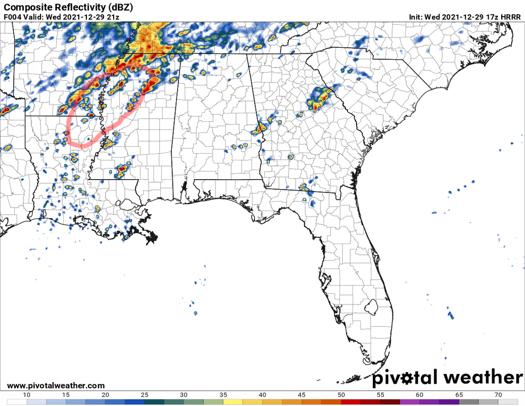
The Northern mode starts to get messier from that point on with the SW trailing edge of the system over the Arklamiss to the NE being in the clear and co-located with 3,000 SB CAPE and good Bulk Shear. Those storms could also be on or near a boundary laid down by morning convection. Anything discrete there will likely be a problem.
You can see that area starting to clear out some:
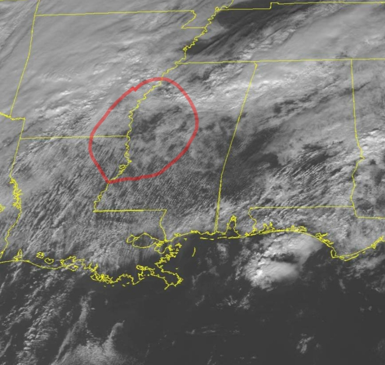
With no rain in the past few hours and winds picking up out of the SSW at around 20mph+ at the Greenville obs site.
The Northern mode starts to get messier from that point on with the SW trailing edge of the system over the Arklamiss to the NE being in the clear and co-located with 3,000 SB CAPE and good Bulk Shear. Those storms could also be on or near a boundary laid down by morning convection. Anything discrete there will likely be a problem.
You can see that area starting to clear out some:
With no rain in the past few hours and winds picking up out of the SSW at around 20mph+ at the Greenville obs site.
This post was edited on 12/29/21 at 12:22 pm

 Page 2 of 7

Popular
Back to top