




- My Forums
- Tiger Rant
- LSU Recruiting
- SEC Rant
- Saints Talk
- Pelicans Talk
- More Sports Board
- Fantasy Sports
- Golf Board
- Soccer Board
- O-T Lounge
- Tech Board
- Home/Garden Board
- Outdoor Board
- Health/Fitness Board
- Movie/TV Board
- Book Board
- Music Board
- Political Talk
- Money Talk
- Fark Board
- Gaming Board
- Travel Board
- Food/Drink Board
- Ticket Exchange
- TD Help Board
Customize My Forums- View All Forums
- Show Left Links
- Topic Sort Options
- Trending Topics
- Recent Topics
- Active Topics
Started By
Message
re: Weather Board: Enhanced (3 out of 5) Risk for Yankees This PM. Tornado Watch For Masters
Posted on 4/13/19 at 4:52 pm to rt3

Posted on 4/13/19 at 4:52 pm to rt3

Looks like flow is converging in the circled area. Near where the PDS tornado got spinning up. I suspect this is the general area to see bigger tornadoes over the next couple of hours.
Let's hope I'm wrong.
Haha. The SPC just shared their thoughts. And uh, I fouled it off but made contact.

quote:
SUMMARY...The tornado threat will be maximized across eastern Louisiana and portions of southwest Mississippi along the I-20 corridor over the next 1 to 2 hours. DISCUSSION...21Z surface analysis shows a warm front along the I-20 corridor from Vicksburg to Jackson, MS. Along and south of this boundary is where the tornado threat will be maximized over the next 1 to 2 hours. Very strong (30 to 35 knot) sustained southeasterly surface winds are present across most surface observing stations south of this warm front. The DGX VWP shows these winds veering and strengthening to around 50 knots around 1.5 to 2 km above the surface which yields 0-1 SRH around 250 to 300 m2/s2. A line-embedded supercell currently moving into Mississippi in southwest Warren county has taken advantage of this streamwise vorticity rich environment with a consistent 50 to 60 knot Vrot over the last 15 to 20 minutes from the KDGX WSR-88D. This storm, and any additional strong updrafts which can develop in this area within the next 1 to 2 hours have the potential to produce significant tornadoes given the low level thermodynamic and kinematic environment.
This post was edited on 4/13/19 at 4:54 pm
 4
4


Posted on 4/13/19 at 4:53 pm to SEClint
speaking of the Masters... going to groupings of 3 tomorrow teeing off at both the 1st & 10th holes starting at 7:30 AM


Posted on 4/13/19 at 4:54 pm to Scoop
quote:
NWLa is officially in the clear. That was so weak. The worst of it was at 6 AM. Not a single tornado in NWLa this afternoon. No winds, no hail, no tornados.
And that’s bad? Why can’t people just be happy that it didn’t turn out as bad as it could have been?
Be thankful you aren’t like the people who did see damage today.


Posted on 4/13/19 at 4:56 pm to Duke
quote:can you catch? We seriously need a catcher
I fouled it off but made contact.
Posted on 4/13/19 at 4:58 pm to ForeverLSU02
quote:
can you catch? We seriously need a catcher
I caught in little league... some 20-25 years ago
Posted on 4/13/19 at 4:58 pm to ForeverLSU02
Anyone have the path of the tensas tornado near newlight?
Made my parents leave from there yesterday.
Made my parents leave from there yesterday.
Posted on 4/13/19 at 4:59 pm to rt3
Rough day here in Oak Ridge. Hail before dawn, really heavy north of town. Trees and power lines down south of town....roads closed, etc. Rough cell ripped through around noon and took down some more trees. Tornado on ground near Lake Lafourche mid afternoon. Ive been on edge since around 530am.....just waiting for the next punch from Mother Nature. The hail probably did the most damage.......the young corn doesn’t like quarter sized hail. Hopefully the worst has passed.....but I am worried about that skinny line that looks like a whip coming from SWLA.
Posted on 4/13/19 at 4:59 pm to rt3
(no message)
This post was edited on 4/20/19 at 7:36 am
Posted on 4/13/19 at 5:00 pm to rt3
quote:that'll do
I caught in little league... some 20-25 years ago

Posted on 4/13/19 at 5:01 pm to Duke
Is Monroe mostly out of the danger zone now? It was a little dicey here for about 2 hours. Seemed mostly slow rain now, looks like we are in the middle of the line now too. Looking for some professional opinions.

Posted on 4/13/19 at 5:01 pm to Duke
To be honest, I think the worst of this event will come for MS and AL. That’s where the best chance of discrete supercells will likely be. I think parts of MS and AL could see some strong, long-track tornadoes.
This post was edited on 4/13/19 at 5:03 pm
Posted on 4/13/19 at 5:01 pm to teatiger
quote:Scoop is erect
Rough day here in Oak Ridge. Hail before dawn, really heavy north of town. Trees and power lines down south of town....roads closed, etc. Rough cell ripped through around noon and took down some more trees. Tornado on ground near Lake Lafourche mid afternoon. Ive been on edge since around 530am.....just waiting for the next punch from Mother Nature. The hail probably did the most damage
Posted on 4/13/19 at 5:04 pm to Coatesbathroom
quote:
Is Monroe mostly out of the danger zone now? It was a little dicey here for about 2 hours. Seemed mostly slow rain now, looks like we are in the middle of the line now too.
The SPC highlighted the biggest threat to your south.
Posted on 4/13/19 at 5:05 pm to Roll Tide Ravens
quote:
I think the worst of this event will come for MS and AL. That’s where the best chance of discrete supercells will likely be.
I'm thinking the risk is for southern Mississippi more than Alabama as they'll have the daytime heating to help and more proximity to the low.
But you know, you'll never go broke betting on some severe weather in the northern half of Alabama.
Posted on 4/13/19 at 5:07 pm to Duke
rumbles of thunder starting here again
and round 2... here we go
and round 2... here we go
Posted on 4/13/19 at 5:13 pm to rt3
and we get to do this all again on Wednesday night/Thursday morning

Posted on 4/13/19 at 5:16 pm to Duke
That’s exactly where Jeff is currently

This post was edited on 4/13/19 at 5:19 pm
Posted on 4/13/19 at 5:18 pm to Ba Ba Boooey
TWC just said most of Vicksburg is without power
Posted on 4/13/19 at 5:20 pm to rt3
round 2 is officially on for CenLA
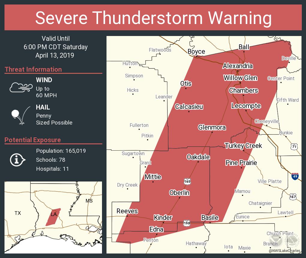
Posted on 4/13/19 at 5:21 pm to rt3
RT, you’re a Cenla baw right? Is it ill advised to try and get a quick dinner in? I’d hate to be at Mi Tierra and the power go out.
Eta: nevermind, I see the post above.
Eta: nevermind, I see the post above.
This post was edited on 4/13/19 at 5:22 pm

 Page 33 of 47

Popular
Back to top
 Follow TigerDroppings for LSU Football News