




- My Forums
- Tiger Rant
- LSU Recruiting
- SEC Rant
- Saints Talk
- Pelicans Talk
- More Sports Board
- Fantasy Sports
- Golf Board
- Soccer Board
- O-T Lounge
- Tech Board
- Home/Garden Board
- Outdoor Board
- Health/Fitness Board
- Movie/TV Board
- Book Board
- Music Board
- Political Talk
- Money Talk
- Fark Board
- Gaming Board
- Travel Board
- Food/Drink Board
- Ticket Exchange
- TD Help Board
Customize My Forums- View All Forums
- Show Left Links
- Topic Sort Options
- Trending Topics
- Recent Topics
- Active Topics
Started By
Message

 1
1


Posted on 4/13/19 at 2:30 pm to rt3
Well we're in our downstairs hall bath. Feels like we live in Arkansas again. 

Posted on 4/13/19 at 2:35 pm to Duke
Rain has moved out. If it warms up pretty quickly over the next 2 hours could get interesting over here. Still too cold for anything real bad to occur


Posted on 4/13/19 at 2:38 pm to deltaland
I’m on Toledo bend off of 191.
Firing up the grill preparing to get rocked by this storm.
Firing up the grill preparing to get rocked by this storm.
Posted on 4/13/19 at 2:40 pm to McCaigBro69
looks like the worst of that cell is now to my north and pulling away
but there could be an inflow notch trying to develop on it now as it heads towards Pollock and then to Jena
but there could be an inflow notch trying to develop on it now as it heads towards Pollock and then to Jena

Posted on 4/13/19 at 2:40 pm to Scoop
I’m feeling pretty good about NWLa. There is a gap between the line coming out of Texas and the crowded stuff in NELa. There have been distinct cells trying to develop in the gap and they are not getting there.
Posted on 4/13/19 at 2:41 pm to rt3
the tornado warning for Alexandria/Pineville/Ball has been dropped


Posted on 4/13/19 at 2:42 pm to McCaigBro69
I have to drive from BR to Monroe due to a death in the family and have to leave today. I can leave in an hour or wait until about eight tonight. Any weather baws wanna give me advice? TIA
This post was edited on 4/13/19 at 2:55 pm
Posted on 4/13/19 at 2:42 pm to rt3
guys... this is a historic day
for the 1st time in my life... I can say I heard a tornado siren blaring during an active tornado warning
for the 1st time in my life... I can say I heard a tornado siren blaring during an active tornado warning
Posted on 4/13/19 at 2:44 pm to Remo Williams
Which way are you heading? Although, I don’t think it’s very safe to leave Monroe heading in any direction in an hour or at 8..

Posted on 4/13/19 at 2:47 pm to lsuman25
Looks like its night time pretty much just a little southwest of Monroe
Posted on 4/13/19 at 2:49 pm to BayouBengals18
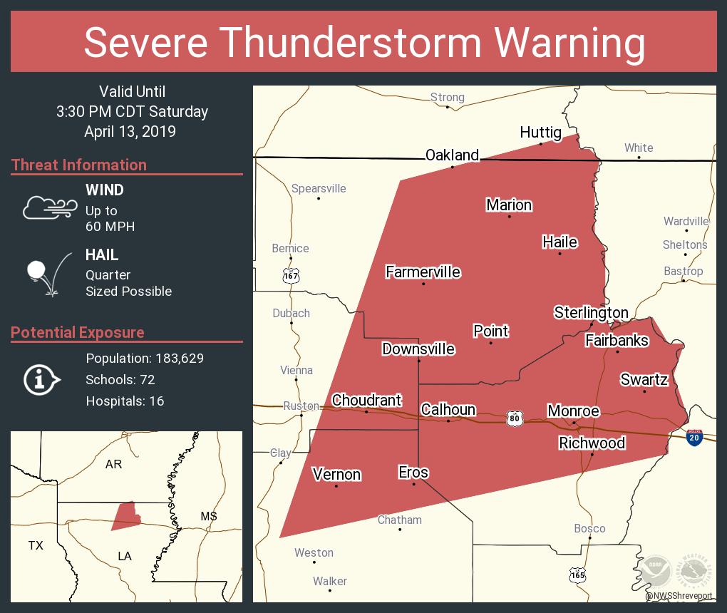
Posted on 4/13/19 at 2:50 pm to rds dc
Is there a map with pin drops where all the tornadoes have touched down? Or been spotted?
Posted on 4/13/19 at 2:50 pm to TigerChief10
A lot of jackassery goes on here but threads like this are the OT at its best 
Posted on 4/13/19 at 2:50 pm to BayouBengals18
61 to I-20 to Monroe.


Posted on 4/13/19 at 2:51 pm to Remo Williams
Looks like things have calmed down for the moment.

Posted on 4/13/19 at 2:52 pm to rt3
Houston area: new severe thunderstorm warning for Cinco ranch area NE towards jersey village.
quote:
.A SEVERE THUNDERSTORM WARNING REMAINS IN EFFECT UNTIL 315 PM CDT
FOR NORTH CENTRAL FORT BEND AND NORTHWESTERN HARRIS COUNTIES...
At 246 PM CDT, a severe thunderstorm was located over Pecan Grove,
moving northeast at 55 mph.
HAZARD...Ping pong ball size hail and 60 mph wind gusts.
SOURCE...Radar indicated.
IMPACT...People and animals outdoors will be injured. Expect hail
damage to roofs, siding, windows, and vehicles. Expect wind
damage to roofs, siding, and trees.
Locations impacted include...
Northern Rosenberg, Richmond, Jersey Village, Bunker Hill Village,
Pecan Grove, Spring Branch North, Eldridge / West Oaks, Spring Branch
West, Addicks Park Ten, Mission Bend, Hedwig Village, Spring Branch
Central, Cinco Ranch, Langwood, Fairbanks / Northwest Crossing,
Willowbrook, Westbranch, Briar Forest, Greater Inwood and Carverdale.
This post was edited on 4/13/19 at 2:54 pm
Posted on 4/13/19 at 2:53 pm to LSUJuice
Keep an eye on that cell just north of Krotz Springs
Posted on 4/13/19 at 2:54 pm to Remo Williams

Posted on 4/13/19 at 2:56 pm to rt3
quote:
NWS Lake Charles @NWSLakeCharles
250 PM Radar Update for Tornado Watch 53. Now monitoring development over SE Texas. #txwx #lawx

 Page 29 of 47

Popular
Back to top
 Follow TigerDroppings for LSU Football News