- My Forums
- Tiger Rant
- LSU Recruiting
- SEC Rant
- Saints Talk
- Pelicans Talk
- More Sports Board
- Coaching Changes
- Fantasy Sports
- Golf Board
- Soccer Board
- O-T Lounge
- Tech Board
- Home/Garden Board
- Outdoor Board
- Health/Fitness Board
- Movie/TV Board
- Book Board
- Music Board
- Political Talk
- Money Talk
- Fark Board
- Gaming Board
- Travel Board
- Food/Drink Board
- Ticket Exchange
- TD Help Board
Customize My Forums- View All Forums
- Show Left Links
- Topic Sort Options
- Trending Topics
- Recent Topics
- Active Topics
Started By
Message
re: UPDATE: Another Potential Severe Weather Event for the South (insert dates)
Posted on 3/27/21 at 8:00 pm to LegendInMyMind
Posted on 3/27/21 at 8:00 pm to LegendInMyMind
How bout collierville tn?
 2
2


Posted on 3/27/21 at 8:00 pm to Bobby OG Johnson
That storm near Pine Bluff looks pretty bad.
Posted on 3/27/21 at 8:01 pm to Roll Tide Ravens
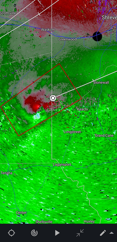
The storm southwest of Shreveport also has pretty strong rotation.
ETA: large and extremely dangerous tornado on that one
ETA: large and extremely dangerous tornado on that one
This post was edited on 3/27/21 at 8:02 pm
Posted on 3/27/21 at 8:03 pm to LegendInMyMind
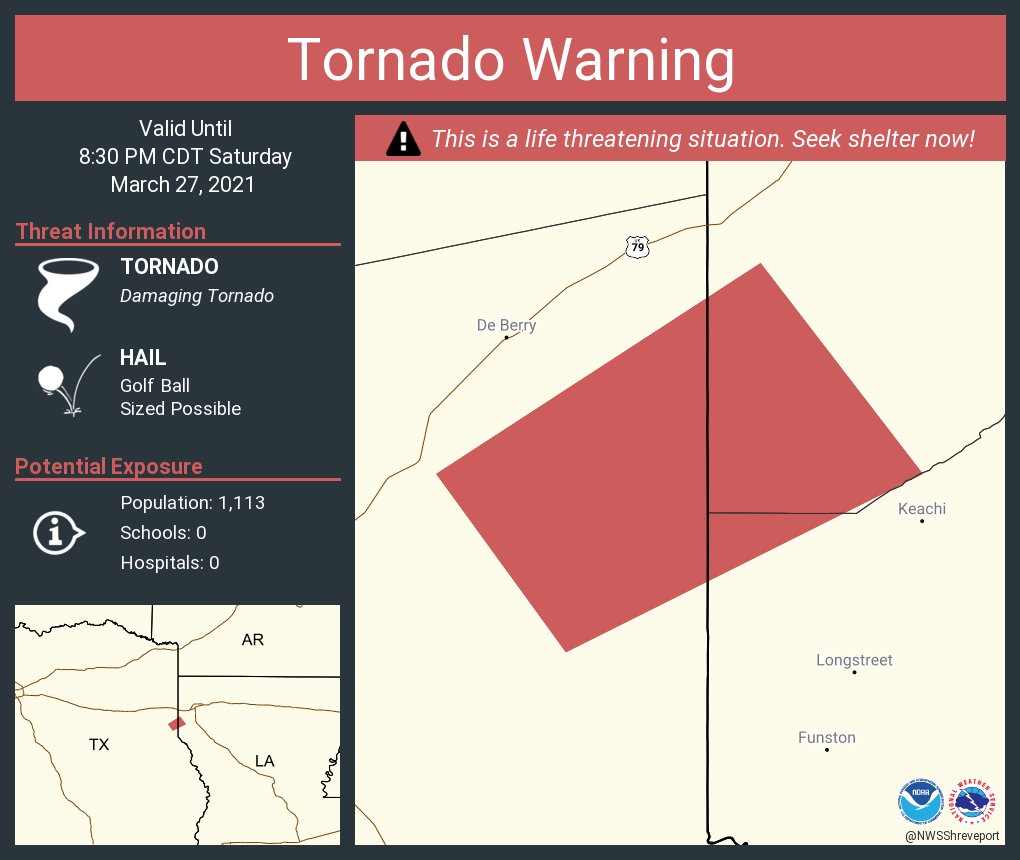
This is for the storm southwest of Shreveport:
...A TORNADO WARNING REMAINS IN EFFECT UNTIL 830 PM CDT FOR WEST
CENTRAL DE SOTO...SOUTHWESTERN CADDO PARISHES IN NORTHWESTERN
LOUISIANA AND EAST CENTRAL PANOLA COUNTIES...
At 754 PM CDT, a confirmed large and extremely dangerous tornado was
located near Carthage, moving northeast at 30 mph.
This is a PARTICULARLY DANGEROUS SITUATION. TAKE COVER NOW!

Posted on 3/27/21 at 8:03 pm to Roll Tide Ravens
Posted on 3/27/21 at 8:03 pm to hubreb
quote:
How bout collierville tn?
Will be close if it holds together and is on the ground.
Posted on 3/27/21 at 8:05 pm to LegendInMyMind
I'm in South Shreveport just north of the caddo/desoto line. I'm about to have a close call with this storm
Posted on 3/27/21 at 8:05 pm to Bobby OG Johnson
Posted on 3/27/21 at 8:05 pm to Roll Tide Ravens
Shreveport storm may be cycling right now. Rotation doesn't look as strong as it did. Still, find shelter if you're south of Shreveport.
This post was edited on 3/27/21 at 8:06 pm
Posted on 3/27/21 at 8:06 pm to Lsuhoohoo
quote:
I'm in South Shreveport just north of the caddo/desoto line. I'm about to have a close call with this storm
Looks to be heading straight toward Stonewall.
Posted on 3/27/21 at 8:07 pm to Lsuhoohoo
quote:
I'm in South Shreveport just north of the caddo/desoto line. I'm about to have a close call with this storm
Take shelter. Storm is cycling, meaning tornado is going strong to weak/lifting. It's got a good environment and nothing to interfere.
Don't trust a storm like this, find that safe space soon.
Posted on 3/27/21 at 8:08 pm to Bobby OG Johnson
Wow, that cell SW of Shreveport. Clean inflow and in a pretty dangerous environment. Heads up.
Posted on 3/27/21 at 8:09 pm to Duke
I'm about 7 miles north of stonewall. Looking like the storm is going to stay south of me but I'm on alert watching news and my apps ready to shelter if I need
Posted on 3/27/21 at 8:09 pm to Bobby OG Johnson
Posted on 3/27/21 at 8:09 pm to Duke
Strong rotation on the storm east of Pine Bluff.
Posted on 3/27/21 at 8:12 pm to Roll Tide Ravens
We’re in south shreveport about to get to closet. Lovely sat evening
Posted on 3/27/21 at 8:12 pm to Roll Tide Ravens
This is/was the tornado from the storm southwest of Shreveport. Photo was taken as it approached Carthage, TX. From Brad Hlozek on Twitter:
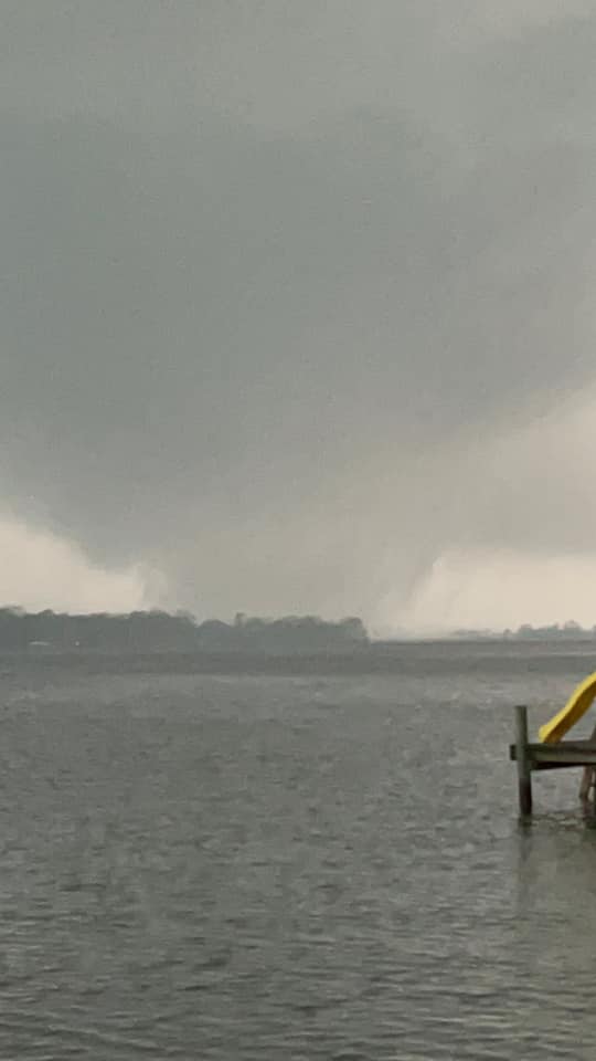
This post was edited on 3/27/21 at 8:14 pm
Posted on 3/27/21 at 8:12 pm to hubreb
quote:
How bout collierville tn?
Should pass to the North of Collierville.
Posted on 3/27/21 at 8:12 pm to Roll Tide Ravens
Oh wow. frick that.

 Page 78 of 86

Popular
Back to top