- My Forums
- Tiger Rant
- LSU Recruiting
- SEC Rant
- Saints Talk
- Pelicans Talk
- More Sports Board
- Fantasy Sports
- Golf Board
- Soccer Board
- O-T Lounge
- Tech Board
- Home/Garden Board
- Outdoor Board
- Health/Fitness Board
- Movie/TV Board
- Book Board
- Music Board
- Political Talk
- Money Talk
- Fark Board
- Gaming Board
- Travel Board
- Food/Drink Board
- Ticket Exchange
- TD Help Board
Customize My Forums- View All Forums
- Show Left Links
- Topic Sort Options
- Trending Topics
- Recent Topics
- Active Topics
Started By
Message
re: UPDATE: Another Potential Severe Weather Event for the South (insert dates)
Posted on 3/25/21 at 5:47 pm to slackster

Posted on 3/25/21 at 5:47 pm to slackster
quote:
Spann having the chaser turn around and head back for a good shot. Haha.
That was really funny
Spann: Hey where are you guys?
Chasers: We are heading south and you should see something here up ahead
Spann: Well you are heading close to the county line. You need to turn around because the circulation will be north of you, not south - You are going in the wrong direction
Immediately jumps back to radar and off the chaser
 0
0

Posted on 3/25/21 at 5:47 pm to Bobby OG Johnson
That looks like high end EF3 or EF4 stuff

Posted on 3/25/21 at 5:48 pm to Bobby OG Johnson

Posted on 3/25/21 at 5:48 pm to Bobby OG Johnson
This convection to the south has to start choking it off, no?

Posted on 3/25/21 at 5:48 pm to Bobby OG Johnson
it's heading to a very rural area which is a slight positive
Posted on 3/25/21 at 5:48 pm to Bobby OG Johnson
quote:
WSFA 12 News
@wsfa12news
"Multiple vortex tornado just crossed I-65" just south of Calera - Stormchaser @BrandonCopicWx live on WSFA 12 News.

Posted on 3/25/21 at 5:49 pm to Bobby OG Johnson
Is that the one that touched down around Roebuck?
Posted on 3/25/21 at 5:50 pm to Bobby OG Johnson

Posted on 3/25/21 at 5:51 pm to NorthEndZone
Bad thing is that AL highway 25 runs to the ENE and the tornado may track along it where there is more population.
Posted on 3/25/21 at 5:51 pm to slackster
Storm leading SW of Eurasia might be an issue soon.
Posted on 3/25/21 at 5:52 pm to HempHead
quote:
Is that the one that touched down around Roebuck?
No.
Posted on 3/25/21 at 5:52 pm to Bobby OG Johnson
I had a call. How did it look going through Calera?
Posted on 3/25/21 at 5:53 pm to slackster
quote:
Eurasia
That's gotta be way out of my market.
Posted on 3/25/21 at 5:53 pm to LegendInMyMind
Looks like it missed most of it.
Posted on 3/25/21 at 5:54 pm to WRhodesTider
wait... there's an Egg & Butter Road? 
Posted on 3/25/21 at 5:54 pm to rt3
We have a town called Slapout. What do you think?

Posted on 3/25/21 at 5:54 pm to LegendInMyMind
quote:
I had a call. How did it look going through Calera?
Look like it went just south of the core of Calera. Storm chasers reported it as a multiple vortex tornado when it crossed I-65.
Posted on 3/25/21 at 5:54 pm to rt3
quote:
wait... there's an Egg & Butter Road?
Son, there is a town called Bacon and Eggs.
Don't know why I said "son". It just felt right in that sentence.
This post was edited on 3/25/21 at 5:56 pm
Posted on 3/25/21 at 5:55 pm to Bobby OG Johnson
https://mobile.twitter.com/justin_wx_/status/1375204152452771846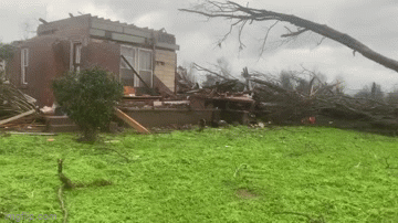
quote:
WxJustin
@justin_wx_
Greensboro AL
@spann
@NWSBirmingham
@NWStornado
Posted on 3/25/21 at 5:55 pm to slackster
quote:
Storm leading SW of Eurasia might be an issue soon.
Utah or whatever.
Yeah, it's got some big returns well above the freezing level and what zdr would suggest to be liquid water well above the freezing level. So updraft. Not seeing much rotation though, but anything with good vertical motion has to be watched in this environment.

 Page 54 of 86

Back to top