- My Forums
- Tiger Rant
- LSU Recruiting
- SEC Rant
- Saints Talk
- Pelicans Talk
- More Sports Board
- Coaching Changes
- Fantasy Sports
- Golf Board
- Soccer Board
- O-T Lounge
- Tech Board
- Home/Garden Board
- Outdoor Board
- Health/Fitness Board
- Movie/TV Board
- Book Board
- Music Board
- Political Talk
- Money Talk
- Fark Board
- Gaming Board
- Travel Board
- Food/Drink Board
- Ticket Exchange
- TD Help Board
Customize My Forums- View All Forums
- Show Left Links
- Topic Sort Options
- Trending Topics
- Recent Topics
- Active Topics
Started By
Message
re: Tuesday Severe weather for the Gulf Coast/Snowstorm for Arkansas
Posted on 1/24/23 at 3:14 pm to LegendInMyMind
Posted on 1/24/23 at 3:14 pm to LegendInMyMind
quote:
DFW was never at threat for this setup. The ingredients were never going to make it that far North.
What’s your take on SWLA/Lake Charles area? The “enhanced threat” area is doesn’t extend for north at all but quickly widens as it moves east.
 0
0

Posted on 1/24/23 at 3:14 pm to The Boat
That was a different rotation that developed Southeast of the earlier tornado. That bit of line has been cyclical with the main inflow dying and then getting going again as the previous meso died. Would be a good one to get an extended loop on.
This post was edited on 1/24/23 at 3:14 pm

Posted on 1/24/23 at 3:27 pm to Got Blaze
quote:
I completely understand brother just sharing info I copied from people who are on the ground and live in that area of Texas.
Yes sir, I got ya. I didn’t mean that as a jab at you if it came across that way. Just don’t like when people in the weather community in general (particularly chasers and streamers) start throwing numbers around prematurely.

Posted on 1/24/23 at 3:33 pm to LegendInMyMind
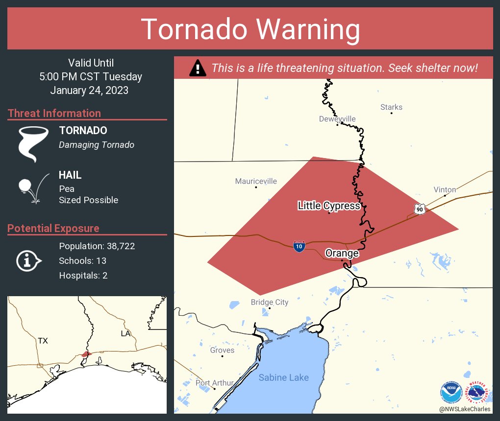
NWS Lake Chuck fricked up with this tornado warning polygon. The tornado is on the ground outside of the polygon. Trashy return too so it's hard to see. Looks like it was brief but the tight couplet was there.
This post was edited on 1/24/23 at 3:36 pm
Posted on 1/24/23 at 3:41 pm to The Boat
quote:
NWS Lake Chuck fricked up with this tornado warning polygon. The tornado is on the ground outside of the polygon. Trashy return too so it's hard to see. Looks like it was brief but the tight couplet was there.
Which direction was it out? I haven't able to look very much.
Posted on 1/24/23 at 3:42 pm to LegendInMyMind
It was upstream of the polygon. They were expecting it to move east but it raced off to the northeast instead.
Posted on 1/24/23 at 3:45 pm to The Boat
Boat and other weather gurus - thx for the play x play and color commentary. Many of us are fascinated by Mother Nature, but we don't know shite when it comes to pixelated TV screens resembling a tye died T-shirt. 
Posted on 1/24/23 at 4:01 pm to The Boat
Snow/Rain showers, now all snow but no accumulation as of yet
Posted on 1/24/23 at 4:14 pm to Got Blaze
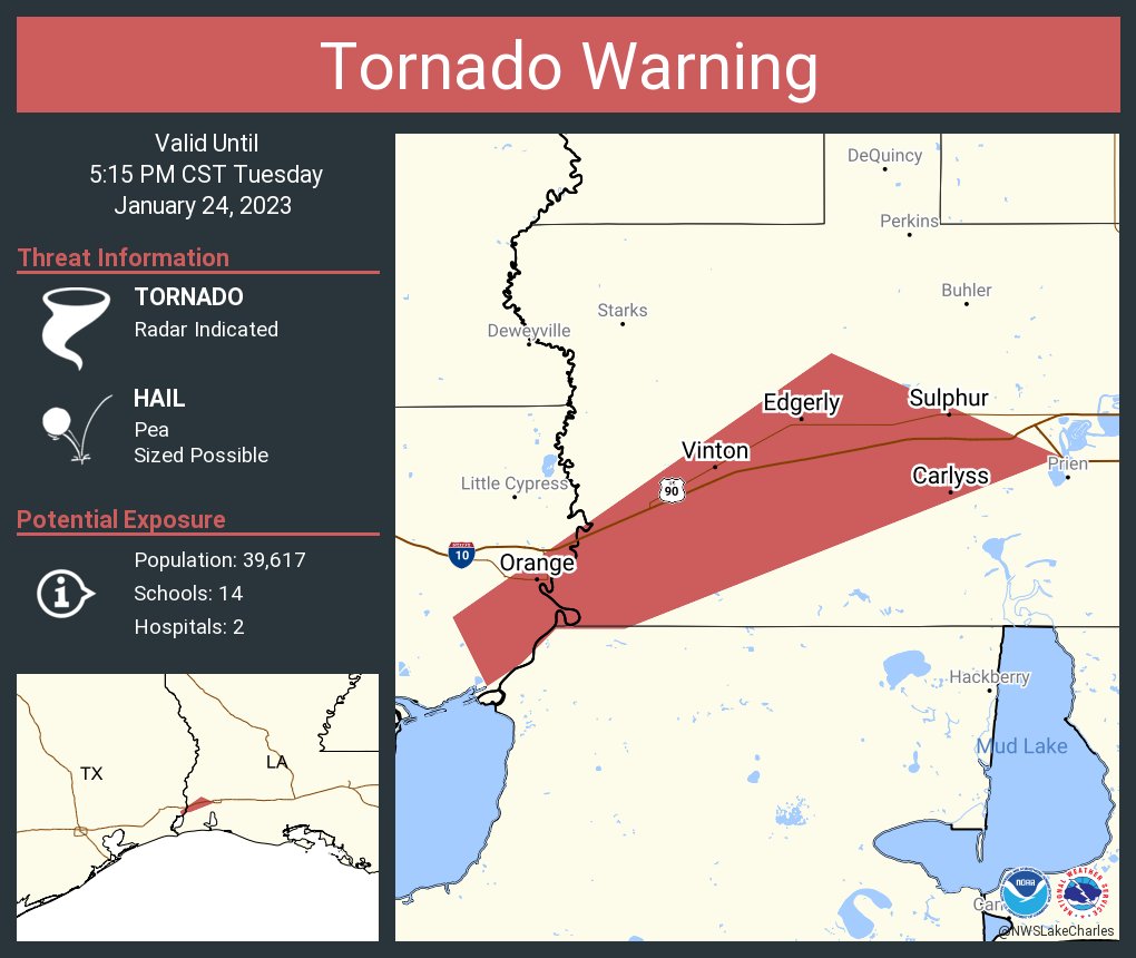
This squall line is spinning up tornadoes all over the place. Pretty short lived but once just raced up between Winnie and Port Arthur. Another trying to form just south of Beaumont. This is some QLCS tornadogenesis porn
Posted on 1/24/23 at 4:15 pm to wfallstiger
Port Arthur under gun for confirmed tornado
412 PM CST Tue Jan 24 2023
...A TORNADO WARNING REMAINS IN EFFECT UNTIL 430 PM CST FOR CENTRAL
JEFFERSON COUNTY...
At 412 PM CST, a confirmed tornado was located over La Belle, or 10
miles southwest of Central Gardens, moving northeast at 50 mph.
HAZARD...Damaging tornado.
SOURCE...Radar confirmed tornado.
IMPACT...Flying debris will be dangerous to those caught without
shelter. Mobile homes will be damaged or destroyed. Damage
to roofs, windows, and vehicles will occur. Tree damage is
likely.
This tornado will be near...
Port Acres around 420 PM CST.
Port Arthur around 425 PM CST.
Posted on 1/24/23 at 4:20 pm to The Boat
shite is nasty ... heads up PA, Bridge City, and Orange

Posted on 1/24/23 at 4:26 pm to The Boat
quote:
Another trying to form just south of Beaumont.
Finally got one

Posted on 1/24/23 at 4:28 pm to The Boat
quote:
Brad Arnold
@BradArnoldWX
·
8m
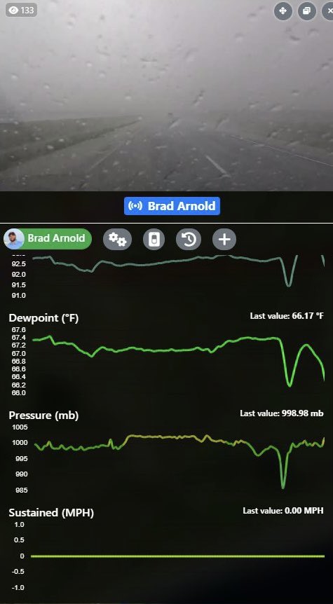
This is HUGE!!! I just registered a huge pressure drop inside the tornado near Taylor Landing, TX!!
Posted on 1/24/23 at 4:29 pm to The Boat
those storm chasers are 2 slices of bread short of a sammich
dude is on I-10 which I circled in white - Phukin' Nuts !

dude is on I-10 which I circled in white - Phukin' Nuts !
Posted on 1/24/23 at 4:37 pm to Got Blaze
Posted on 1/24/23 at 4:40 pm to Bobby OG Johnson
That is a doozy. That tornado is about to cross into Louisiana and get our party started here.
Posted on 1/24/23 at 4:41 pm to The Boat
quote:
Spotter Network Inc
@spotternetwork
·
1m
Spotr 4 miles WNW of ORANGE, TX @ 22:39 UTC TOR>-Strong tornado crossed at this location. powerlines down vehicles flipped extensive damage
Posted on 1/24/23 at 4:42 pm to Bobby OG Johnson
Posted on 1/24/23 at 4:44 pm to Bobby OG Johnson
They closed ups early in Lafayette

 Page 9 of 28

Popular
Back to top