- My Forums
- Tiger Rant
- LSU Recruiting
- SEC Rant
- Saints Talk
- Pelicans Talk
- More Sports Board
- Coaching Changes
- Fantasy Sports
- Golf Board
- Soccer Board
- O-T Lounge
- Tech Board
- Home/Garden Board
- Outdoor Board
- Health/Fitness Board
- Movie/TV Board
- Book Board
- Music Board
- Political Talk
- Money Talk
- Fark Board
- Gaming Board
- Travel Board
- Food/Drink Board
- Ticket Exchange
- TD Help Board
Customize My Forums- View All Forums
- Show Left Links
- Topic Sort Options
- Trending Topics
- Recent Topics
- Active Topics
Started By
Message
 1
1


Posted on 9/17/19 at 7:51 pm to Cosmo
Yeah basically when this thing became a TS things started to change. It seems much smaller and moving faster than they thought last night and this morning.
Posted on 9/17/19 at 8:12 pm to Champagne
My Ex in Houston said they are sandbagging bracing for flash flood. First I heard of it, what say you?

Posted on 9/17/19 at 8:20 pm to bigberg2000
Berg you gonna flood man
Posted on 9/17/19 at 8:25 pm to BogeyGolf
Harris County FWS
You can watch the rain gages and bayou levels here
You can watch the rain gages and bayou levels here
Posted on 9/17/19 at 8:33 pm to bigberg2000
quote:
Yeah basically when this thing became a TS things started to change.
Nothing has changed. The WPC forecast hasn't really changed for days. The slow drift north has always been the projection.
The worry is our high res models are coming in very aggressive on the rainfall. HRRR has 21" falling in 14 hours. NAM is over 30" in 50 hours. Euro painting almost 30". Those are max values for the region of course, but there's plenty flashing for some huge rain totals.

Posted on 9/17/19 at 8:40 pm to Duke
quote:seems like most of this is south and to the east, right? Today hasn't been too bad for west houston
The worry is our high res models are coming in very aggressive on the rainfall. HRRR has 21" falling in 14 hours. NAM is over 30" in 50 hours. Euro painting almost 30". Those are max values for the region of course, but there's plenty flashing for some huge rain totals.
Posted on 9/17/19 at 8:42 pm to Duke
My bad. Just got that from the local meteorologist at about 2 today. He had the highest totals at 15 and said it’s because it isn’t supposed to stall. 

Posted on 9/17/19 at 8:44 pm to Cosmo
Has Assumption Parish canceled school yet?
This post was edited on 9/17/19 at 8:45 pm

Posted on 9/17/19 at 8:46 pm to Duke
quote:
HRRR has 21" falling in 14 hours.
That doesnt seem possible
Posted on 9/17/19 at 8:49 pm to Cosmo
This reminds me of Hurricane Humberto in 2007 that went from nothing to 90 mph overnight and made landfall around the same area.. a little farther east. It intensified faster than any hurricane ever in the Atlantic basin.

It was pretty impressive on radar for having such a short life.
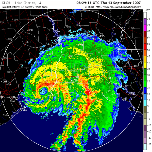
It was pretty impressive on radar for having such a short life.
Posted on 9/17/19 at 8:55 pm to Cosmo
quote:
That doesnt seem possible
It's possible. Saw 5.5" in 90 minutes here back in June. Wouldn't call it likely though. It's more just the signal of ridiculous rainfall that has my attention, not the actual total.
Posted on 9/17/19 at 8:58 pm to msutiger
quote:
went to Kroger at lunch in Pearland and it was business as usual
I was in Lake Jackson this afternoon and early evening. There was a stiff dew, but nothing approaching tropical storm-ish. Seemed like business as usual there too.
This post was edited on 9/17/19 at 9:02 pm
Posted on 9/17/19 at 9:05 pm to bigberg2000
quote:
My bad. Just got that from the local meteorologist at about 2 today. He had the highest totals at 15 and said it’s because it isn’t supposed to stall.
Just filling in some detail. Your local guy was explaining the official forecast as they should.
I was more or less highlighting not much has changed on forward motion. It's come in a little sooner but it's still going to kind of slowly drift north.
Then spoke to the fact there is high end rainfall potential, but that's not in the official forecast that maxes out about 15". More about highlighting the high end but lower probability impacts.
Posted on 9/17/19 at 9:08 pm to WestCoastAg
quote:
seems like most of this is south and to the east, right? Today hasn't been too bad for west houston
Yes.
It's the coastal counties, southern parts of Harris, and parts east and eventually to the NE that are more consistently getting pinged for the higher end totals.
Basically south and east of the center are going to be getting the onshore flow and all the moisture funneling in.
Posted on 9/17/19 at 9:13 pm to Duke
In Nassau Bay, it has been a steady rainfall all day long. A few heavy downpours but the water level in the boat canals hasn't risen very much. No lightning or thunder at all.
Posted on 9/17/19 at 9:20 pm to OldTigahFot
My rain gauge is showing 8 inches since last night in League City. No Harvey like rain so far. At times during Harvey we were getting 3 inches per hour here.
Posted on 9/17/19 at 10:06 pm to p0845330
I was in Freeport/Lake Jackson all morning and nada as far as TS type weather goes. Just some rain.
Posted on 9/17/19 at 10:10 pm to tk for tu juan
Posted on 9/17/19 at 11:20 pm to tk for tu juan
When I look at this system on Full Screen Radar, it doesn't look like anything close to Harvey.
I think that Houston will be OK.
I think that Houston will be OK.

 Page 24 of 30

Popular
Back to top