- My Forums
- Tiger Rant
- LSU Recruiting
- SEC Rant
- Saints Talk
- Pelicans Talk
- More Sports Board
- Coaching Changes
- Fantasy Sports
- Golf Board
- Soccer Board
- O-T Lounge
- Tech Board
- Home/Garden Board
- Outdoor Board
- Health/Fitness Board
- Movie/TV Board
- Book Board
- Music Board
- Political Talk
- Money Talk
- Fark Board
- Gaming Board
- Travel Board
- Food/Drink Board
- Ticket Exchange
- TD Help Board
Customize My Forums- View All Forums
- Show Left Links
- Topic Sort Options
- Trending Topics
- Recent Topics
- Active Topics
Started By
Message
re: Tropical Storm Nicholas - Flash Flood Watch for South Louisiana
Posted on 9/13/21 at 11:05 pm to LegendInMyMind

Posted on 9/13/21 at 11:05 pm to LegendInMyMind
Tell me Iike Im 5
This post was edited on 9/13/21 at 11:06 pm
 3
3

Posted on 9/13/21 at 11:06 pm to Cosmo
Rob perillo is a doom caster.
Posted on 9/13/21 at 11:06 pm to Cosmo

New GFS not super bullish on rain
Posted on 9/13/21 at 11:07 pm to Paul Allen
quote:
Which part of Houston?
Just says primarily south of I-10.
According to CenterPoint Energy, 38,036 customers are currently without power.
Not much else in the link really.
LINK
This post was edited on 9/13/21 at 11:09 pm

Posted on 9/13/21 at 11:08 pm to Cosmo
Let’s do that one

Posted on 9/13/21 at 11:10 pm to Duke
quote:
The 00z HRRR was, suboptimal for all of Louisiana south of I10, but lets put a pin in that as an outlier.
The 00z 3kNAM put over 12" across the bayou parishes and spotty big total across the Louisiana coast.
The FV3 had similar spots of rainfall pushing a foot along the Louisiana coast, and specifically SELA.
Enough there to think some parts of Louisiana are going to break a foot of rain. Just, you know, always a motherfricker to figure out exactly where.
Boooooooooooooooooo
Posted on 9/13/21 at 11:11 pm to LegendInMyMind
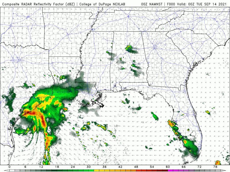
Here's what I was talking about earlier when I said that shear opens it up and pushes the convection Eastward pretty much across the entirety of Southern Lousiana.
What will determine the rainfall amounts and where they are will be where the heaviest bands set up, how fast they are moving, and how much of the heavier precip stays offshore.
This is the simulated radar from the NAM Nest through Thursday.
What will determine the rainfall amounts and where they are will be where the heaviest bands set up, how fast they are moving, and how much of the heavier precip stays offshore.
This is the simulated radar from the NAM Nest through Thursday.
Posted on 9/13/21 at 11:13 pm to LegendInMyMind
Well none of that looks good for any of SELA at all
Posted on 9/13/21 at 11:14 pm to Cosmo
quote:
What is the difference between the various NAMs?
Resolution.
The big thing on the 3km is that its convective allowing, meaning its got a small enough scale to depict individual cells (you need like under 6 km x 6 km grids to really do this) and does a lot less assuming around vertical motion.
When trying to spot really high rainfall, they're better to look at.
The HREF, which you can access off the SPC site, is an ensemble of a bunch of them.

Posted on 9/13/21 at 11:15 pm to LegendInMyMind
quote:
NAM
The Viet Cong never quits.

Posted on 9/13/21 at 11:16 pm to LegendInMyMind
I’m putting the decoys out, they usually scare the storms away.
Posted on 9/13/21 at 11:17 pm to Cosmo
quote:
Tell me Iike Im 5
The way I've always understood it is that when programming the model you basically take a grid and lay it over/across a given area. That grid has points set at different, evenly-spaced intervals. With the NAM, those points are spaced at either 32km, 12km, or 3km between each point. The closer the point the higher the resolution. The higher the resolution, the more details you get. So, the NAM 3k is the higher res of the three, and will give you a clearer, more detailed idea of what could happen. However, because higher res models take more computer power to run, they can't be run at long range. To help with that, they are ran more often.
This post was edited on 9/13/21 at 11:19 pm

Posted on 9/13/21 at 11:19 pm to LegendInMyMind

Posted on 9/13/21 at 11:20 pm to Bayou_Tiger_225
Thanks Ollie
Posted on 9/13/21 at 11:21 pm to Impotent Waffle
So basically its going to start raining tomorrow morning and not stop till Friday? And no one is really sure exactly how much rain we gonn get...
This post was edited on 9/13/21 at 11:25 pm

Posted on 9/13/21 at 11:23 pm to Impotent Waffle
Basically maybe
Posted on 9/13/21 at 11:23 pm to Impotent Waffle
Yes
Posted on 9/13/21 at 11:27 pm to Bullfrog
quote:
Basically maybe
60% of the time, it works every time??
Posted on 9/13/21 at 11:39 pm to Bullfrog
Perhaps
Posted on 9/13/21 at 11:40 pm to Impotent Waffle
Is there any local news coverage on this storm? Local ad in Houston. I only found the local fox channel with coverage, but even that was just the freaking Isiah factor doing it. Not like legit coverage. NBC, CBS and ABC had their regular late night talk shows.
Eta: fox with regular programming now too.
Eta: fox with regular programming now too.
This post was edited on 9/13/21 at 11:43 pm

 Page 33 of 55

Popular
Back to top