- My Forums
- Tiger Rant
- LSU Recruiting
- SEC Rant
- Saints Talk
- Pelicans Talk
- More Sports Board
- Fantasy Sports
- Golf Board
- Soccer Board
- O-T Lounge
- Tech Board
- Home/Garden Board
- Outdoor Board
- Health/Fitness Board
- Movie/TV Board
- Book Board
- Music Board
- Political Talk
- Money Talk
- Fark Board
- Gaming Board
- Travel Board
- Food/Drink Board
- Ticket Exchange
- TD Help Board
Customize My Forums- View All Forums
- Show Left Links
- Topic Sort Options
- Trending Topics
- Recent Topics
- Active Topics
Started By
Message

 1
1

Posted on 7/29/20 at 12:01 pm to shallowminded
quote:
The track keeps moving a little further of the west coast of Florida. You think this thing could get out far enough in the gulf and explode into a good cat 2/3?
The more west it goes, the less chance it has of becoming a hurricane. The better chance would be for it to gain decent TS strength by tomorrow and stay East of Puerto Rico where it could fight off the sheer from the UL trough to its north and west.
Posted on 7/29/20 at 12:48 pm to Duke
The northern portion of the wave is also starting to get sheared by an upper level feature (PVS/ULL). Convection will be favored downshear in the area of enhanced upper level divergence. The latest run of the GFS favors the northern portion of the wave for future development possibly due to enhanced convection and the reasons you mentioned. However, the models have been too fast to kill off the southern portion of the wave for a while now.
ETA: 12z Euro also keys in on the northern portion (which makes sense) and lifts the system out east of Florida. This track would also give it a bit more time before being overrun by the incoming trough.
ETA: 12z Euro also keys in on the northern portion (which makes sense) and lifts the system out east of Florida. This track would also give it a bit more time before being overrun by the incoming trough.
This post was edited on 7/29/20 at 1:37 pm
Posted on 7/29/20 at 1:18 pm to rds dc
Alrighty then. What does all of that mean?
Posted on 7/29/20 at 1:28 pm to rds dc
quote:
However, the models have been too fast to kill off the southern portion of the wave for a while now.

Posted on 7/29/20 at 2:02 pm to rds dc


Posted on 7/29/20 at 2:04 pm to Python
This afternoon's models are in more agreement that it will go to the east of Florida and miss the Gulf altogether.
As long as that trough develops like all the models think it will, this system will either be destroyed or go east of Florida. Probably both, to be honest.
Looking at the models and further east closer to Africa, we're likely going to have a quiet few weeks unless we get one of those home brew systems that form out of nowhere in the gulf. That's always possible during hurricane season.
The week before, week of, and week after Labor Day always proves to be exciting. I wonder if it'll be that way again this year.
Posted on 7/29/20 at 2:05 pm to TDsngumbo
music to my ears!


Posted on 7/29/20 at 4:22 pm to TDsngumbo
What are your credentials baw?
eta: hispaniola is gonna eat this storm for breakfast
eta: hispaniola is gonna eat this storm for breakfast
This post was edited on 7/29/20 at 4:23 pm
Posted on 7/29/20 at 4:42 pm to Cosmo
quote:
hispaniola is gonna eat this storm for breakfast
If it doesn't really form a center and is still having these dueling lobes, maybe Hispaniola eating half the system helps the other half coming off of the island.
Posted on 7/29/20 at 4:50 pm to Cosmo
quote:
What are your credentials baw?
No need for credentials when you're simply repeating what experts are saying.
Posted on 7/29/20 at 4:57 pm to TDsngumbo
It has not been able to form up for 2 days now. Give it some Viagra.
I always read the discussion section. They don't even know about all the windshear chopping it up. Doofusses look at the cone and spaghetti models and maybe the forecast.
I always read the discussion section. They don't even know about all the windshear chopping it up. Doofusses look at the cone and spaghetti models and maybe the forecast.
This post was edited on 7/29/20 at 4:58 pm
Posted on 7/29/20 at 4:59 pm to rds dc
FWIW, a friend in Puerto Rico and a friend in Miami are both laughing at how the local weather reporters have disappointment in their voices at it not forming up
Posted on 7/29/20 at 7:05 pm to CitizenK
quote:
Friend in Puerto Rico and a friend in Miami
Right. People like you don’t have friends. You saw this on TikTok?
Posted on 7/29/20 at 7:29 pm to JAlohaM
Let’s let this static chill out.......
Posted on 7/29/20 at 7:30 pm to rds dc
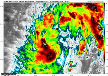
8:00 pm NHC location is a shift SW from the previous advisory and there is currently a pretty nice burst of convection in that area. 18z Euro is weak and into S. FL.

Posted on 7/29/20 at 7:40 pm to rds dc
Ok, Yoda. What do YOU think it’s gonna do?


 Page 31 of 50

Popular
Back to top