- My Forums
- Tiger Rant
- LSU Recruiting
- SEC Rant
- Saints Talk
- Pelicans Talk
- More Sports Board
- Fantasy Sports
- Golf Board
- Soccer Board
- O-T Lounge
- Tech Board
- Home/Garden Board
- Outdoor Board
- Health/Fitness Board
- Movie/TV Board
- Book Board
- Music Board
- Political Talk
- Money Talk
- Fark Board
- Gaming Board
- Travel Board
- Food/Drink Board
- Ticket Exchange
- TD Help Board
Customize My Forums- View All Forums
- Show Left Links
- Topic Sort Options
- Trending Topics
- Recent Topics
- Active Topics
Started By
Message
re: Tropical Storm Debby - Flooding Threat Slowly Shifting NE
Posted on 8/1/24 at 6:47 pm to rds dc
Posted on 8/1/24 at 6:47 pm to rds dc
Tropical Weather Outlook
NWS National Hurricane Center Miami FL
800 PM EDT Thu Aug 1 2024
For the North Atlantic...Caribbean Sea and the Gulf of Mexico:
Straits of Florida and Eastern Gulf of Mexico (AL97):
A well-defined tropical wave is producing a large area of
disorganized showers and thunderstorms over Hispaniola, the
southeastern Bahamas, and the adjacent waters of the southwestern
Atlantic. The wave is expected to move west-northwestward near or
over Cuba on Friday and then emerge over the Straits of Florida
Friday night or Saturday. Environmental conditions are expected to
be conducive for additional development after that time, and a
tropical depression is likely to form this weekend over the Straits
of Florida or eastern Gulf of Mexico near the Florida Peninsula.
Regardless of development, heavy rains could cause areas of flash
flooding across Florida, Cuba, and the Bahamas through the weekend,
and interests in these locations should continue to monitor the
progress of this system. A NOAA Hurricane Hunter aircraft is
scheduled to investigate this system on Friday, if necessary.
* Formation chance through 48 hours...medium...40 percent.
* Formation chance through 7 days...high...70 percent.
$$
Forecaster Berg
Hopefully they don't cancel and we'll start getting data on it tomorrow
 1
1


Posted on 8/1/24 at 6:51 pm to lsuman25
Models kinda tightening up?

Posted on 8/1/24 at 8:20 pm to LanierSpots
Loading Twitter/X Embed...
If tweet fails to load, click here. quote:
Last couple GFS runs are on the eastern side of track possibilities for Invest #97L. In this scenario (first animation), the very northern tip of the wave slides north of Cuba and becomes the anchor for tropical storm formation.
This leads to a track farther east, very close to the Florida Peninsula. More importantly, this track also gets north quicker, allowing the storm to be guided across Florida by the trough to the north prior to getting stranded in weak steering currents. The end result is a storm parked off the Carolinas. This is dramatically different than the GFS solution just 3 runs ago (second animation), which got stuck in the Gulf of Mexico due to a slightly more southerly initial track over Cuba.
This illustrates the importance of where 97L consolidates in the short-term. Small differences in the short-term track make a dramatic difference later on these runs. Model forecasts will likely converge as 97L becomes better organized.

Posted on 8/1/24 at 8:32 pm to LegendInMyMind
Great analysis from Levi.
Posted on 8/1/24 at 8:35 pm to Roll Tide Ravens
He is the best
Posted on 8/1/24 at 9:07 pm to rds dc
Idk, I’m like Levi, the models are wack. It’s wide open on the track.
I think he thinks something is brewing.
Watch his today
I think he thinks something is brewing.
Watch his today
Posted on 8/1/24 at 9:19 pm to rds dc
Here is the best estimate of where the low-level circulation is located by the professionals at NOAA...

This post was edited on 8/1/24 at 9:21 pm

Posted on 8/1/24 at 9:24 pm to NorthEndZone
So just north of cuba
Posted on 8/1/24 at 9:30 pm to Cosmo
Yeah. The low level center could consolidate very close to the Cuban coast or a little farther north of there. The large majority of the models have it tracking right along the coast into the Florida straits.
This post was edited on 8/1/24 at 9:49 pm
Posted on 8/1/24 at 9:32 pm to NorthEndZone
I hate to be the bingo card guy, we are currently in Cape San Blas until Saturday. I see the state of emergency declared and everything. We intend on leaving Saturday morning at 7 am hurricane or not, do we need to plan to leave earlier? Expect more traffic?
ETA: it's remote Florida, we don't touch an interstate on the way home. Only in Florida for an hour or 2 until we hit 231 and cruise up Alabama.
ETA: it's remote Florida, we don't touch an interstate on the way home. Only in Florida for an hour or 2 until we hit 231 and cruise up Alabama.
This post was edited on 8/1/24 at 9:44 pm
Posted on 8/1/24 at 9:39 pm to BoogaBear
Leave at 5am. If that area is in the cone come Friday night, the panic will ensue Saturday mid morning once everyone wakes up
Posted on 8/1/24 at 9:39 pm to BoogaBear
The center is still likely to be south of the Keys on Saturday morning. You should be fine on that schedule. But the earlier you leave the better as far as traffic goes - especially if it looks to be strengthening on Friday night.
This post was edited on 8/1/24 at 9:41 pm
Posted on 8/1/24 at 9:45 pm to GeauxTigers80
quote:
the models are wack. It’s wide open on the track.
Im with ya. Someone is about to take something on the chin. Hopefully it doesn’t get too nasty. Now a days the closer to shore they get way more nasty!
Posted on 8/1/24 at 9:49 pm to GeauxTigers80
quote:
Idk, I’m like Levi, the models are wack. It’s wide open on the track.
Pretty much all models are in good agreement with the latest runs as far as landfall goes. It is what happens after that still needs to be worked out.
Posted on 8/2/24 at 4:34 am to LegendInMyMind
quote:
Pretty much all models are in good agreement with the latest runs as far as landfall goes. It is what happens after that still needs to be worked out.
Looks that way. The fun part is going to see how much it changes on Saturday once it has a clear path away from land in the gulf.
Just for timing

This post was edited on 8/2/24 at 5:07 am
Posted on 8/2/24 at 5:20 am to LanierSpots
Shifting Westward.
Posted on 8/2/24 at 5:30 am to BoogaBear
I live in St Joe. I would take 71 to the interstate and then hop over to 231
Posted on 8/2/24 at 6:21 am to ticklechain
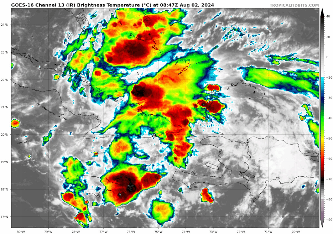
Looks like storms starting to fire off around the middle. Not sure if this is an indication of anything but looks cool.
Posted on 8/2/24 at 7:12 am to ticklechain
quote:
live in St Joe. I would take 71 to the interstate and then hop over to 231
We go 71>73> 231
Posted on 8/2/24 at 7:13 am to BoogaBear
quote:
We go 71>73> 231
That’s the way we go. Love that drive.

 Page 24 of 49

Popular
Back to top