- My Forums
- Tiger Rant
- LSU Recruiting
- SEC Rant
- Saints Talk
- Pelicans Talk
- More Sports Board
- Fantasy Sports
- Golf Board
- Soccer Board
- O-T Lounge
- Tech Board
- Home/Garden Board
- Outdoor Board
- Health/Fitness Board
- Movie/TV Board
- Book Board
- Music Board
- Political Talk
- Money Talk
- Fark Board
- Gaming Board
- Travel Board
- Food/Drink Board
- Ticket Exchange
- TD Help Board
Customize My Forums- View All Forums
- Show Left Links
- Topic Sort Options
- Trending Topics
- Recent Topics
- Active Topics
Started By
Message
Tornadoes in Illinois and Indiana - Chasers Tracking
Posted on 6/11/26 at 5:17 pm
Posted on 6/11/26 at 5:17 pm
quote:
BULLETIN - EAS ACTIVATION REQUESTED
Tornado Warning
National Weather Service Lincoln IL
511 PM CDT Thu Jun 11 2026
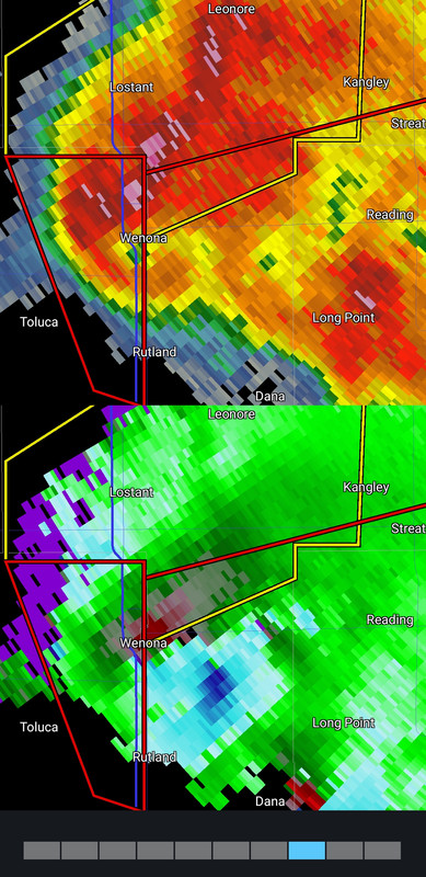
...TORNADO EMERGENCY FOR LA ROSE...TOLUCA...WENONA...
The National Weather Service in Lincoln has issued a
* Tornado Warning for...
Eastern Marshall County in central Illinois...
* Until 545 PM CDT.
* At 510 PM CDT, a confirmed large and destructive tornado was
observed over Washburn, or 8 miles southeast of Lacon, moving
northeast at 40 mph.
TORNADO EMERGENCY for LA ROSE...TOLUCA...WENONA. This is a
PARTICULARLY DANGEROUS SITUATION. TAKE COVER NOW!
HAZARD...Deadly tornado.
SOURCE...Emergency management confirmed tornado.
IMPACT...You are in a life-threatening situation. Flying debris
may be deadly to those caught without shelter. Mobile
homes will be destroyed. Considerable damage to homes,
businesses, and vehicles is likely and complete
destruction is possible.
* Locations impacted include...
Toluca, Wenona, Varna, and La Rose.
This includes Interstate 39 between mile markers 29 and 40.
PRECAUTIONARY/PREPAREDNESS ACTIONS...
To repeat, a large, extremely dangerous and potentially deadly
tornado is on the ground. To protect your life, TAKE COVER NOW! Move
to an interior room on the lowest floor of a sturdy building. Avoid
windows. If in a mobile home, a vehicle or outdoors, move to the
closest substantial shelter and protect yourself from flying debris.
A large and extremely dangerous tornado is on the ground. Take
immediate tornado precautions. This is an emergency situation.
&&
LAT...LON 4093 8905 4093 8930 4097 8936 4111 8917
4110 8905
TIME...MOT...LOC 2210Z 242DEG 36KT 4096 8928
TORNADO...OBSERVED
TORNADO DAMAGE THREAT...CATASTROPHIC
MAX HAIL SIZE...2.00 IN
This post was edited on 6/11/26 at 7:46 pm
 5
5

Posted on 6/11/26 at 5:30 pm to NorthEndZone
Great, just got into Chicago and it looks headed that way.
Posted on 6/11/26 at 5:34 pm to cubsfinger
Tornadic storms are about 50 miles from the SW Chicago suburbs. Other storms are closer passing through Rockford now.
quote:
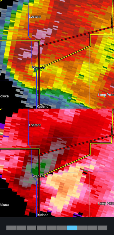
At 527 PM CDT, a confirmed large and extremely dangerous tornado was
located over Wenona, or 11 miles southwest of Streator, moving east
at 40 mph.
This is a PARTICULARLY DANGEROUS SITUATION. TAKE COVER NOW!
HAZARD...Damaging tornado.
SOURCE...Weather spotters confirmed tornado.
IMPACT...You are in a life-threatening situation. Flying debris may
be deadly to those caught without shelter. Mobile homes
will be destroyed. Considerable damage to homes,
businesses, and vehicles is likely and complete destruction
is possible.
The tornado will be near...
Streator and South Streator around 535 PM CDT.
Other locations impacted by this tornadic thunderstorm include Dana,
Ransom, Rutland, and Long Point.
This post was edited on 6/11/26 at 5:37 pm

Posted on 6/11/26 at 5:34 pm to cubsfinger
Yesterday afternoon in Chicago was crazy. Serious wind and lightning.
Decent line of storms came through when I was at Midway a bit ago too.
Decent line of storms came through when I was at Midway a bit ago too.
Posted on 6/11/26 at 5:35 pm to NorthEndZone
That main warned storm is ugly as shite, but is getting the job done. Ongoing cell merger......let's see what it does for it.
BWER earlier with it. From two different radars.
It is headed for areas that were hit pretty hard back in the Spring.
BWER earlier with it. From two different radars.
It is headed for areas that were hit pretty hard back in the Spring.
This post was edited on 6/11/26 at 5:38 pm
Posted on 6/11/26 at 5:46 pm to LegendInMyMind
In KC today. Wind was blowing fairly hard past two days but I think sort of born out here. Barely missed a few cells
Posted on 6/11/26 at 5:49 pm to LegendInMyMind
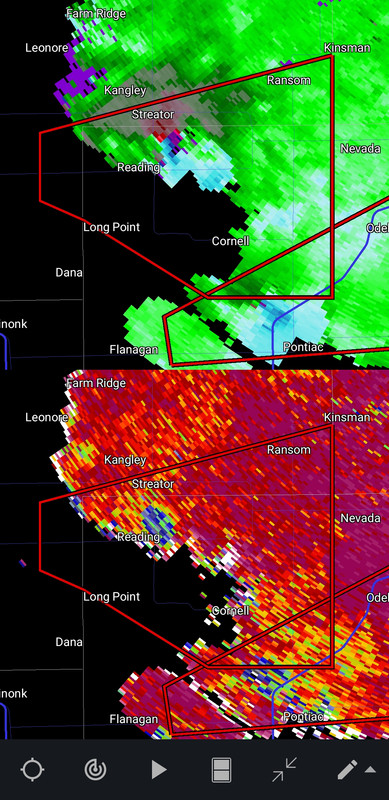
Looks like Reading took a direct hit. That TDS popped when it went over it.
This post was edited on 6/11/26 at 5:49 pm
Posted on 6/11/26 at 5:51 pm to LegendInMyMind
Hope it lifted/weakened as it passed in south Streator. Fairly populated areas.
This post was edited on 6/11/26 at 5:52 pm
Posted on 6/11/26 at 5:52 pm to Chad504boy
It doesn't correlate all that well to ground truth, but the TDS with that tornado was 2.5 miles wide, and it grew to that size in 1 radar cycle.
Posted on 6/11/26 at 5:53 pm to NorthEndZone
quote:
Hope it lifted/weakened as it passed in south Streator. Fairly populated areas.
It definitely looks to be on the ground on the southern edge of Streator.
Posted on 6/11/26 at 5:54 pm to NorthEndZone
The ugly storm to the south of this one is about to be a problem.

Posted on 6/11/26 at 5:58 pm to theOG
quote:
Yesterday afternoon in Chicago was crazy. Serious wind and lightning.
For real.
I was in my house doing an interview at 4:30 and it got dark as night.
I told the dude I was interviewing that I may cut it short cause it looked like Jumanji outside.
Posted on 6/11/26 at 5:59 pm to putt23
Josh Pate is chasing it
Posted on 6/11/26 at 6:02 pm to putt23
quote:
I told the dude I was interviewing that I may cut it short cause it looked like Jumanji outside.
I hope he responded:
"That is just the beginning. I’ve seen things you’ve only seen in your nightmares. Things you can’t even imagine. Things you can’t even see. There are things that hunt you in the night. Then something screams. Then you hear them eating, and you hope to God that you’re not dessert. Afraid? You don’t even know what afraid is. You would not last five minutes without me.”
Posted on 6/11/26 at 6:03 pm to dallastiger55
quote:
Josh Pate is chasing it
Is he the football YouTube dude?
Posted on 6/11/26 at 6:05 pm to LegendInMyMind
Calm down Alan!
Posted on 6/11/26 at 6:06 pm to dallastiger55
quote:
Josh Pate is chasing it
Pate State
Posted on 6/11/26 at 6:11 pm to LegendInMyMind
Massive hook echo running right along I-55. And a new possible tornado in Wisconsin near Kenosha - very populated.
Posted on 6/11/26 at 6:19 pm to NorthEndZone
The good news is that the southern storm has cut off a lot the inflow for the original warned storm. Bad news is that it is cranking now.
Had a quick spin up SE of Peoria near Deer Creek.
Had a quick spin up SE of Peoria near Deer Creek.
This post was edited on 6/11/26 at 6:21 pm
Posted on 6/11/26 at 6:25 pm to LegendInMyMind
I'm in Pingree Grove near Huntley.
To the North is white/blue sky and the South is black and the wind is gusting 30 mph.
The trees in the neighborhood are in a frenzy.
To the North is white/blue sky and the South is black and the wind is gusting 30 mph.
The trees in the neighborhood are in a frenzy.

 Page 1 of 2

Popular
Back to top