- My Forums
- Tiger Rant
- LSU Recruiting
- SEC Rant
- Saints Talk
- Pelicans Talk
- More Sports Board
- Fantasy Sports
- Golf Board
- Soccer Board
- O-T Lounge
- Tech Board
- Home/Garden Board
- Outdoor Board
- Health/Fitness Board
- Movie/TV Board
- Book Board
- Music Board
- Political Talk
- Money Talk
- Fark Board
- Gaming Board
- Travel Board
- Food/Drink Board
- Ticket Exchange
- TD Help Board
Customize My Forums- View All Forums
- Show Left Links
- Topic Sort Options
- Trending Topics
- Recent Topics
- Active Topics
Started By
Message

Tornado! Watch Issued for Most of Louisiana - Nocturnal Tornado Threat for Louisiana
Posted on 10/31/18 at 12:26 pm
Posted on 10/31/18 at 12:26 pm
Active Watches


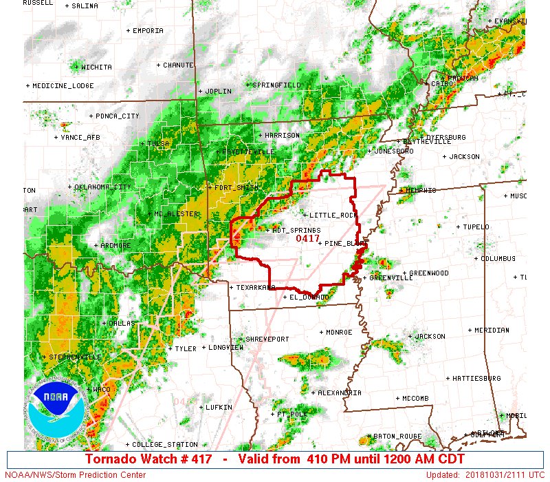
SPC has highlighted a large portion of Louisiana for the risk of tornadoes. These may occur after dark.

Day 1 Convective Outlook
NWS Storm Prediction Center Norman OK
1129 AM CDT Wed Oct 31 2018
Valid 311630Z - 011200Z
...THERE IS AN ENHANCED RISK OF SEVERE THUNDERSTORMS THROUGH TONIGHT
FROM SOUTHEASTERN TX TO SOUTHWESTERN MS...
...SUMMARY...
The greatest risk for severe thunderstorms, capable of producing
damaging winds, hail, and tornadoes, exists from southeast Texas to
the lower Mississippi Valley today through tonight.
...TX today to LA/MS overnight...
A midlevel shortwave trough now near El Paso will continue eastward
across TX through tonight. Weak cyclogenesis is expected by this
evening and continuing through tonight, along a pre-existing front
from central TX to the Mid South. A moist low-level air mass is
already present south of the front, with low 70s boundary-layer
dewpoints spreading across the northwest Gulf coast. Gradual mass
response to the cyclogenesis will result in strengthening low-level
flow/shear, especially tonight across LA/MS.
Ongoing convection in TX has largely remained elevated atop the
frontal surface, but may gradually transition to surface-based
storms along the front later this afternoon. Isolated strong-severe
storms will also be possible this afternoon/evening into southwest
TX, along the west edge of the richer low-level moisture and in the
zone of stronger low-midlevel ascent preceding the shortwave trough.
Farther east, the ongoing warm sector convection across the upper TX
coast should persist through the afternoon and spread slowly
eastward/northeastward. Additional warm sector storm development is
also expected tonight along the moist axis into southern LA.
Wind profiles are only marginally favorable for organized/supercell
storms at present across TX, with slow strengthening of vertical
shear expected later this afternoon through tonight farther east
toward the lower MS Valley. A few supercells could evolve from the
ongoing upper TX coast convection, as well as embedded
supercells/bowing segments along the front from central into east
TX. This frontal convection will likely evolve into a line that
will move eastward overnight, with an accompanying threat for
damaging winds and a couple of tornadoes with embedded circulations.
The more substantial supercell/tornado threat is expected overnight
into parts of LA (and possibly MS) within the moist sector, and
where low-level shear becomes the strongest. A strong tornado or
two will be possible, especially with any pre-frontal supercell
clusters, where effective SRH increases to greater than 400 m2/s2 in
a moist environment with sufficient surface-based buoyancy.
SPC has highlighted a large portion of Louisiana for the risk of tornadoes. These may occur after dark.
Day 1 Convective Outlook
NWS Storm Prediction Center Norman OK
1129 AM CDT Wed Oct 31 2018
Valid 311630Z - 011200Z
...THERE IS AN ENHANCED RISK OF SEVERE THUNDERSTORMS THROUGH TONIGHT
FROM SOUTHEASTERN TX TO SOUTHWESTERN MS...
...SUMMARY...
The greatest risk for severe thunderstorms, capable of producing
damaging winds, hail, and tornadoes, exists from southeast Texas to
the lower Mississippi Valley today through tonight.
...TX today to LA/MS overnight...
A midlevel shortwave trough now near El Paso will continue eastward
across TX through tonight. Weak cyclogenesis is expected by this
evening and continuing through tonight, along a pre-existing front
from central TX to the Mid South. A moist low-level air mass is
already present south of the front, with low 70s boundary-layer
dewpoints spreading across the northwest Gulf coast. Gradual mass
response to the cyclogenesis will result in strengthening low-level
flow/shear, especially tonight across LA/MS.
Ongoing convection in TX has largely remained elevated atop the
frontal surface, but may gradually transition to surface-based
storms along the front later this afternoon. Isolated strong-severe
storms will also be possible this afternoon/evening into southwest
TX, along the west edge of the richer low-level moisture and in the
zone of stronger low-midlevel ascent preceding the shortwave trough.
Farther east, the ongoing warm sector convection across the upper TX
coast should persist through the afternoon and spread slowly
eastward/northeastward. Additional warm sector storm development is
also expected tonight along the moist axis into southern LA.
Wind profiles are only marginally favorable for organized/supercell
storms at present across TX, with slow strengthening of vertical
shear expected later this afternoon through tonight farther east
toward the lower MS Valley. A few supercells could evolve from the
ongoing upper TX coast convection, as well as embedded
supercells/bowing segments along the front from central into east
TX. This frontal convection will likely evolve into a line that
will move eastward overnight, with an accompanying threat for
damaging winds and a couple of tornadoes with embedded circulations.
The more substantial supercell/tornado threat is expected overnight
into parts of LA (and possibly MS) within the moist sector, and
where low-level shear becomes the strongest. A strong tornado or
two will be possible, especially with any pre-frontal supercell
clusters, where effective SRH increases to greater than 400 m2/s2 in
a moist environment with sufficient surface-based buoyancy.
This post was edited on 10/31/18 at 11:16 pm
 26
26


Posted on 10/31/18 at 12:28 pm to rds dc

Posted on 10/31/18 at 12:28 pm to rds dc
Looks like a 3rd grade coloring book.
Posted on 10/31/18 at 12:28 pm to rds dc
is this like rain %? 10% of circle is a tornado?
Posted on 10/31/18 at 12:29 pm to rds dc
Maybe the tornadoes will clear up some of the traffic from the Sunshine Bridge.

Posted on 10/31/18 at 12:29 pm to rds dc
Meh they always predict bad weather and nothing happens
Posted on 10/31/18 at 12:33 pm to Chad504boy
quote:
is this like rain %? 10% of circle is a tornado?
Similiar. It's a 10% chance of a tornado passing within 25 miles of your location. The hatched circle is where EF2+ are possible.

Posted on 10/31/18 at 12:39 pm to Duke
It looks like whatever we get will roll through BR just in time for the am drive.... 
I'm an optimist. I'm going with a 90% chance one won't show up.
I'm an optimist. I'm going with a 90% chance one won't show up.
Posted on 10/31/18 at 12:39 pm to rds dc
Rds can correct me if I'm wrong, but I believe Louisiana only gets a hatched area about 4 or 5 days a year. This is a much better than normal chance for severe weather.
Posted on 10/31/18 at 12:46 pm to rds dc
hehehehehehehe
moist axis
moist axis
Posted on 10/31/18 at 12:46 pm to oleheat
quote:
It looks like whatever we get will roll through BR just in time for the am drive
The line is expected to be through by rush hour but not by much. The Northshore probably has the worst of the commute situation.
That squall line looks pretty stout on short range models, with some bowing segments that would have strong winds with it and dropping a quick couple of inches of rain.
The bigger concern is overnight though as cells that get going in front of the main line. Typical for severe events, it's those cells that bring the higher end tornado potential and hail threat. Any of those that get up have plenty of help to get rotating
Posted on 10/31/18 at 12:47 pm to Duke
quote:
It's a 10% chance of a tornado passing within 25 miles of your location
that's fairly rich.
Posted on 10/31/18 at 12:52 pm to Chad504boy
in all seriousness though...
gonna be a loooonnnnnnnngggggg night here in CenLA
gonna be a loooonnnnnnnngggggg night here in CenLA
Posted on 10/31/18 at 12:53 pm to rt3
also... Reed Timmer's flying into Houston right now to chase these storms tonight
so you know it's expected to be bad
so you know it's expected to be bad

Posted on 10/31/18 at 12:54 pm to rds dc
What time is this supposed to start?
Posted on 10/31/18 at 1:18 pm to rt3
quote:
Reed Timmer's flying into Houston right now to chase these storms tonight
Maybe but the chasers are pretty hard up after the bust of the spring season, well those who didn't ride out Michael at least.
Posted on 10/31/18 at 1:29 pm to rds dc
Im supposed to fly out of MSY to Dallas tomorrow am...what are the chances that flight gets delayed?
Posted on 10/31/18 at 1:32 pm to tgrbaitn08
1/350
Posted on 10/31/18 at 1:32 pm to Duke
quote:
The line is expected to be through by rush hour but not by much. The Northshore probably has the worst of the commute situation. That squall line looks pretty stout on short range models, with some bowing segments that would have strong winds with it and dropping a quick couple of inches of rain. The bigger concern is overnight though as cells that get going in front of the main line. Typical for severe events, it's those cells that bring the higher end tornado potential and hail threat. Any of those that get up have plenty of help to get rotating
Here's to hoping everyone stays safe, man. I hate this "perfect scenario" crap.....Just let it pass as quickly as possible- and goes easy on us all.
Posted on 10/31/18 at 1:32 pm to rds dc

This post was edited on 10/31/18 at 1:33 pm

 Page 1 of 26

Popular
Back to top