- My Forums
- Tiger Rant
- LSU Recruiting
- SEC Rant
- Saints Talk
- Pelicans Talk
- More Sports Board
- Coaching Changes
- Fantasy Sports
- Golf Board
- Soccer Board
- O-T Lounge
- Tech Board
- Home/Garden Board
- Outdoor Board
- Health/Fitness Board
- Movie/TV Board
- Book Board
- Music Board
- Political Talk
- Money Talk
- Fark Board
- Gaming Board
- Travel Board
- Food/Drink Board
- Ticket Exchange
- TD Help Board
Customize My Forums- View All Forums
- Show Left Links
- Topic Sort Options
- Trending Topics
- Recent Topics
- Active Topics
Started By
Message
 1
1


Posted on 4/2/17 at 12:04 am to rt3
Buckle up, lads.
Posted on 4/2/17 at 12:06 am to Scoop
quote:
Buckle up, lads.
It will be interesting to see what SPC does tonight, the last High Risk for the I10 corridor was like 2002 or something.
Posted on 4/2/17 at 12:14 am to Tiger Nation 84
quote:
Tired of having to fear these nasty arse storms. shite man we can't catch a damn break
No offense but why don't you just move? My great uncle used to live in Alaska and there was a pack of polar bears that were digging in his trash and eventually killed his dog. I urged him to move but he stayed in Ak and was killed about 5 years after that. From a heart attack not polar bears but the point stands. No sense in living in a place where natural disasters are common
Posted on 4/2/17 at 12:20 am to GEAUXmedic
Crap. I have to drive on the Causeway tomorrow morning and afternoon.
Posted on 4/2/17 at 12:21 am to rds dc
Short term model trends keep going towards a quick lineout with a few supercells out in front of the line early in the day, it seemed like that was the trend in every potential event in March and there was a lot of busts. These deep closed lows moving out of the four corners tend to bring alot of rain with some severe because there is no cap overhead to keep storms from forming overnight instead of the closed lows forming over the southern plains breaking the cap after building instability all day. Unless something changes, we'll probably see more of what we've been seeing this past month. Locally flooding rains and a few tornadoes to go with it early in the evening.

Posted on 4/2/17 at 12:23 am to Grim
quote:
No offense but why don't you just move? My great uncle used to live in Alaska and there was a pack of polar bears that were digging in his trash and eventually killed his dog. I urged him to move but he stayed in Ak and was killed about 5 years after that. From a heart attack not polar bears but the point stands. No sense in living in a place where natural disasters are common
This post was a masterpiece.
Posted on 4/2/17 at 12:25 am to Woopigsooie20
Is it the big one? Stay safe out there Tiger fans.
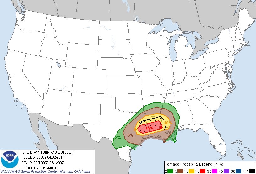
Posted on 4/2/17 at 1:11 am to LSUTigersVCURams
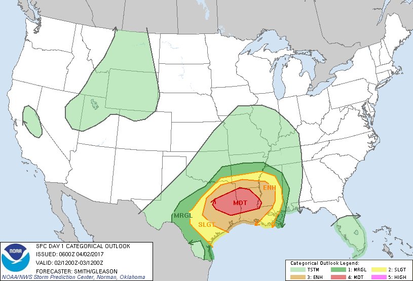
...SUMMARY...
Numerous severe thunderstorms are forecast from parts of Texas
eastward into the lower Mississippi Valley today and into tonight.
A concentrated area of significant wind damage is likely near and
north of the I-20 corridor in east Texas and Louisiana. The risk
for tornadoes, a few of which may be strong/damaging, will probably
maximize near and south of I-20 in Texas and Louisiana, along with
the threat for hail.
...Synopsis...
A closed mid-level low will evolve into an open wave and move from
northern Mexico/Far West TX eastward to the ArkLaTex by early Monday
morning. A broad area of surface low pressure over the Rio Grande
Valley will consolidate and develop northeast across central TX
during the day and be near the OK/AR border at the end of the
period. A maritime warm front will advance northward across the
northwest Gulf Coast region during the day as a cold front
accelerates eastward across central TX during the afternoon and into
LA during the overnight.
...Central TX eastward into the lower MS Valley...
A multi-hazard, likely multi-scenario forecast with intrinsic
complexity/uncertainty is seemingly evident for today into tonight.
Late Saturday evening surface analysis and radar imagery show rich
low-level moisture over the TX coast with a developing thunderstorm
cluster in the middle Rio Grande Valley. Strong to severe
thunderstorms will likely be ongoing over central TX. Severe
gusts/wind damage appears to be the predominate threat with the
early-day MCS. As the surface low deepens, a concurrent strong
low-level mass response will occur and the development of a 50-kt
LLJ by mid morning is expected. Strong low-level moist advection on
the nose of the LLJ will be favorable for a continuation of early
morning storms as the LLJ's terminus shifts eastward from
east-central TX into the ArkLaTex by mid-late afternoon. A
concentrated zone of higher probability wind potential may be
realized with a potential bowing system as increasing buoyancy
(1000-3000 J/kg MUCAPE) and strong shear lead to an intense bowing
MCS moving from TX into the ArkLaTex.
Coincident with the diurnal heating cycle, free warm sector
thunderstorm initiation is likely from east TX into LA on the
northern rim of the elevated mixed layer's stronger capping
inversion (north of Interstate 10). Persistent south-to-north
oriented confluence zones in the warm sector will serve as the
genesis areas with gradual thunderstorm/supercell development as
stronger updrafts penetrate the LFC---beginning as early as the late
morning and through the afternoon. A moderate to very unstable
boundary layer (MLCAPE ranging from 2000-3000 J/kg) is forecast from
eastern parts of TX into LA. Forecast soundings show large
hodographs (200-400 m2/s2 0-1 km SRH) with strong effective shear of
at least 50-kt. It seems plausible several supercells may evolve
from this activity and pose a threat for tornadoes and large to very
large hail. A couple of strong/damaging tornadoes are possible.
The latest model guidance suggests thunderstorm coverage will be
less generally south of Interstate 10. Nonetheless, models show
isolated to widely scattered storms developing perhaps in
conjunction with stronger deep forcing for ascent.
During the evening and overnight over the lower MS Valley, storms
will likely spread into the region from the west. Increasing
moisture/buoyancy as the maritime front advances northward will
favor an organized severe storm risk continuing into the region.
Thunderstorms within the strong flow fields will conditionally
support the possibility for wind damage and tornadoes after dark.
Posted on 4/2/17 at 1:19 am to GEAUXmedic
PUBLIC SEVERE WEATHER OUTLOOK
NWS STORM PREDICTION CENTER NORMAN OK
0114 AM CDT SUN APR 02 2017
...Severe thunderstorms expected over parts of the lower Mississippi
Valley and central/east Texas later today and tonight...
* LOCATIONS...
Central and East Texas
Louisiana
Southern Arkansas
Central and Southern Mississippi
* HAZARDS...
Widespread damaging winds, some hurricane force
Several tornadoes, a few intense
Scattered large hail, some baseball size
* SUMMARY...
Numerous severe thunderstorms are forecast from parts of Texas
eastward into the lower Mississippi Valley later today and
continuing into tonight. A concentrated area of significant wind
damage is likely near and north of the I-20 corridor in east
Texas and Louisiana. The risk for tornadoes, a few of which may
be strong/damaging, will probably maximize near and south of
I-20 in Texas and Louisiana, along with the threat for very
large hail.
Preparedness actions...
Review your severe weather safety procedures for the possibility
of dangerous weather today. Stay tuned to NOAA Weather Radio,
weather.gov, or other media for watches and warnings. A watch
means that conditions are favorable for severe thunderstorms
over the next several hours. If a severe thunderstorm warning is
issued for your area, move to a place of safety, ideally in an
interior room on the lowest floor of a sturdy building.
&&
..Gleason.. 04/02/2017
Posted on 4/2/17 at 1:24 am to GEAUXmedic
Latest NAM:


Posted on 4/2/17 at 1:26 am to GEAUXmedic
quote:holy frick
MLCAPE ranging from 2000-3000 J/kg

Posted on 4/2/17 at 1:27 am to Grim
quote:
No offense but why don't you just move?
I wonder how many people on here bitched about Katrina when they willingly live in a state on the coast of the mainland?

Posted on 4/2/17 at 1:31 am to Grim
quote:
No sense in living in a place where natural disasters are common
If you live east of the Rockies you're going to be in the path of tornados.
If you live on the west coast you have forest fires, earthquakes, and landslides.
If you live in America, chances are you're in the path of a possible natural disaster.
And fwiw the US sees some of the most violent storms you will find on Earth.
Posted on 4/2/17 at 1:31 am to McCaigBro69
Posted on 4/2/17 at 1:34 am to SabiDojo
quote:
If you live in America, chances are you're in the path of a possible natural disaster
lol exactly. You have a chance to get rocked by the natural disaster pretty much anywhere here.
Posted on 4/2/17 at 1:35 am to McCaigBro69
Latest QPF from an hour ago.

Posted on 4/2/17 at 1:36 am to GEAUXmedic
How is Jackson, MS looking?
Posted on 4/2/17 at 1:37 am to SabiDojo
quote:
How is Jackson, MS looking?


This post was edited on 4/2/17 at 1:38 am
Posted on 4/2/17 at 1:38 am to GEAUXmedic
Whew! I hope it stays that way. I appreciate y'all making these threads.

 Page 6 of 52

Popular
Back to top