- My Forums
- Tiger Rant
- LSU Recruiting
- SEC Rant
- Saints Talk
- Pelicans Talk
- More Sports Board
- Fantasy Sports
- Golf Board
- Soccer Board
- O-T Lounge
- Tech Board
- Home/Garden Board
- Outdoor Board
- Health/Fitness Board
- Movie/TV Board
- Book Board
- Music Board
- Political Talk
- Money Talk
- Fark Board
- Gaming Board
- Travel Board
- Food/Drink Board
- Ticket Exchange
- TD Help Board
Customize My Forums- View All Forums
- Show Left Links
- Topic Sort Options
- Trending Topics
- Recent Topics
- Active Topics
Started By
Message

 1
1

Posted on 4/2/17 at 3:35 pm to slackster
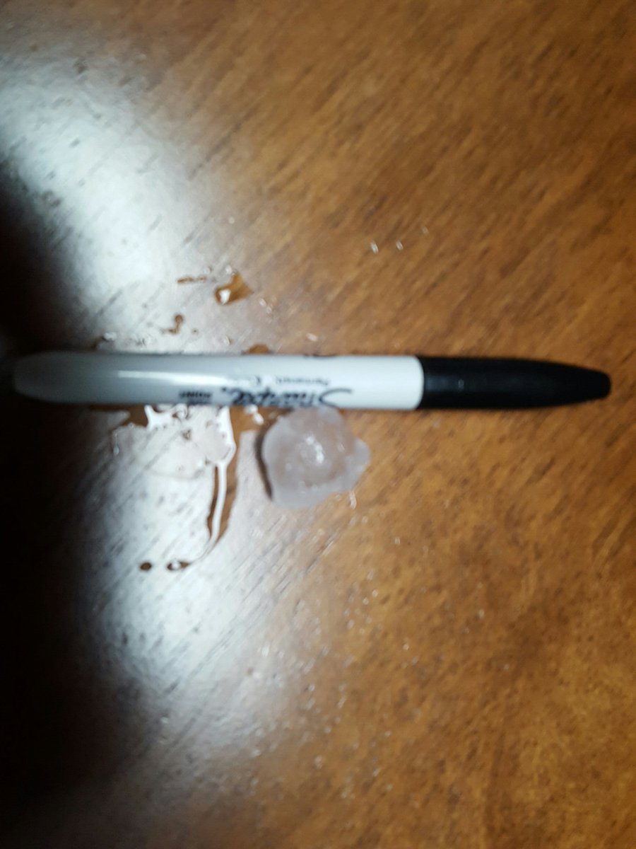
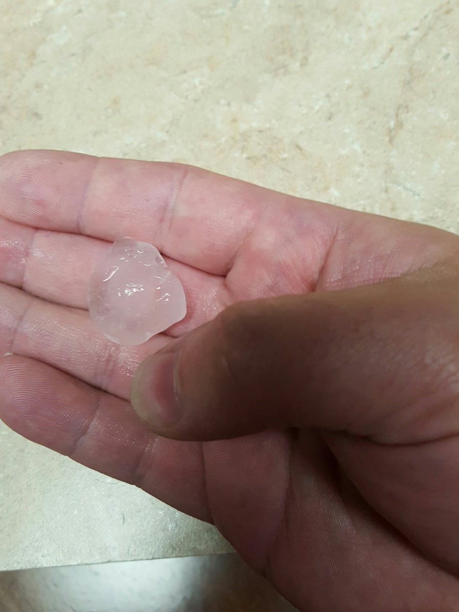
Pics of hail I just took... good little 30 seconds of hail at my place in Pineville
Posted on 4/2/17 at 3:36 pm to LSURussian
quote:
Nah, he just wants to announce that because of today's weather the upcoming legislature needs to increase taxes....
If this actually happened I wouldn't be surprised, but looking at this thread, I hope things don't get as bad as it has the potential to get.
Posted on 4/2/17 at 3:37 pm to slackster
That's has to be an EF-4 right?
Posted on 4/2/17 at 3:39 pm to GeorgeTheGreek
quote:
That's has to be an EF-4 right?
The one through Alexandria? Who knows. It was strongest on radar about 10-15 miles to the southwest and again 10-15 miles to the northeast of Alexandria. I'm not sure if Alexandria will be the best gauge of its peak strength.
ETA: A few miles west of Woodworth was when it looked most impressive ***This is an old image***

This post was edited on 4/2/17 at 3:43 pm

Posted on 4/2/17 at 3:39 pm to slackster
That's wicked.
Posted on 4/2/17 at 3:40 pm to OweO
[quote]If this actually happened I wouldn't be surprised, but looking at this thread, I hope things don't get as bad as it has the potential to get[/quote
PDS days are rare but they are very dangerous when issued.
PDS days are rare but they are very dangerous when issued.

Posted on 4/2/17 at 3:41 pm to LSURussian
quote:
he just wants to announce that because of today's weather the upcoming legislature needs to increase taxes....
Democrat gonna Democrat

Posted on 4/2/17 at 3:43 pm to GeorgeTheGreek

Posted on 4/2/17 at 3:44 pm to Ponchy Tiger
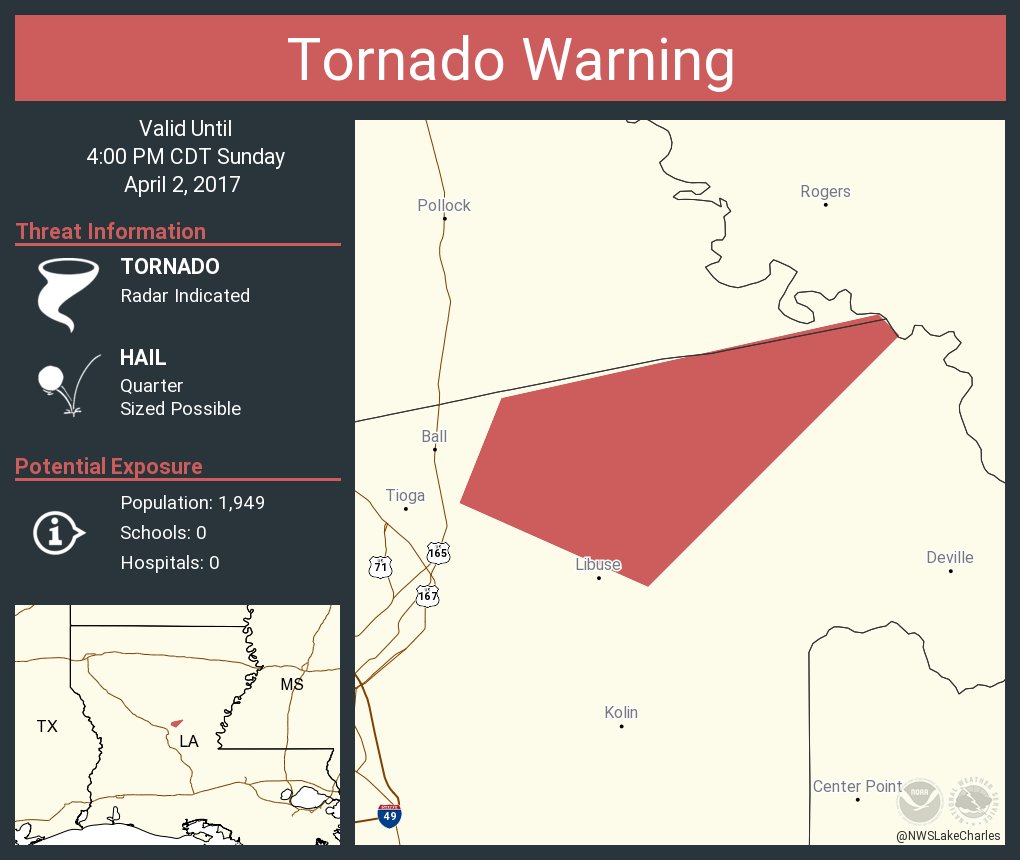
Tornado warning on the storm east of Pollock and Ball.
Posted on 4/2/17 at 3:44 pm to LaBR4
think the cell I just got the hail from is now tornado warned
Posted on 4/2/17 at 3:45 pm to Ponchy Tiger
New tornado warning due east of Ball, LA.
Figured this one was coming soon. The long-track cell that went through Alexandria is no longer warned in the Olla area. It was consistently warned for the past two hours, nearly 70 miles.
Figured this one was coming soon. The long-track cell that went through Alexandria is no longer warned in the Olla area. It was consistently warned for the past two hours, nearly 70 miles.

Posted on 4/2/17 at 3:46 pm to jorconalx
I just drove a loop in my area. Something went down between Heyman and MacArthur. Lots of trees down. Emergency vehicles errywhere. Saw some pines with the matchstick type snap. Every soft billboard is destroyed. Split bradford pear all over town.
Posted on 4/2/17 at 3:47 pm to rds dc
i starting to think this high risk area is a bust, a lot of convection forming ahead of the main line that isn't tornadic or even severe drawing energy away preventing multiple discrete supercells
Posted on 4/2/17 at 3:48 pm to rt3
I'd be surprised if we don't see a tornado warning on this cell south of Winnfield before it is said and done:

Posted on 4/2/17 at 3:49 pm to DVinBR

Warning continued on the cell near Ball.
Posted on 4/2/17 at 3:52 pm to DVinBR
quote:
i starting to think this high risk area is a bust,
Not much of a bust when practically the entire high risk area is under a severe thunderstorm warning at a minimum. The "high" risk doesn't apply to tornadoes only.

This post was edited on 4/2/17 at 3:53 pm
Posted on 4/2/17 at 3:54 pm to slackster
Looks like Alexandria might get another storm.
Posted on 4/2/17 at 3:55 pm to DVinBR
right now the main line of storms is in the middle of the high risk area, these big lines are just a wind and hail risk usually
Posted on 4/2/17 at 3:56 pm to slackster
Current tornado SW of Jena:

Whoa.
FWIW, this was the tornado from an hour and ten minutes ago:

Practically in the exact same spot. Damn.
Whoa.
FWIW, this was the tornado from an hour and ten minutes ago:
Practically in the exact same spot. Damn.

 Page 32 of 52

Popular
Back to top