- My Forums
- Tiger Rant
- LSU Recruiting
- SEC Rant
- Saints Talk
- Pelicans Talk
- More Sports Board
- Fantasy Sports
- Golf Board
- Soccer Board
- O-T Lounge
- Tech Board
- Home/Garden Board
- Outdoor Board
- Health/Fitness Board
- Movie/TV Board
- Book Board
- Music Board
- Political Talk
- Money Talk
- Fark Board
- Gaming Board
- Travel Board
- Food/Drink Board
- Ticket Exchange
- TD Help Board
Customize My Forums- View All Forums
- Show Left Links
- Topic Sort Options
- Trending Topics
- Recent Topics
- Active Topics
Started By
Message
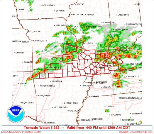
Tornado! Iowa City about to Get a Big One
Posted on 5/22/19 at 2:37 pm
Posted on 5/22/19 at 2:37 pm

URGENT - IMMEDIATE BROADCAST REQUESTED
Tornado Watch Number 211
NWS Storm Prediction Center Norman OK
230 PM CDT Wed May 22 2019
The NWS Storm Prediction Center has issued a
* Tornado Watch for portions of
Southwest and Central Oklahoma
Western North Texas
* Effective this Wednesday afternoon and evening from 230 PM
until 1000 PM CDT.
...THIS IS A PARTICULARLY DANGEROUS SITUATION...
URGENT - IMMEDIATE BROADCAST REQUESTED
Tornado Watch Number 212
NWS Storm Prediction Center Norman OK
330 PM CDT Wed May 22 2019
The NWS Storm Prediction Center has issued a
* Tornado Watch for portions of
Southeast Kansas
Central and Southwest Missouri
Northeast Oklahoma
* Effective this Wednesday afternoon and evening from 330 PM
until 1100 PM CDT.
...THIS IS A PARTICULARLY DANGEROUS SITUATION...
This post was edited on 5/24/19 at 7:08 pm
 13
13

Posted on 5/22/19 at 2:42 pm to rds dc
quote:
PARTICULARLY
as opposed to unparticularly?
Posted on 5/22/19 at 2:44 pm to Chad504boy
quote:
as opposed to unparticularly?
Take it up with SPC.
Posted on 5/22/19 at 2:47 pm to rds dc
Dang. Not even in the Moderate area too.
80% of EF2+...That's pretty hefty.
80% of EF2+...That's pretty hefty.
This post was edited on 5/22/19 at 2:48 pm
Posted on 5/22/19 at 2:51 pm to rds dc
PDS came out of nowhere, it's not even in the mod risk area
Posted on 5/22/19 at 2:52 pm to DVinBR
The concern was would storms really fire in that part, looks like 1 has.
Posted on 5/22/19 at 2:52 pm to ElOsoBlanco7
quote:
Dang. Not even in the Moderate area too.
80% of EF2+...That's pretty hefty.
The Falls was barely in the Marginal earlier. From Marginal to PDS, wild day.

Posted on 5/22/19 at 2:54 pm to rds dc
I’m over this mess already.
Posted on 5/22/19 at 2:57 pm to rds dc
When I pull it up on weather.gov, nothing is said about the watch being a "particularly dangerous situation.
TORNADO WATCH OUTLINE UPDATE FOR WT 211
NWS STORM PREDICTION CENTER NORMAN OK
230 PM CDT WED MAY 22 2019
TORNADO WATCH 211 IS IN EFFECT UNTIL 1000 PM CDT FOR THE
FOLLOWING LOCATIONS
OKC015-017-019-027-029-031-033-049-051-063-067-069-073-075-081-
083-085-087-095-099-109-119-123-125-133-137-141-230300-
/O.NEW.KWNS.TO.A.0211.190522T1930Z-190523T0300Z/
OK
. OKLAHOMA COUNTIES INCLUDED ARE
CADDO CANADIAN CARTER
CLEVELAND COAL COMANCHE
COTTON GARVIN GRADY
HUGHES JEFFERSON JOHNSTON
KINGFISHER KIOWA LINCOLN
LOGAN LOVE MARSHALL
MCCLAIN MURRAY OKLAHOMA
PAYNE PONTOTOC POTTAWATOMIE
SEMINOLE STEPHENS TILLMAN
$$
Posted on 5/22/19 at 2:57 pm to rds dc
These are the days that stand out to me. The models that come out of nowhere and explode. I remember in 2011 Joplin was under a Slight risk the day before, then that insane tornado hit the next day under a hatched moderate risk.
The SigTor values have some nasty looking bullseyes on the HRRR, so we might see a few big ones today.
The SigTor values have some nasty looking bullseyes on the HRRR, so we might see a few big ones today.

Posted on 5/22/19 at 3:00 pm to rds dc
I’m surprised they’re going PDS given Monday not panning out quite as was forecast.
Posted on 5/22/19 at 3:01 pm to Roll Tide Ravens

That looks pretty nasty too.

Posted on 5/22/19 at 3:08 pm to ElOsoBlanco7
Twitter WX folks seem to be concerned about that storm moving toward Moore/Norman entering a really favorable environment in the next couple of hours - is that right?

Posted on 5/22/19 at 3:11 pm to Pettifogger
quote:
moving toward Moore/
No, just no. They've had a lifetime of tornadoes
Posted on 5/22/19 at 3:12 pm to Pettifogger
quote:
Moore/Norman entering a really favorable environment
Storms are just starting to pop, but there's enough instability to give it some juice.
Posted on 5/22/19 at 3:23 pm to ElOsoBlanco7
Posted on 5/22/19 at 3:33 pm to AHM21
wall cloud for sure on that feed.
Posted on 5/22/19 at 3:36 pm to lsuman25
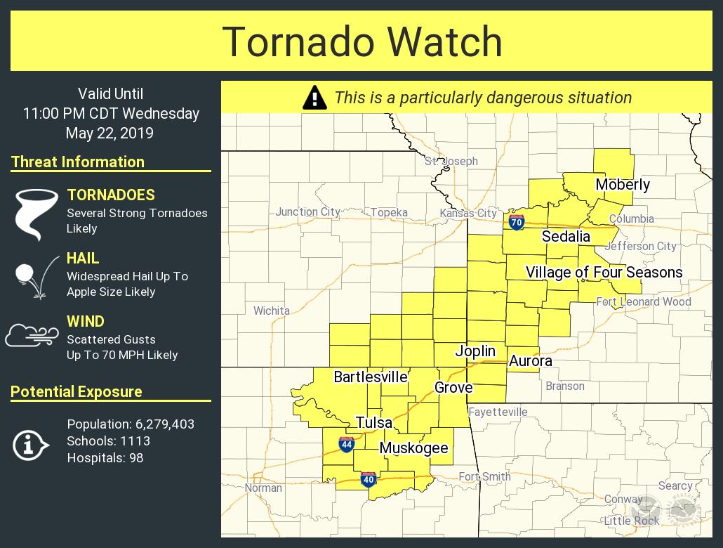
New PDS Tornado Watch for parts of Oklahoma, Kansas, and Missouri. 80/80 probabilities on it.
quote:
URGENT - IMMEDIATE BROADCAST REQUESTED
Tornado Watch Number 212
NWS Storm Prediction Center Norman OK
330 PM CDT Wed May 22 2019
The NWS Storm Prediction Center has issued a
* Tornado Watch for portions of
Southeast Kansas
Central and Southwest Missouri
Northeast Oklahoma
* Effective this Wednesday afternoon and evening from 330 PM
until 1100 PM CDT.
...THIS IS A PARTICULARLY DANGEROUS SITUATION...
* Primary threats include...
Several tornadoes and a few intense tornadoes likely
Widespread large hail and scattered very large hail events to 3
inches in diameter likely
Scattered damaging wind gusts to 70 mph likely
SUMMARY...Thunderstorms are expected to develop across the watch
area this afternoon and spread northeastward through the evening.
Supercells capable of very large hail, damaging winds, and strong
tornadoes are possible.
The tornado watch area is approximately along and 80 statute miles
north and south of a line from 60 miles west southwest of Tulsa OK
to 60 miles east northeast of Knob Noster MO. For a complete
depiction of the watch see the associated watch outline update
(WOUS64 KWNS WOU2).
quote:
Tornadoes
Probability of 2 or more tornadoes - High (80%)
Probability of 1 or more strong (EF2-EF5) tornadoes - High (80%)
This post was edited on 5/22/19 at 3:40 pm
Posted on 5/22/19 at 3:36 pm to lsuman25
This stream could be getting very interesting

Posted on 5/22/19 at 3:36 pm to lsuman25
Yea definitely an all or nothing day. That how it was here yesterday. Went more towards nothing thankfully.

 Page 1 of 13

Popular
Back to top